Maps of Arad

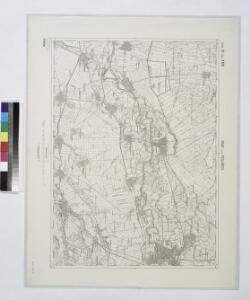
Arad und Perjamos.; Spezialkarte der osterreichisch-ungarischen Monarchie.
from Spezialkarte der osterreichisch-ungarischen Monarchie. Austro-Hungarian Monarchy. Militärgeographisches Institut.,
Arad
1 : 75000 Arad (Rumänien)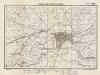
Lambert-Cholesky sheet 1663 (Pecica)
1 : 20000 Romanian military topographic map sheet under Lambert-Cholensky projection Direcția Topografică Militară geo-spatial.org Direcția Topografică Militară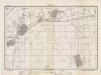
Lambert-Cholesky sheet 1662 (Secusigiul)
1 : 20000 Romanian military topographic map sheet under Lambert-Cholensky projection Direcția Topografică Militară geo-spatial.org Direcția Topografică Militară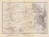
Lambert-Cholesky sheet 1763 (Arad)
1 : 20000 Romanian military topographic map sheet under Lambert-Cholensky projection Direcția Topografică Militară geo-spatial.org Direcția Topografică Militară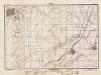
Lambert-Cholesky sheet 1762 (Şagul)
1 : 20000 Romanian military topographic map sheet under Lambert-Cholensky projection Direcția Topografică Militară geo-spatial.org Direcția Topografică Militară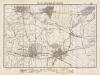
Lambert-Cholesky sheet 1562 (Periam)
1 : 20000 Romanian military topographic map sheet under Lambert-Cholensky projection Direcția Topografică Militară geo-spatial.org Direcția Topografică Militară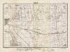
Lambert-Cholesky sheet 1563 (Nădlac Est)
1 : 20000 Romanian military topographic map sheet under Lambert-Cholensky projection Direcția Topografică Militară geo-spatial.org Direcția Topografică Militară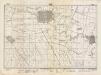
Lambert-Cholesky sheet 1664 (Turnul)
1 : 20000 Romanian military topographic map sheet under Lambert-Cholensky projection Direcția Topografică Militară geo-spatial.org Direcția Topografică Militară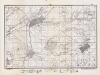
Lambert-Cholesky sheet 1761 (Vinga)
1 : 20000 Romanian military topographic map sheet under Lambert-Cholensky projection Direcția Topografică Militară geo-spatial.org Direcția Topografică Militară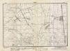
Lambert-Cholesky sheet 1764 (Variaşu)
1 : 20000 Romanian military topographic map sheet under Lambert-Cholensky projection Direcția Topografică Militară geo-spatial.org Direcția Topografică Militară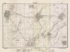
Lambert-Cholesky sheet 1661 (Mănăștur)
1 : 20000 Romanian military topographic map sheet under Lambert-Cholensky projection Direcția Topografică Militară geo-spatial.org Direcția Topografică Militară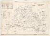
Arader Comitat
1 : 290000
Arader Comitat
1 : 288000 Arad (Rumunsko)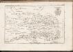
C. Aradiensis
Rumänien Komitat Arad (Rumänien)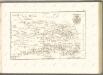
C. Csanád
Ungarn Csanád (Megye)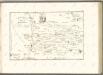

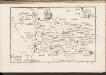
Tekintetes Temes vármegye térképe
Temešvár (Rumunsko) Györy, Lajos Beichel, J.
Höhenkarte
Banat Gelände
Die hydrographischen Verhältnisse der Heide
Banat Hydrologie
Die Lage der Heide im natürlichen Landschaftsraum
Banat Landschaftsgliederung
Das heutige Landschafts- und Siedlungsbild der Banater Schwäbischen Heide
Banat
Die Banater Schwäbische Heide zur Ansiedlungszeit nach den Originalkarten des Temeswarer Banats, aufgenommen 1769-1772 Kriegsarchiv Wien
Banat
Temesvar und Sandorhaza.
from Spezialkarte der osterreichisch-ungarischen Monarchie.
Die Nationalitätenverhältnisse der Banater Schwäbischen Heide nach der Volkszählung 1930/31
Banat ethnische Gruppe
Lippa.
from Spezialkarte der osterreichisch-ungarischen Monarchie.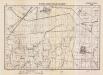
Lambert-Cholesky sheet 1564 (Nemet-Pereg)
1 : 20000 Romanian military topographic map sheet under Lambert-Cholensky projection Serviciul Geografic al Armatei geo-spatial.org Serviciul Geografic al Armatei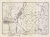
Lambert-Cholesky sheet 1561 (Pesac)
1 : 20000 Romanian military topographic map sheet under Lambert-Cholensky projection Direcția Topografică Militară geo-spatial.org Direcția Topografică Militară