Maps of Bohinj

Radmannsdorf.
from Spezialkarte der osterreichisch-ungarischen Monarchie.
Yugoslavia 1:100,000, Bled
Yugoslavia 1:100,000 , Series GSGS 4396. Great Britain. War Office. [London] : War Office
Radmannsdorf
1 : 75000 Radovljica, Radovljica (Region)
Julische Alpen
1 : 50000 Julské Alpy (Itálie a Slovinsko : pohoří) K. u. k. Militärgeographisches Institut
Julijske Alpe
1 : 75000 Julské Alpy (Itálie a Slovinsko) Knafelc, Alojz Slov. Plan. društvo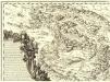
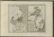
Ducatus Carnioliae Tabula Chorographica Iusu Sumptuque inclytorum Provinciae Statuum.
1 : 100000 Mollova mapová sbírka Florjančič de Grienfeld, Janez Dizma
St. Jakob
1 : 25000 Kartographisches Institut
Klagenfurt und Villach.
from Spezialkarte der osterreichisch-ungarischen Monarchie.
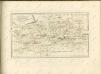
Bischoflack und Idria.
from Spezialkarte der osterreichisch-ungarischen Monarchie.
Italy 1:100,000 / Sardinia 1:100,000, Idria
Italy 1:100,000 / Sardinia 1:100,000 , Series GSGS 4164. Great Britain. War Office. General Staff. Geographical Section. [London] : War Office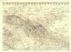
Ducatus Carnioliae Tabula Chorographica Iusu Sumptuque inclytorum Provinciae Statuum.
1 : 100000 Mollova mapová sbírka Florjančič de Grienfeld, Janez Dizma
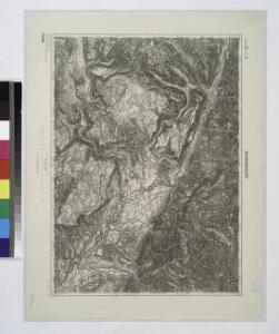
Zone 21, Kol. X, Bischoflack und Idria, uit: Geologische Karte der im Reichsrathe vertretenen Königreiche und Länder der Österreich-Ungarischen Monarchie : auf Grundlage der Specialkarte i.M. 1:75.000 des k.u.k. Militär-geographischen Institutes / neu bearb. und als Kartenwerk von 341 Blattnummern in zwanglosen Lfg. hrsg. durch die k.k. Geologische Reichsanstalt in Wien
1 : 75000 titelvariant: Geologische Spezialkarte der im Reichsrate vertretenen Königreiche und Länder der Österreichisch-Ungarischen Monarchie; Geologische Specialkarte der im Reichsrathe vertretenen Königreiche und Länder der Österreichisch-Ungarischen Monarchie; Annotatie: Titel bovenaan kaartblad: Geologische Spezialkarte der im Reichsrate vertretenen Königreiche und Länder der Österreichisch-Ungarischen Monarchie en Geologische Specialkarte der im Reichsrathe vertretenen Königreiche und Länder der Österreichisch-Ungarischen Monarchie; Annotatie geografische gegevens: Coördinaten gebaseerd op nulmeridiaan van Ferro (Hierro) Kaiserlich-Königliche Geologische Reichsanstalt, Wenen Wien : K.K. Geologische Reichsanstalt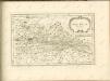

Dioecesan-Carte von Laibach
1 : 260000 Lublaň-oblast (Slovinsko) Mascon, Johann Wolf, Anton Alojzij Johann Mascon
Aus der Übersichtskarte von Mittel-Europa 1:750 000
1 : 750000 Evropa střední K. k. Österreichische Staatsbahnen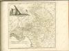

Generalkarte von Zentraleuropa

Der südliche Theil von Untersteyermark oder der Cillier Kreis
1 : 260000 Celje (Slovinsko) Kindermann, Joseph Karl Junker, Christoph Franz Xaver Miller
G. Freytags Karte der Isonzo-Front
1 : 350000 Gorizia (Itálie : provincie) Kartogr. Anstalt G. Freytag & Berndt
Karte vom Herzogthum Krain
1 : 290000 Kraňsko Loschan, Gottfried Stein, Carl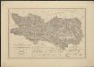
Die Land- und Wasser Communicationen des Herzogthumes Kärnten
1 : 288000 hrsg. von der K.K Direction der administrativen Statistik Wien : K.K Direction der administrativen Statistik
Carinthiae Dvcatvs, Et Goritiae Palatinatvs
1 : 460000 Mollova mapová sbírka Lazius, Wolfgang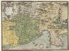
Fori Ivlii Accvrata Descriptio
1 : 400000 Mollova mapová sbírka Sambucus, Joannes Ortelius, Abraham
Fori Ivlii Vvlgo Frivli Typvs
1 : 800000 Mollova mapová sbírka Ortelius, Abraham Ortelius, Abraham
Ducatus Carinthiae tabula
1 : 740000 Korutansko (Rakousko) Granelli, Carlo Engelbrecht, Christian Pfeffel et Engelbrecht
General-Karte von Kärnten
1 : 300000 Klagenfurt (Rakousko) R. Lechner
General-Karte von Kärnten
1 : 300000 Klagenfurt (Rakousko) R. Lechner
Reichsratwahlkarte