Maps of Harghita

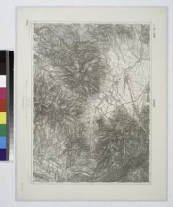
Gyergyo.
from Spezialkarte der osterreichisch-ungarischen Monarchie.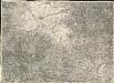
Gyergyó
1 : 75000 Gheorgheni, Judeţ Harghita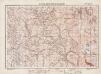
Lambert-Cholesky sheet 4069 (M-tele Vf. Calului)
1 : 20000 Romanian military topographic map sheet under Lambert-Cholensky projection Institutul Geografic Militar geo-spatial.org Institutul Geografic Militar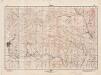
Lambert-Cholesky sheet 4068 (Voslobeni)
1 : 20000 Romanian military topographic map sheet under Lambert-Cholensky projection Direcția Topografică Militară geo-spatial.org Direcția Topografică Militară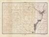
Lambert-Cholesky sheet 4067 (Sândominic)
1 : 20000 Romanian military topographic map sheet under Lambert-Cholensky projection Direcția Topografică Militară geo-spatial.org Direcția Topografică Militară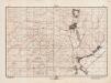
Lambert-Cholesky sheet 4066 (Mădăraş)
1 : 20000 Romanian military topographic map sheet under Lambert-Cholensky projection Direcția Topografică Militară geo-spatial.org Direcția Topografică Militară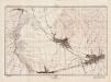
Lambert-Cholesky sheet 3969 (Ghiorghieni)
1 : 20000 Romanian military topographic map sheet under Lambert-Cholensky projection Direcția Topografică Militară geo-spatial.org Direcția Topografică Militară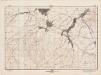
Lambert-Cholesky sheet 3968 (Ciumani)
1 : 20000 Romanian military topographic map sheet under Lambert-Cholensky projection Direcția Topografică Militară geo-spatial.org Direcția Topografică Militară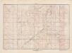
Lambert-Cholesky sheet 3967 (Liban)
1 : 20000 Romanian military topographic map sheet under Lambert-Cholensky projection Direcția Topografică Militară geo-spatial.org Direcția Topografică Militară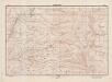
Lambert-Cholesky sheet 3966 (Muntele Harghita)
1 : 20000 Romanian military topographic map sheet under Lambert-Cholensky projection Direcția Topografică Militară geo-spatial.org Direcția Topografică Militară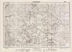
Lambert-Cholesky sheet 3869 (Poiana Draguşa)
1 : 20000 Romanian military topographic map sheet under Lambert-Cholensky projection Direcția Topografică Militară geo-spatial.org Direcția Topografică Militară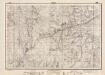
Lambert-Cholesky sheet 3868 (Tătarca)
1 : 20000 Romanian military topographic map sheet under Lambert-Cholensky projection Direcția Topografică Militară geo-spatial.org Direcția Topografică Militară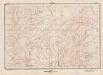
Lambert-Cholesky sheet 3867 (Lăzurele)
1 : 20000 Romanian military topographic map sheet under Lambert-Cholensky projection Direcția Topografică Militară geo-spatial.org Direcția Topografică Militară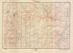
Lambert-Cholesky sheet 3866 (Piatra Şoimului)
1 : 20000 Romanian military topographic map sheet under Lambert-Cholensky projection Direcția Topografică Militară geo-spatial.org Direcția Topografică Militară
Olahfalu und Csik-Szereda.
from Spezialkarte der osterreichisch-ungarischen Monarchie.
Oláhfalu
1 : 75000 Judeţ Harghita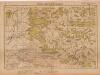
Lambert-Cholesky sheet 4166 (Săpiz)
1 : 20000 Romanian military topographic map sheet under Lambert-Cholensky projection Serviciul Geografic al Armatei geo-spatial.org Serviciul Geografic al Armatei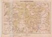
Lambert-Cholesky sheet 4167 (Ghiurca)
1 : 20000 Romanian military topographic map sheet under Lambert-Cholensky projection Serviciul Geografic al Armatei geo-spatial.org Serviciul Geografic al Armatei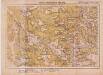
Lambert-Cholesky sheet 4168 (Bukkhavaspataka)
1 : 20000 Romanian military topographic map sheet under Lambert-Cholensky projection Serviciul Geografic al Armatei geo-spatial.org Serviciul Geografic al Armatei
Lambert-Cholesky sheet 4169 (Ciungi)
1 : 20000 Romanian military topographic map sheet under Lambert-Cholensky projection Serviciul Geografic al Armatei geo-spatial.org Serviciul Geografic al Armatei
Ost-Karpathen
1 : 600000 Karpaten (Südost)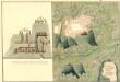
Plan des Bergwergs Weres Patack
Mollova mapová sbírka Geyer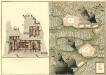
Plan der Bergwerg Indol und Gabor
Mollova mapová sbírka Geyer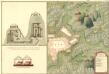
Plan des Bergwergs Igen.
Mollova mapová sbírka Geyer
Szovata.
from Spezialkarte der osterreichisch-ungarischen Monarchie.
Gyimes-Pasz.
from Spezialkarte der osterreichisch-ungarischen Monarchie.
Oláh-Toplica
1 : 75000 Topliţa, Judeţ Harghita
Olah-Toplicza.; Spezialkarte der osterreichisch-ungarischen Monarchie.
from Spezialkarte der osterreichisch-ungarischen Monarchie. Austro-Hungarian Monarchy. Militärgeographisches Institut.,
Gyimes-Pasz
1 : 75000 Miercurea-Ciuc, Judeţ Harghita