Maps of Cortina d'Ampezzo

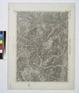
Toblach und Cortina D'ampezzo #10152 (Small).
from Spezialkarte der osterreichisch-ungarischen Monarchie.
Geologische Übersichtskarte des tirolisch-venetianischen Hochlandes zwischen Etsch und Piave
1 : 75000 Nordost-Blatt Mojsisovics, Edmund von Hölder
Toblach und Cortina D'ampezzo 10151 (Lrg.).; Spezialkarte der osterreichisch-ungarischen Monarchie.
from Spezialkarte der osterreichisch-ungarischen Monarchie. Austro-Hungarian Monarchy. Militärgeographisches Institut.,
Sillan
1 : 25000 Hauptvermessungsabteilung XIV
Kalkstein
1 : 25000 Hauptvermessungsabteilung XIV
Tyrolis sub Felici Regimine Mariae Theresiae Rom. Imper. Avg. Chorographice Delineata ...
1 : 104000 Mollova mapová sbírka Mansfeld, Johann Ernst Mansfeld, Johann Ernest
Tyrolis sub Felici Regimine Mariae Theresiae Rom. Imper. Avg. Chorographice Delineata ...
1 : 104000 Mollova mapová sbírka Mansfeld, Johann Ernst Mansfeld, Johann Ernest
Bruneck (Tirol).
from Spezialkarte der osterreichisch-ungarischen Monarchie.
Pieve Di Livinallongo und Longarone.
from Spezialkarte der osterreichisch-ungarischen Monarchie.
Sillian und St.Stefano Di Cadore.
from Spezialkarte der osterreichisch-ungarischen Monarchie.
Geologische Übersichtskarte des tirolisch-venetianischen Hochlandes zwischen Etsch und Piave
1 : 75000 Ostblatt Mojsisovics, Edmund von Hölder
Pieve Di Livinallongo und Longarone.; Spezialkarte der osterreichisch-ungarischen Monarchie.
from Spezialkarte der osterreichisch-ungarischen Monarchie. Austro-Hungarian Monarchy. Militärgeographisches Institut.,
Sillian und S. Stefano di Cadore
1 : 75000 Kartographisches, früher Militärgeographisches Institut
Auszervillgraten
1 : 25000 Hauptvermessungsabteilung XIV
Carte du Tyrol
1 : 150000 Ost-Blatt Anich, Peter par le Dépôt Général de la Guerre
Il Cadorino [Karte], in: Novus atlas absolutissimus, Bd. 5, S. 33.
1 Karte aus Atlas Janssonius Offizin
Il Cadorino [Karte], in: Theatrum orbis terrarum, sive, Atlas novus, Bd. 3, S. 125.
1 Karte aus Atlas Blaeu, Joan Blaeu, Willem Janszoon
Il Cadorino [Karte], in: Le théâtre du monde, ou, Nouvel atlas contenant les chartes et descriptions de tous les païs de la terre, Bd. 3, S. 147.
1 Karte aus Atlas Blaeu, Willem Janszoon und Blaeu, Joan Blaeu, Willem Janszoon
Il Cadorino [Karte], in: Novus Atlas, das ist, Weltbeschreibung, Bd. 3, S. 145.
1 Karte aus Atlas Blaeu, Joan Blaeu, Willem Janszoon
Drahtseilbahn Cortina-Belvedere
Cortina d'Ampezzo (Itálie) A. Dandrea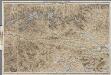
[Kaart], uit: Karte der Ost-Tiroler Alpen, Tauern und Dolomiten / von Ludwig Ravenstein
1 : 250000 Ravenstein, Ludwig Frankfurt am Main : Ravenstein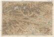
Karte der Ost-Tiroler Alpen, Tauern und Dolomiten
1 : 250000 Dolomity (Itálie) Ravenstein, Ludwig Ludwig Ravenstein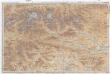
Karte der Ost-Tiroler Alpen, Tauern und Dolomiten
1 : 250000 Dolomity (Itálie) Ravenstein, Ludwig Ludwig. Ravenstein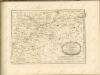

Tirolis
Mollova mapová sbírka Hoffmann, Johannes Hoffmann, Johann
Territorio Di Trento [Karte], in: Novus Atlas, das ist, Weltbeschreibung, Bd. 3, S. 154.
1 Karte aus Atlas Blaeu, Joan Blaeu, Willem Janszoon
TERRITORIO | DI | TRENTO.
Excudebat | Guiljelmus Blaeu.
Territorio Di Trento [Karte], in: Theatrum orbis terrarum, sive, Atlas novus, Bd. 3, S. 134.
1 Karte aus Atlas Blaeu, Joan Blaeu, Willem Janszoon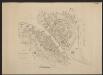
Territorium Tridentinum [Karte], in: Gerardi Mercatoris et I. Hondii Newer Atlas, oder, Grosses Weltbuch, Bd. 2, S. 228.
1 Karte aus Atlas Mercator, Gerhard und Hondius, Jodocus Jansson, Jan