Maps of Salten-Schlern - Salto-Sciliar

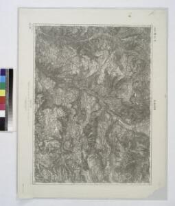
Klausen. #10149(Large)
from Spezialkarte der osterreichisch-ungarischen Monarchie.
G. Freytag's Übersichtskarte der Dolomiten
1 : 100000 Dolomity (Itálie) G. Freytag & Berndt
Klausen. 10150 (Small); Spezialkarte der osterreichisch-ungarischen Monarchie.
from Spezialkarte der osterreichisch-ungarischen Monarchie. Austro-Hungarian Monarchy. Militärgeographisches Institut.,
Geologische Übersichtskarte des tirolisch-venetianischen Hochlandes zwischen Etsch und Piave
1 : 75000 Nordwest-Blatt Mojsisovics, Edmund von Hölder
Tyrolis sub Felici Regimine Mariae Theresiae Rom. Imper. Avg. Chorographice Delineata ...
1 : 104000 Mollova mapová sbírka Mansfeld, Johann Ernst Mansfeld, Johann Ernest
Geologische Aufnahmskarte des Fassa-Grödner Überschiebungsgebietes in den Südtiroler Dolomiten / von Maria M. Ogilvie Gordon
1 : 25000 titelvariant: Geologische Karte der Fassa-Grodener Dolomiten; Annotatie: Titel op omslag: Geologische Karte der Fassa-Grodener Dolomiten [Wien : Freytag & Berndt]
Übersichtskarte von Bozen-Gries u. Umgebung
1 : 30000 Gries (Bolzano, Itálie) Oertel F. C. W. Vogel
Karte des Schlern und der Rosengartengruppe

Karte des Schlern und der Rosengartengruppe
1 : 25000 Simon, Simon Deutscher u. Oesterreichischer Alpen Verein
Botzen mit der Gegend auf 2 Stunden
1 : 160000 Mollova mapová sbírka Bodenehr, Gabriel Bodenehr, Gabriel
G. Freytags Touristen Wanderkarte der Dolomiten
1 : 100000 Dolomity (Itálie : pohoří) Freytag, Gustav G. Freytag & Berdt
Tyrolis sub Felici Regimine Mariae Theresiae Rom. Imper. Avg. Chorographice Delineata ...
1 : 104000 Mollova mapová sbírka Mansfeld, Johann Ernst Mansfeld, Johann Ernest
Tyrolis sub Felici Regimine Mariae Theresiae Rom. Imper. Avg. Chorographice Delineata ...
1 : 104000 Mollova mapová sbírka Mansfeld, Johann Ernst Mansfeld, Johann Ernest
Brenner-Bahn
1 : 96000 Bolzano (Itálie) Fr. Unterberger's Kunsthandlung
Sterzing und Franzensfeste (Tirol).
from Spezialkarte der osterreichisch-ungarischen Monarchie.
Bozen und Fleimsthal.
from Spezialkarte der osterreichisch-ungarischen Monarchie.
Karte von Bozen und Umgebung
1 : 100000 Heintz, C.
Geologische Übersichtskarte des tirolisch-venetianischen Hochlandes zwischen Etsch und Piave
1 : 75000 Westblatt Mojsisovics, Edmund von Hölder
Bozen und Fleimsthal.; Spezialkarte der osterreichisch-ungarischen Monarchie.
from Spezialkarte der osterreichisch-ungarischen Monarchie. Austro-Hungarian Monarchy. Militärgeographisches Institut.,
Drahtseilbahn Cortina-Belvedere
Cortina d'Ampezzo (Itálie) A. Dandrea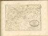

Tyrolis pars meridionalis
1 : 218000 Trident (Itálie : provincie) Spergs, Ioseph de Homannianis Hered.
Tirolis
Mollova mapová sbírka Hoffmann, Johannes Hoffmann, Johann
Territorio Di Trento [Karte], in: Novus Atlas, das ist, Weltbeschreibung, Bd. 3, S. 154.
1 Karte aus Atlas Blaeu, Joan Blaeu, Willem Janszoon

TERRITORIO | DI | TRENTO.
Excudebat | Guiljelmus Blaeu.
Territorio Di Trento [Karte], in: Theatrum orbis terrarum, sive, Atlas novus, Bd. 3, S. 134.
1 Karte aus Atlas Blaeu, Joan Blaeu, Willem Janszoon
Territorium Tridentinum [Karte], in: Gerardi Mercatoris et I. Hondii Newer Atlas, oder, Grosses Weltbuch, Bd. 2, S. 228.
1 Karte aus Atlas Mercator, Gerhard und Hondius, Jodocus Jansson, Jan
Territorium Tridentinum [Karte], in: Novus atlas absolutissimus, Bd. 2, S. 223.
1 Karte aus Atlas Janssonius Offizin