Maps of Bistrita-Nasaud

Marosborgo.; Spezialkarte der osterreichisch-ungarischen Monarchie.
from Spezialkarte der osterreichisch-ungarischen Monarchie. Austro-Hungarian Monarchy. Militärgeographisches Institut.,
Marosborgó
1 : 75000 Bistriţa-Năsăud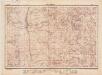
Lambert-Cholesky sheet 3774 (Virful Tamaului)
1 : 20000 Romanian military topographic map sheet under Lambert-Cholensky projection Direcția Topografică Militară geo-spatial.org Direcția Topografică Militară
Lambert-Cholesky sheet 3773 (Vârful Pietrosul)
1 : 20000 Romanian military topographic map sheet under Lambert-Cholensky projection Direcția Topografică Militară geo-spatial.org Direcția Topografică Militară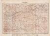
Lambert-Cholesky sheet 3674 (Mureşenii Bîrgăului)
1 : 20000 Romanian military topographic map sheet under Lambert-Cholensky projection Direcția Topografică Militară geo-spatial.org Direcția Topografică Militară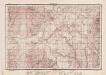
Lambert-Cholesky sheet 3673 (Piatra lui Orban)
1 : 20000 Romanian military topographic map sheet under Lambert-Cholensky projection Direcția Topografică Militară geo-spatial.org Direcția Topografică Militară
Lambert-Cholesky sheet 3672 (Poiana Culmilor)
1 : 20000 Romanian military topographic map sheet under Lambert-Cholensky projection Direcția Topografică Militară geo-spatial.org Direcția Topografică Militară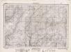
Lambert-Cholesky sheet 3772 (Bâtca Bradului)
1 : 20000 Romanian military topographic map sheet under Lambert-Cholensky projection Direcția Topografică Militară geo-spatial.org Direcția Topografică Militară
Projet-Plan von der erbauten grossen St[r]asse, die von Bistritz aus Siebenbürgen, über den Beg Zimbrosa nach der Buccovina in den Jahren 1780zig ist erbauet worden, um den Weeg über die Kukuraza zu vermeiden
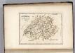
1 : 90500 Bistriţa-Năsăud (Rumunsko : judet)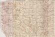
Lambert-Cholesky sheet 3873 (Vf. Izvorul Călimanului)
1 : 20000 Romanian military topographic map sheet under Lambert-Cholensky projection Neprecizat geo-spatial.org Neprecizat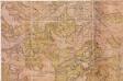
Lambert-Cholesky sheet 3874 (Coverca)
1 : 20000 Romanian military topographic map sheet under Lambert-Cholensky projection Neprecizat geo-spatial.org Neprecizat
Lambert-Cholesky sheet 3872 (Bâtca Mogoşului)
1 : 20000 Romanian military topographic map sheet under Lambert-Cholensky projection Serviciul Geografic al Armatei geo-spatial.org Serviciul Geografic al Armatei

Belbor (Rumanien).
from Spezialkarte der osterreichisch-ungarischen Monarchie.
Besztercze [Bistritz] (Ungarn).
from Spezialkarte der osterreichisch-ungarischen Monarchie.
Bukowina oder oestreich'scher Antheil der Moldau
1 : 580000 Bukovina (Rumunsko a Ukrajina) Küstel, Aloys J. Mare, Carl Gleditsch
Wurzland
Mollova mapová sbírka Hoffmann, Johannes Hoffmann, Johann
[Střední Rumunsko]
1 : 420600 Rumunsko Schraembl, Franz Anton F.A. Schraembl
Siebenbürgen
Sedmihradsko (Rumunsko) Kipferling, Karl Joseph im Verlage des Kunst und Industrie Comptoir's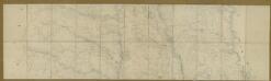
Carte de la Moldavie
1 : 330000 Moldawien, Bessarabien
Kolozsvár (Klausenburg), Máramaros-Sziget, Tölgyes
1 : 750000 Cluj-Napoca (Rumunsko) Erben, F. K. u. k. Militärgeographisches Institut
Kolozsvár (Klausenburg), Máramaros-Sziget, Tölgyes
1 : 750000 Cluj-Napoca (Rumunsko) Erben, F. K. u. k. Militärgeographisches Institut
Klausenburg, Máramaros-Sziget, Tölgyes
1 : 750000 K. u. k. militär-geographisches Institut
Klausenburg, Máramaros-Sziget, Tölgyes
1 : 750000 Cluj-Napoca (Rumunsko) K. k. militär-geographisches Institut
Carte de la Roumanie et pays limitrophes. Klausenbourg
1 : 500000 France. Service géographique de l'armée [Paris] : Service géographique de l'armée
Generalkarte Von Siebenbürgen. Nach geometrisch gemessenen Karten und andern zuverlaessigen Hilfsmitteln verjüngt, und graduirt von Herrn A. von Wenzely. Herausgegeben von Herrn F. A. Schraembl
1 : 430000 Siebenbürgen Produkt, Straßennetz Wenzely, Anton; Schraembl, Franz Anton
Übersichtskarte von Mittel - Europa

Bez titulu: Šest listů speciálních map Ukrajiny
Switzerland.
1 : 1500000 Carey, Mathew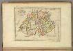
Switzerland.
1 : 1450000 Carey, Mathew
Switzerland.
1 : 1500000 Carey, Mathew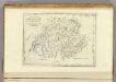
Switzerland.
1 : 500000 Carey, Mathew


