Maps of Gherla

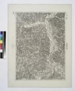
Szamosujvar.; Spezialkarte der osterreichisch-ungarischen Monarchie.
from Spezialkarte der osterreichisch-ungarischen Monarchie. Austro-Hungarian Monarchy. Militärgeographisches Institut.,
Szamosojvár
1 : 75000 Gherla, Judeţ Klausenburg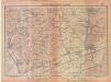
Lambert-Cholesky sheet 3174 (Reteag)
1 : 20000 Romanian military topographic map sheet under Lambert-Cholensky projection Institutul Geografic Militar geo-spatial.org Institutul Geografic Militar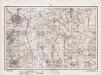
Lambert-Cholesky sheet 3173 (Dej)
1 : 20000 Romanian military topographic map sheet under Lambert-Cholensky projection Direcția Topografică Militară geo-spatial.org Direcția Topografică Militară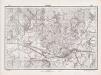
Lambert-Cholesky sheet 3274 (Beclean)
1 : 20000 Romanian military topographic map sheet under Lambert-Cholensky projection Direcția Topografică Militară geo-spatial.org Direcția Topografică Militară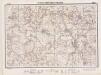
Lambert-Cholesky sheet 3273 (Mălin)
1 : 20000 Romanian military topographic map sheet under Lambert-Cholensky projection Direcția Topografică Militară geo-spatial.org Direcția Topografică Militară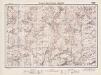
Lambert-Cholesky sheet 3272 (Bozieș)
1 : 20000 Romanian military topographic map sheet under Lambert-Cholensky projection Direcția Topografică Militară geo-spatial.org Direcția Topografică Militară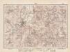
Lambert-Cholesky sheet 3172 (Gherla)
1 : 20000 Romanian military topographic map sheet under Lambert-Cholensky projection Direcția Topografică Militară geo-spatial.org Direcția Topografică Militară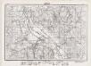
Lambert-Cholesky sheet 3373 (Chintelnic)
1 : 20000 Romanian military topographic map sheet under Lambert-Cholensky projection Direcția Topografică Militară geo-spatial.org Direcția Topografică Militară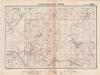
Lambert-Cholesky sheet 3374 (Mogoșeni)
1 : 20000 Romanian military topographic map sheet under Lambert-Cholensky projection Direcția Topografică Militară geo-spatial.org Direcția Topografică Militară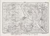
Lambert-Cholesky sheet 3372 (Lechința)
1 : 20000 Romanian military topographic map sheet under Lambert-Cholensky projection Direcția Topografică Militară geo-spatial.org Direcția Topografică Militară
Magyar-Lapos und Makod.
from Spezialkarte der osterreichisch-ungarischen Monarchie.
Besztercze [Bistritz] (Ungarn).
from Spezialkarte der osterreichisch-ungarischen Monarchie.
Alparet [Olpret].
from Spezialkarte der osterreichisch-ungarischen Monarchie.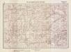
Lambert-Cholesky sheet 3073 (Jichișul De Sus)
1 : 20000 Romanian military topographic map sheet under Lambert-Cholensky projection Serviciul Geografic al Armatei geo-spatial.org Serviciul Geografic al Armatei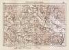
Lambert-Cholesky sheet 3074 (Vad)
1 : 20000 Romanian military topographic map sheet under Lambert-Cholensky projection Serviciul Geografic al Armatei geo-spatial.org Serviciul Geografic al Armatei
Siebenbürgen
1 : 600000 Siebenbürgen
Siebenbürgen
Sedmihradsko (Rumunsko) Kipferling, Karl Joseph im Verlage des Kunst und Industrie Comptoir's
Kolozsvár (Klausenburg), Máramaros-Sziget, Tölgyes
1 : 750000 Cluj-Napoca (Rumunsko) Erben, F. K. u. k. Militärgeographisches Institut
Kolozsvár (Klausenburg), Máramaros-Sziget, Tölgyes
1 : 750000 Cluj-Napoca (Rumunsko) Erben, F. K. u. k. Militärgeographisches Institut
Klausenburg, Máramaros-Sziget, Tölgyes
1 : 750000 K. u. k. militär-geographisches Institut
Klausenburg, Máramaros-Sziget, Tölgyes
1 : 750000 Cluj-Napoca (Rumunsko) K. k. militär-geographisches Institut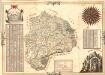
Mapa Particvlaris Transilvaniae
Mollova mapová sbírka Geyer
Transylvaniae Principatus
1 : 720000 Mollova mapová sbírka Seutter, Matthäus Seutter, Matthäus
Nova Transilvaniae Principatus Tabula. Novissima descriptia editia
1 : 730000 Mollova mapová sbírka Ottens, Reinier Ottens, Josua
Principatus Transilvaniae
1 : 720000 Mollova mapová sbírka Homann, Johann Baptist Homann, Johann Baptista
Carte de la Roumanie et pays limitrophes. Klausenbourg
1 : 500000 France. Service géographique de l'armée [Paris] : Service géographique de l'armée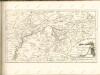

Übersichtskarte von Mittel - Europa