Maps of Pölstal

St. Johann am Tauern.
from Spezialkarte der osterreichisch-ungarischen Monarchie.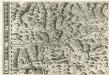
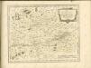
Stÿriae Ducatus Fertilisimi Nova Geographica Descriptio
1 : 200000 Mollova mapová sbírka Vischer, Georg Matthaeus Trost, Andreas
Judenburg.
from Spezialkarte der osterreichisch-ungarischen Monarchie.
Admont und Hieflau.
from Spezialkarte der osterreichisch-ungarischen Monarchie.
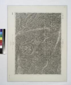
Geologische Karte der Umgebungen von Leoben und Judenburg
1 : 144000 Morlot, Adolph von David
Grobming und St. Nicolai.
from Spezialkarte der osterreichisch-ungarischen Monarchie.
Leoben und Bruck a.d. Mur.
from Spezialkarte der osterreichisch-ungarischen Monarchie.
Archiducatus Austriae Superioris Geographica Descriptio. facta Anno 1667
1 : 150000 Mollova mapová sbírka Vischer, Georg Matthaeus Küssel, Melchior
Neueste special Karte des Judenburger Kreises im Herzogthume Steyermark
1 : 210000 Štýrsko (Rakousko) Kaiser, Jos. Fr. Jos. Fr. Kaiser
Neueste special Karte des Judenburger Kreises im Herzogthume Steyermark
1 : 216000 Štýrsko (Rakousko) Kaiser, Joseph Franz Jos. Fr. Kaiser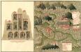
Plan des C. und 5. Bergwerg St. Ulrich an Unter Frauen Bach in Hutthal, in Unter Carnt;
Mollova mapová sbírka Geyer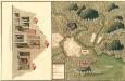
Plan des in Ober Carnten Gold Bergwergs Velach
Mollova mapová sbírka Geyer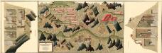
Plan des silber und blei Bergwergs Drul und Mitterdorf, in ober Crain Freiherrn von Rastern
Mollova mapová sbírka Geyer
Der westliche Theil von Obersteyermark oder der Judenburger Kreis
1 : 250000 Horní Rakousko (Rakousko) Kindermann, Joseph Karl Junker, Christoph Franz Xaver Miller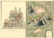
Plan des Bergwergs Nabloch und Hirn
Mollova mapová sbírka Geyer
Generalkarte von Zentraleuropa

Archiducatus Austriae Superioris. Ober Österreich
1 : 550000 Mollova mapová sbírka Suttinger, Johann Baptist Merian, Matthäus
Carinthia Ducatus distincta in Superiorem et Inferior
1 : 360000 Mollova mapová sbírka Seutter, Matthäus
Vermehrte und Verbesserte Landkarten des Königreichs Ungarn :
1 : 500000 Mollova mapová sbírka Stier, Martin Böner, Johann-Alexander Endter, Martin
Kronland Steyermark
1 : 600000 Štýrsko (Rakousko) C. Flemming
Carinthia ducatus distincta in superiorem et inferior
1 : 350000 Korutansko (Rakousko) Lotter, Tobias Conrad T. C. Lotter
Carinthia ducatus distincta in superiorem et inferior
1 : 350000 Korutansko (Rakousko) Lotter, Tobias Conrad T. C. Lotter
Carinthia ducatus distincta in superiorem et inferior
1 : 350000 Korutansko (Rakousko) Lotter, Tobias Conrad per Tobiam Conradum Lotter
Carinthia ducatus distincta in superiorem et inferior
1 : 350000 Korutansko (Rakousko) Lotter, Tobias Conrad per Tobiam Conradum Lotter
S.R.I. principatvs et archiepiscopatus Salisburgensis cum subjetis, insertis, ac finitimis regionibus
1 : 440000 Salcburk-oblast (Rakousko) Homann, Johann Baptist Ioh. Bapt. Homann
S. R. I. principatvs et archiepiscopatus Salisburgensis cum subjectis, insertis, ac finitimis regionibus
1 : 440000 Salcburk-oblast (Rakousko) Homann, Johann Baptist Harrach, František Antonín Ioh. Bapt. Homann
ARCHIDVCATVS | AVSTRIÆ | SVPERIORIS | Vulgo | SVPRA ANISVM | cognominatio
NOVA DESCRIPTIO | Juxta accuratissimas di- | mensionis | ABRAHAMI HOLZ- | WORMII. [Amsterdam : Joan Blaeu]
Murau 159, uit: Special-Karte von Mittel-Europa / nach amtlichen Quellen bearbeitet von W. Liebenow
1 : 300000 titelvariant: W. Liebenow's Mittel-Europa; Annotatie: Titel boven de bladen: W. Liebenow's Mittel-Europa Johannes Wilhelm Liebenow 1822-1897 Frankfurt a. M. : Ludwig Ravenstein