Maps of Suceava

Maps of Suceava

$title$

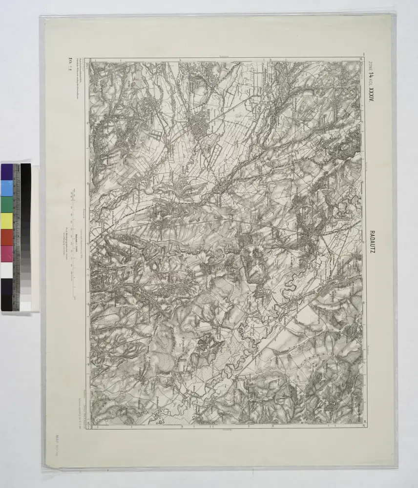
Radautz.; Spezialkarte der osterreichisch-ungarischen Monarchie.

from Spezialkarte der osterreichisch-ungarischen Monarchie. Austro-Hungarian Monarchy. Militärgeographisches Institut.,
$title$

Lambert-Cholesky sheet 4282 (Siret)

1 : 20000 Romanian military topographic map sheet under Lambert-Cholensky projection Direcția Topografică Militară geo-spatial.org Direcția Topografică Militară
$title$

Lambert-Cholesky sheet 4281 ( Şerbǎuţi)

1 : 20000 Romanian military topographic map sheet under Lambert-Cholensky projection Serviciul Geografic al Armatei geo-spatial.org Serviciul Geografic al Armatei
$title$

Lambert-Cholesky sheet 4182 (Hadicfalva)

1 : 20000 Romanian military topographic map sheet under Lambert-Cholensky projection Serviciul Geografic al Armatei geo-spatial.org Serviciul Geografic al Armatei
$title$

Lambert-Cholesky sheet 4181 (Rădăuţi)

1 : 20000 Romanian military topographic map sheet under Lambert-Cholensky projection Serviciul Geografic al Armatei geo-spatial.org Serviciul Geografic al Armatei
$title$

Bez titulu: III – H – d (Rumunsko)

$title$

Lambert-Cholesky sheet 4283 (Mihăileni)

1 : 20000 Romanian military topographic map sheet under Lambert-Cholensky projection Direcția Topografică Militară geo-spatial.org Direcția Topografică Militară
$title$

Lambert-Cholesky sheet 4381 (Vatra)

1 : 20000 Romanian military topographic map sheet under Lambert-Cholensky projection Serviciul Geografic al Armatei geo-spatial.org Serviciul Geografic al Armatei
$title$

Lambert-Cholesky sheet 4382 (Văculeşti)

1 : 20000 Romanian military topographic map sheet under Lambert-Cholensky projection Serviciul Geografic al Armatei geo-spatial.org Serviciul Geografic al Armatei
$title$

Lambert-Cholesky sheet 4180 (Arbora)

1 : 20000 Romanian military topographic map sheet under Lambert-Cholensky projection Serviciul Geografic al Armatei geo-spatial.org Serviciul Geografic al Armatei
$title$

Lambert-Cholesky sheet 4280 (Hatna)

1 : 20000 Romanian military topographic map sheet under Lambert-Cholensky projection Serviciul Geografic al Armatei geo-spatial.org Serviciul Geografic al Armatei
$title$

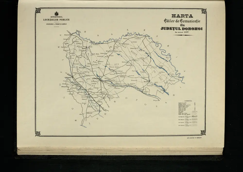
Harta Cailor de Comunicatie din Judetul Dorohoi

Rumänien Judeţ Dorohoi Verkehrsweg
$title$

$title$

$title$

Suczawa.

from Spezialkarte der osterreichisch-ungarischen Monarchie.
$title$

Lambert-Cholesky sheet 4383 (Dorohoi)

1 : 20000 Romanian military topographic map sheet under Lambert-Cholensky projection Serviciul Geografic al Armatei geo-spatial.org Serviciul Geografic al Armatei
$title$

Lambert-Cholesky sheet 4380 (Hănteşti)

1 : 20000 Romanian military topographic map sheet under Lambert-Cholensky projection Serviciul Geografic al Armatei geo-spatial.org Serviciul Geografic al Armatei
$title$

Lambert-Cholesky sheet 4082 (Vicovul De Sus)

1 : 20000 Romanian military topographic map sheet under Lambert-Cholensky projection Serviciul Geografic al Armatei geo-spatial.org Serviciul Geografic al Armatei
$title$

Lambert-Cholesky sheet 4081 (Marginea)

1 : 20000 Romanian military topographic map sheet under Lambert-Cholensky projection Institutul Geografic Militar geo-spatial.org Institutul Geografic Militar
$title$

Bukowina oder oestreich'scher Antheil der Moldau

1 : 580000 Bukovina (Rumunsko a Ukrajina) Küstel, Aloys J. Mare, Carl Gleditsch
$title$

G. Freytags Karte der Bukowina

1 : 400000 Bukovina (Rumunsko a Ukrajina) Freytag, Gustav Kartogr. Anstalt G. Freytag & Berndt
$title$

G. Freytags Karte der Bukowina

1 : 400000 Bukovina (Rumunsko a Ukrajina) Freytag, Gustav G. Freytag & Berndt
$title$

Neue Generalkarte des Österr.-ungar.-russischen Kriegsschauplatzes

$title$

Russia

Mollova mapová sbírka Hoffmann, Johannes Hoffmann, Johann
$title$

$title$

Kolozsvár (Klausenburg), Máramaros-Sziget, Tölgyes

1 : 750000 Cluj-Napoca (Rumunsko) Erben, F. K. u. k. Militärgeographisches Institut
$title$

Kolozsvár (Klausenburg), Máramaros-Sziget, Tölgyes

1 : 750000 Cluj-Napoca (Rumunsko) Erben, F. K. u. k. Militärgeographisches Institut
$title$

Klausenburg, Máramaros-Sziget, Tölgyes

1 : 750000 K. u. k. militär-geographisches Institut
$title$

Klausenburg, Máramaros-Sziget, Tölgyes

1 : 750000 Cluj-Napoca (Rumunsko) K. k. militär-geographisches Institut
$title$

© MapTiler © OpenStreetMap contributors
How does it work?
These instructions will show you how to find historical maps online.
Getting started
Type the place name in the search box to find the exact location. You can further adjust the search by zooming in and out.
Zoom
Zoom in and out with the buttons or use your mouse or touchpad natively.
Exact Area tool
Click here and draw a rectangle over the map to precisely define the search area.
Set filters
Narrow your search with advanced settings, such as Years (from/to), Fulltext, Publisher, etc.
Results
See the results of your search on the right side. You can scroll down to find more maps of this location.
?

Download OldMapsOnline Mobile