Maps of District of Dunajská Streda

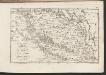
Wartberg und Tallos (Ungarn).
from Spezialkarte der osterreichisch-ungarischen Monarchie.
Zone 13, Kol. XVII, Umgebung von Szempcz und Tallós, uit: [Geologische Specialkarte der im Reichsrathe vertretenen Königreiche und Länder der österreichisch-ungarischen Monarchie] / geologische Aufnahmen der königl. ung. Geologischen Anstalt
1 : 75000 Annotatie: Verantwoordelijkheidsvermelding in 1909 veranderd in: Königliche Ungarische Geologische Reichsanstalt; Sommige bladen in het Frans; Annotatie geografische gegevens: Coördinaten gebaseerd op nulmeridiaan van Ferro (Hierro) Königliche Ungarische Geologische Reichsanstalt; Königliche Ungarische Geologische Anstalt Budapest : [Königliche Ungarische Geologische Anstalt]
Senec
1 : 75000 Senec-oblast (Slovensko) Vojenský zeměpisný ústav
Senec
1 : 75000 Senec (Slovensko : oblast) Vojenský zeměpisný ústav
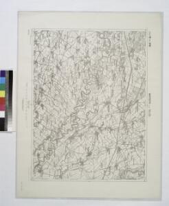
Wartberg und Tallós
1 : 75000 Senec, Tomášikovo Geripp: Oberjgr. Spaczek. Terrain: J. Le Gay Edler v. Lierfels
III. vojenské mapování 4759
1 : 75000
III. vojenské mapování 4759/4
1 : 25000
III. vojenské mapování 4759/2
1 : 25000
III. vojenské mapování 4759/1
1 : 25000
III. vojenské mapování 4759/3
1 : 25000
III. vojenské mapování 4759/1
1 : 25000
III. vojenské mapování 4859/1
1 : 25000
III. vojenské mapování 4859/2
1 : 25000
COMITATVS POSONIENSIS Germanis PRESBVRG dicti Delineatio Geographica
1 : 113000 Bratislava-oblast (Slovensko) Mikoviny, Sámuel curantibus] Homannianis [Heredibus
Poszony vármegye térképe
1 : 300000 Bratislava (Slovensko : oblast) Kogutowicz, Manó Magyar Földrajzi Intézet
Bratislava okolie
C. Posoniensis. Tab. II
Slowakei Komitat Preßburg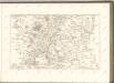

III. vojenské mapování 4658/4
1 : 25000
Petronell - Raab
Mollova mapová sbírka Marsili, Luigi Ferdinando
Tyrnau.
from Spezialkarte der osterreichisch-ungarischen Monarchie.
Duna-Szerdahely und Hedervar.
from Spezialkarte der osterreichisch-ungarischen Monarchie.
Sellye und Nagy-Surany.
from Spezialkarte der osterreichisch-ungarischen Monarchie.
III. vojenské mapování 4760/1
1 : 25000
Presburg mit seinen Umgebungen
Bratislava-oblast (Slovensko) Zutz, Joseph
III. vojenské mapování 4859
1 : 75000
Duna-Szerdehely und Hédervár
1 : 75000 Dunajská Streda, Hédervár Geripp: Oberjgr. Richter. Terrain: Wachtm. R. v. Palitschek
Dunajská Streda
1 : 75000 Dunajská Streda (Slovensko : oblast) Vojenský zeměpisný ústav
Dun. Streda a Hédervár
1 : 75000 Dunajská Streda (Slovensko : oblast) Vojenský zeměpisný ústav
Trnava
1 : 75000 Slovensko Vojenský zeměpisný ústav
Trnava
1 : 75000 Slovensko Vojenský zeměpisný ústav