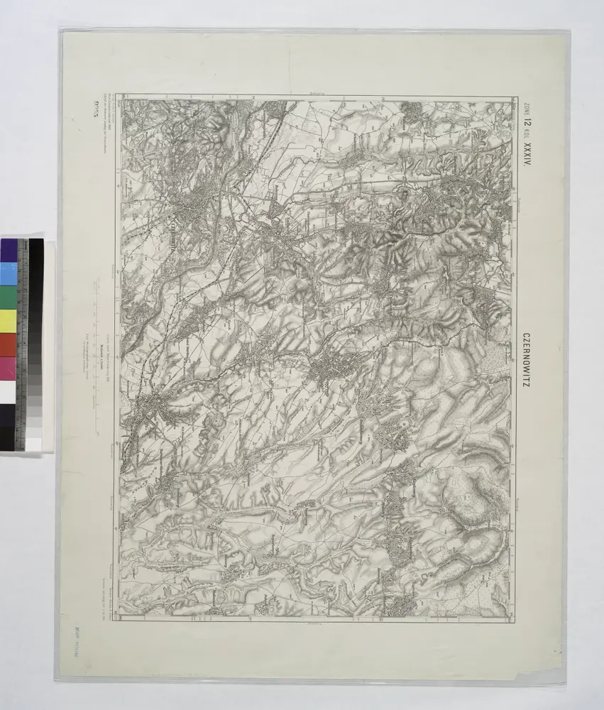
Maps of Novoselytsia Raion

Maps of Novoselytsia Raion

$title$

Czernowitz.

from Spezialkarte der osterreichisch-ungarischen Monarchie.
$title$

Czernowitz

1 : 75000 Ukrajina Leixner, F. K. u. k. Militärgeographisches Institut
$title$

Plan batalii pri Stavučanach v Moldavii, meždu imperatorskoju rossiskoju glavnoju armějeju pod komandoju generala feldtmaršala grafa fon Minicha i meždu tureckoju armějeju, pod komandoju Seraskera trech bunčužnago Veli paši i saltana Islam Girěi, byvšen 17/28 augusta 1739 godu

1 : 40000
$title$

Mielnica.

from Spezialkarte der osterreichisch-ungarischen Monarchie.
$title$

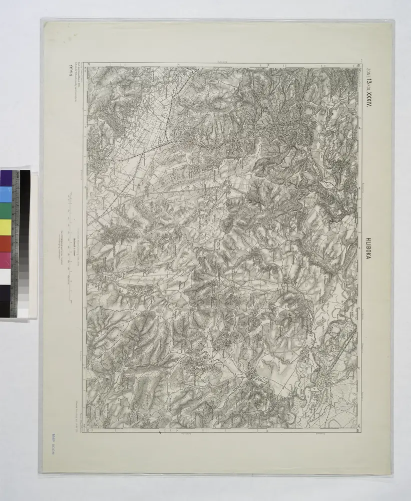
Hliboka.; Spezialkarte der osterreichisch-ungarischen Monarchie.

from Spezialkarte der osterreichisch-ungarischen Monarchie. Austro-Hungarian Monarchy. Militärgeographisches Institut.,
$title$

Lambert-Cholesky sheet 4385 (Orofteana de Sus)

1 : 20000 Romanian military topographic map sheet under Lambert-Cholensky projection Serviciul Geografic al Armatei geo-spatial.org Serviciul Geografic al Armatei
$title$

Ost-Galizien

Halič (Polsko a Ukrajina) Liesganig, Joseph im Verlage des Kunst und Industrie Comptoirs
$title$

Bukowina oder oestreich'scher Antheil der Moldau

1 : 580000 Bukovina (Rumunsko a Ukrajina) Küstel, Aloys J. Mare, Carl Gleditsch
$title$

G. Freytags Karte der Bukowina

1 : 400000 Bukovina (Rumunsko a Ukrajina) Freytag, Gustav Kartogr. Anstalt G. Freytag & Berndt
$title$

G. Freytags Karte der Bukowina

1 : 400000 Bukovina (Rumunsko a Ukrajina) Freytag, Gustav G. Freytag & Berndt
$title$

$title$

$title$

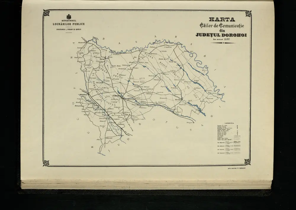
Harta Cailor de Comunicatie din Judetul Dorohoi

Rumänien Judeţ Dorohoi Verkehrsweg
$title$

Mielnica

1 : 75000 Ukrajina Halla, R. K. u. k. Militärgeographisches Institut
$title$

Sniatyn.; Spezialkarte der osterreichisch-ungarischen Monarchie.

from Spezialkarte der osterreichisch-ungarischen Monarchie. Austro-Hungarian Monarchy. Militärgeographisches Institut.,
$title$

Zaleszczyki (Galizien).

from Spezialkarte der osterreichisch-ungarischen Monarchie.
$title$

Kamieniec Podolski.

from Spezialkarte der osterreichisch-ungarischen Monarchie.
$title$

Lipkany

1 : 75000 Moldávie (historické území) Karl, E. K. u. k. Militärgeographisches Institut
$title$

Storozynetz und Dawideny.; Spezialkarte der osterreichisch-ungarischen Monarchie.

from Spezialkarte der osterreichisch-ungarischen Monarchie. Austro-Hungarian Monarchy. Militärgeographisches Institut.,
$title$

Carte de la Moldavie

1 : 330000 Moldawien, Bessarabien
$title$

Neue Generalkarte des Österr.-ungar.-russischen Kriegsschauplatzes

$title$

Ukrainae pars, quae Podolia palatinatus vulgo dicitur / per Guil. le Vasseur de Beauplan s. r. m.tis

1 : 420000 1 Karte : Kupferdruck ; 43 x 52 cm Beauplan, Guillaume le Vasseur de [Verlag nicht ermittelbar]
$title$

Russia

Mollova mapová sbírka Hoffmann, Johannes Hoffmann, Johann
$title$

$title$

$title$

Carte de la Roumanie et pays limitrophes. Lemberg

1 : 500000 France. Service géographique de l'armée [Paris] : Service géographique de l'armée
$title$

Mappa generalis regni Hungariae partiumque adnexarum Croatiae, Slavoniae...

$title$

Galizien, Östlicher Theil und Bukowina

1 : 700000 Bukovina (Rumunsko a Ukrajina) Karl Fr. Pfau
$title$

Sheet X: Karte Des Oesterreichischen Kaiserstaates.

1 : 576000 Scheda, Josef
$title$

X, uit: General-Karte des oesterreichischen Kaiserstaates mit einem grossen Theile der angrenzenden Länder / durch Josef Scheda ... bearb. und hrsg

1 : 576000 Annotatie geografische gegevens: Maatstokken: oesterreichische Meilen, geografische oder deutsche Meilen, preussische Meilen, türkische Berri, französische Lieues, russische Werste; Maatstok per blad: wiener Klafter, öster. Meilen; Blad XIX: statistische en taalkundige informatie; Blad XIX: legenda [Wien : K.K. Militärisch-Geografisches Institut]
© MapTiler © OpenStreetMap contributors
How does it work?
These instructions will show you how to find historical maps online.
Getting started
Type the place name in the search box to find the exact location. You can further adjust the search by zooming in and out.
Zoom
Zoom in and out with the buttons or use your mouse or touchpad natively.
Exact Area tool
Click here and draw a rectangle over the map to precisely define the search area.
Set filters
Narrow your search with advanced settings, such as Years (from/to), Fulltext, Publisher, etc.
Results
See the results of your search on the right side. You can scroll down to find more maps of this location.
?

Download OldMapsOnline Mobile