Maps of District of Malacky

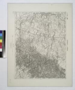
Durnkrut und Bosing.
from Spezialkarte der osterreichisch-ungarischen Monarchie.
III. vojenské mapování 4658
1 : 75000
Malacky
1 : 75000 Malacky-oblast (Slovensko) Vojenský zeměpisný ústav
Malacky
1 : 75000 Malacky (Slovensko : oblast) Vojenský zeměpisný ústav
Malacky
1 : 75000 Malacky (Slovensko : oblast) Vojenský zeměpisný ústav
Dürnkrut und Bösing
1 : 75000 Dürnkrut, Bösing Schrift u. Gerippe v. Feldw. König. Terrainschraffirung v. Lieut. Kuźmin
Eisenbahn Karte Wien-Dresden, Ollmütz-Trübau
1 : 72000 Blatt 2 Minarzik, Anselm J. Rauh
[Kartenblatt]
1 : 25000 Malacky (Slovensko : oblast) Reichsamt für Landesaufnahme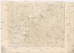
[Kartenblatt]
1 : 25000 Slovensko Reichsamt für Landesaufnahme
III. vojenské mapování 4658/1
1 : 25000
III. vojenské mapování 4658/3
1 : 25000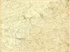
III. vojenské mapování 4658/2
1 : 25000
III. vojenské mapování 4758/2
1 : 25000
Plan zum Treffen bei Blumenau und Pressburg 22. Juli 1866
1 : 30000 Bratislava (Slovensko) Ditfurth, Moritz von des K. u. k. Militärgeographischen Instituts
III. vojenské mapování 4758/1
1 : 25000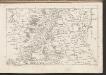
C. Posoniensis. Tab. I
Slowakei Komitat Preßburg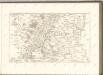

COMITATVS POSONIENSIS Germanis PRESBVRG dicti Delineatio Geographica
1 : 113000 Bratislava-oblast (Slovensko) Mikoviny, Sámuel curantibus] Homannianis [Heredibus
III. vojenské mapování 4658/4
1 : 25000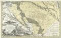
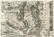
Comitatvs Posoniensis Germanis Presbvrg dicti Delineatio Geographica
1 : 150000 Mollova mapová sbírka Homann, Johann Baptist Alber, Johann Eberhard Homann, Johann Baptista - dědici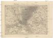
Umgebungen von Hainburg in Oesterreich, und Presburg in Ungarn
1 : 144000 Bratislava-oblast (Slovensko) Müller, A. Withalm, Andreas
Landshut, Sasvar und Hohenau.
from Spezialkarte der osterreichisch-ungarischen Monarchie.
Tyrnau.
from Spezialkarte der osterreichisch-ungarischen Monarchie.
Ganserndorf (Niederosterreich).
from Spezialkarte der osterreichisch-ungarischen Monarchie.
Umgebung von Pozsony
1 : 75000 Bratislava (Slovensko : oblast) K. u. k. Militärgeographisches Institut
Umgebung von Poszony
Archiducatus Austriae inferioris Geographica, et Nouiter Emendata Accuratissima Descriptio :
1 : 153333 Mollova mapová sbírka Vischer, Georg Matthaeus Hoffmann, Jakob
Presburg mit seinen Umgebungen
Bratislava-oblast (Slovensko) Zutz, Joseph
III. vojenské mapování 4758
1 : 75000