Maps of Ivano-Frankivsk Municipality

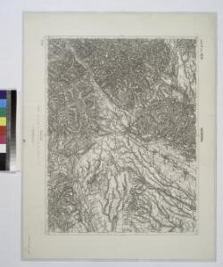
Nadworna (Galizien)
from Spezialkarte der osterreichisch-ungarischen Monarchie.
Nadworna
1 : 75000 Ukrajina Bogdányi, Fr. von K. u. k. Militärgeographisches Institut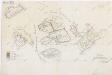
Přehledná mapa revíru Horocholina
1 : 5760

Korosmezo und Mikuliczyn.
from Spezialkarte der osterreichisch-ungarischen Monarchie.
Stanislau (Galizien).
from Spezialkarte der osterreichisch-ungarischen Monarchie.
Porohy.
from Spezialkarte der osterreichisch-ungarischen Monarchie.
Kolomea (Galizien).
from Spezialkarte der osterreichisch-ungarischen Monarchie.
Přehledná mapa naftových polí v okolí Bohorodčan
1 : 25000
Körösmezö und Mikuliczyn
1 : 75000 Jasinja-oblast (Ukrajina) Jonak, Edl. Freyenwald von K. u. k. Militärgeographisches Institut
III. vojenské mapování 4673
1 : 75000
Porohy
1 : 75000 Ukrajina Vojenský zeměpisný ústav
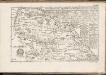
Comitat Marmaros
1 : 288000 Maramureş (Rumunsko)
Comitat Marmaros
1 : 280000 Marmarošská Sihoť (Rumunsko : oblast)
Ost-Galizien
Halič (Polsko a Ukrajina) Liesganig, Joseph im Verlage des Kunst und Industrie Comptoirs
Ukrainae pars quae Pokutia vulgo dicitur / per Guil. le Vasseur de Beauplan S. R. M. Poloniae archit
1 : 310000 1 Karte : Kupferdruck ; 42 x 51 cm Beauplan, Guillaume le Vasseur de [Verlag nicht ermittelbar]
Máramaros vármegye térképe
1 : 500000 Maramureş (Rumunsko) Kogutowicz, Manó Magyar Földrajzi Intézet
Generalkarte von Zentraleuropa
C. Marmarus
Rumänien Komitat Marmarosch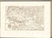

Generalkarte von Zentraleuropa

Kolomea
1 : 75000 Ukrajina Hübner K. u. k. Militärgeographisches Institut
III. vojenské mapování 4572
1 : 75000
Stanislau
1 : 75000 Ivano-Frankivsk-oblast (Ukrajina) Hübner K. u. k. militär-geographisches Institut
Porohy
1 : 75000 Ukrajina Fenzel K. u. k. Militärgeographisches Institut
Brustury
1 : 75000 Ukrajina Vojenský zeměpisný ústav
Kuty (Galizien).
from Spezialkarte der osterreichisch-ungarischen Monarchie.
Brusztura.
from Spezialkarte der osterreichisch-ungarischen Monarchie.
Dolina.
from Spezialkarte der osterreichisch-ungarischen Monarchie.