Maps of Mistelbach District

Mistelbach (Nieder-Osterreich).
from Spezialkarte der osterreichisch-ungarischen Monarchie.
III. vojenské mapování 4557
1 : 75000
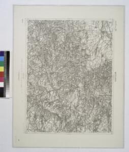
Valtice
1 : 75000 Morava (Česko) Vojenský zeměpisný ústav
Valtice
1 : 75000 Morava (Česko) Vojenský zeměpisný ústav
III. vojenské mapování 4557
1 : 75000

[Gradkartenblatt]
1 : 25000 Dolní Rakousko (Rakousko) Kartographisches Institut
[Gradkartenblatt]
1 : 25000 Dolní Rakousko (Rakousko) Kartographisches Institut
III. vojenské mapování 4557/1
1 : 25000
III. vojenské mapování 4557/2
1 : 25000
[Gradkartenblatt]
1 : 25000 Morava (Česko) Vojenský zeměpisný ústav
[Gradkartenblatt]
1 : 25000 Morava (Česko) Vojenský zeměpisný ústav
Eisenbahn Karte Wien-Dresden, Ollmütz-Trübau
1 : 72000 Blatt 3 Minarzik, Anselm J. Rauh

Hoeflein - m0703-1-001 - Kaiserpflichtexemplar der Landkarten des stabilen Katasters
1 : 2880
Hoeflein - m0703-1-019 - Kaiserpflichtexemplar der Landkarten des stabilen Katasters
1 : 2880
Hoeflein - m0703-1-012 - Kaiserpflichtexemplar der Landkarten des stabilen Katasters
1 : 2880
Hoeflein - m0703-1-014 - Kaiserpflichtexemplar der Landkarten des stabilen Katasters
1 : 2880
Hoeflein - m0703-1-013 - Kaiserpflichtexemplar der Landkarten des stabilen Katasters
1 : 2880
Hoeflein - m0703-1-008 - Kaiserpflichtexemplar der Landkarten des stabilen Katasters
1 : 2880
Hoeflein - m0703-1-018 - Kaiserpflichtexemplar der Landkarten des stabilen Katasters
1 : 2880
Hoeflein - m0703-1-016 - Kaiserpflichtexemplar der Landkarten des stabilen Katasters
1 : 2880
Hoeflein - m0703-1-015 - Kaiserpflichtexemplar der Landkarten des stabilen Katasters
1 : 2880
Hoeflein - m0703-1-002 - Kaiserpflichtexemplar der Landkarten des stabilen Katasters
1 : 2880
Hoeflein - m0703-1-011 - Kaiserpflichtexemplar der Landkarten des stabilen Katasters
1 : 2880
Hoeflein - m0703-1-007 - Kaiserpflichtexemplar der Landkarten des stabilen Katasters
1 : 2880
Hoeflein - m0703-1-003 - Kaiserpflichtexemplar der Landkarten des stabilen Katasters
1 : 2880
Hoeflein - m0703-1-017 - Kaiserpflichtexemplar der Landkarten des stabilen Katasters
1 : 2880
Hoeflein - m0703-1-006 - Kaiserpflichtexemplar der Landkarten des stabilen Katasters
1 : 2880
Hoeflein - m0703-1-009 - Kaiserpflichtexemplar der Landkarten des stabilen Katasters
1 : 2880
Hoeflein - m0703-1-004 - Kaiserpflichtexemplar der Landkarten des stabilen Katasters
1 : 2880
Hoeflein - m0703-1-005 - Kaiserpflichtexemplar der Landkarten des stabilen Katasters
1 : 2880