Maps of Kremenets Raion

Zalozce.
from Spezialkarte der osterreichisch-ungarischen Monarchie.
Załoźce
1 : 75000 Ukrajina Ahl, W. K. u. k. Militärgeographisches Institut
Tarnopol.
from Spezialkarte der osterreichisch-ungarischen Monarchie.
Zloczow.
from Spezialkarte der osterreichisch-ungarischen Monarchie.
Tarnopol
1 : 75000 Ukrajina Ginzkey, K. K. u. k. Militärgeographisches Institut
Neue Generalkarte des Österr.-ungar.-russischen Kriegsschauplatzes

Generalkarte von Zentraleuropa

Generalkarte von Zentraleuropa
General-Karte des Königreiches Galizien und des Herzogthumes Bukovina


Złoczów
1 : 75000 Ukrajina Hanusch, Ed. K. u. k. Militärgeographisches Institut
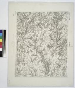
Kremieniec
1 : 75000 Kremenec (Ukrajina) Nikel, L. K. u. k. Militärgeographisches Institut
Pomorzany.
from Spezialkarte der osterreichisch-ungarischen Monarchie.
Jampol
1 : 75000 Schwarz, J. K. u. k. Militärgeographisches Institut
Brody.
from Spezialkarte der osterreichisch-ungarischen Monarchie.
Avstro - Vengrija. Pomožany

Podwołoczyska
1 : 75000 Gottwald, K. K. u. k. Militärgeographisches Institut
Strecke
Ivano-Frankivsk (Ukrajina) K. k. Österreichische Staatsbahnen
Russia
Mollova mapová sbírka Hoffmann, Johannes Hoffmann, Johann
Ost Galizien
Halič (Polsko a Ukrajina) Liesganig, Joseph m Verlage des Kunst- und Industrie- Comptoirs
Tarnopol, Brody, Stryj, Czernowitz
1 : 750000 Brody (Ukrajina) Erben, F. K. u. k. Militärgeographisches Institut
Tarnopol, Brody, Stryj, Czernowitz
1 : 750000 Brody (Ukrajina) Erben, F. K. u. k. Militärgeographisches Institut
Tarnopol, Brody, Stryj, Czernowitz
1 : 750000 K. u. k. militär-geographisches Institut
Tarnopol, Brody, Stryj, Czernowitz
1 : 750000 Brody (Ukrajina) K. k. militär-geographisches Institut
Übrige Länder der ehemaligen Österreich-Ung. Monarchie
1 : 900000 Halič (Polsko a Ukrajina) Koch, Wilhelm Opitz, Carl Arnd
Carte de la Roumanie et pays limitrophes. Lemberg
1 : 500000 France. Service géographique de l'armée [Paris] : Service géographique de l'armée
Augustissimo Romanor. Imperatori Iosepho I. Hungaria Regi Invictissimo Mappam Hanc Regni Hungariae
1 : 540000 Mollova mapová sbírka Müller, Johann Christoph