Maps of okres Znojmo
Soubor map politických okresů
Generální mapa okresních hejtmanství

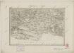
Trebitsch und Mhr. Kromau.
from Spezialkarte der osterreichisch-ungarischen Monarchie.
Geologische Spezialkarte der im Reichsrate vertretenen Königreiche und Länder der Österreichisch-Ungarischen Monarchie
1 : 75000 Moravský Krumlov (Česko : oblast) Suess, Franz Eduard Foetterle, Franz K. k. geologischen Reichsanstalt
Trebitsch und Kromau
1 : 75000 Morava (Česko) Ahl, W. K. u. k. Militärgeographisches Institut
III. vojenské mapování 4356
1 : 75000
Třebíč
1 : 75000 Morava (Česko) Vojenský zeměpisný ústav
Třebíč
1 : 75000 Morava (Česko) Vojenský zeměpisný ústav
Třebíč
1 : 75000 Morava (Česko) Vojenský zeměpisný ústav
Zone 9, Col. XIV, Trebitsch und Kromau, uit: Geologische Karte der im Reichsrathe vertretenen Königreiche und Länder der Österreich-Ungarischen Monarchie : auf Grundlage der Specialkarte i.M. 1:75.000 des k.u.k. Militär-geographischen Institutes / neu bearb. und als Kartenwerk von 341 Blattnummern in zwanglosen Lfg. hrsg. durch die k.k. Geologische Reichsanstalt in Wien
1 : 75000 titelvariant: Geologische Spezialkarte der im Reichsrate vertretenen Königreiche und Länder der Österreichisch-Ungarischen Monarchie; Geologische Specialkarte der im Reichsrathe vertretenen Königreiche und Länder der Österreichisch-Ungarischen Monarchie; Annotatie: Titel bovenaan kaartblad: Geologische Spezialkarte der im Reichsrate vertretenen Königreiche und Länder der Österreichisch-Ungarischen Monarchie en Geologische Specialkarte der im Reichsrathe vertretenen Königreiche und Länder der Österreichisch-Ungarischen Monarchie; Annotatie geografische gegevens: Coördinaten gebaseerd op nulmeridiaan van Ferro (Hierro) Kaiserlich-Königliche Geologische Reichsanstalt, Wenen Wien : K.K. Geologische Reichsanstalt
Geologische Spezialkarte der... Österreichisch-Ungarischen Monarchie... Trebitsch und Kromau
Umgebungen von Brünn
1 : 144000 K.K. Militärisches Geographisches Institut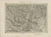
II. vojenské mapování 13
1 : 144000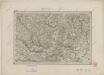
II. vojenské mapování 13
1 : 144000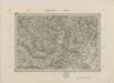
II. vojenské mapování 13
1 : 144000
Znaim.
from Spezialkarte der osterreichisch-ungarischen Monarchie.
Podrobná mapa Markrabství moravského a Vévodství slezského
1 : 100000 Ivančice (Česko : oblast) Srp, Jan Jos. R. Vilímek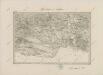
II. vojenské mapování 17
1 : 144000
Podrobná místopisná mapa Království Českého
II. vojenské mapování 17
1 : 144000
Brunn.
from Spezialkarte der osterreichisch-ungarischen Monarchie.
Podrobná mapa Markrabství moravského a Vévodství slezského
1 : 100000 Moravské markrabství Srp, Jan Jos. R. Vilímek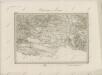
II. vojenské mapování 17
1 : 144000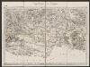
Umgebungen von Znaym
1 : 144000 K.K. Militärisches Geographisches Institut
Státní mapa ČSR


Podrobné mapy zemí Koruny české v měřítku 1:75.000 a mapa vzdáleností všech míst při silnici ležících
1 : 75000 Brno (Česko : oblast) Bělohlav, Josef F. Topič
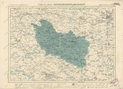
Politický okres brněnský
Vlastivědná sekce učitelstva okresu Brno-venkov
Podrobné mapy zemí Koruny české v měřítku 1:75.000 a mapa vzdáleností všech míst při silnici ležících - Brno. Průvodce statisticko-historický po všech místech na těchto mapách uvedených a rejstřík věcný názvů hor, potoků, řek, rybníků atd. Sešit 5. List 116,
1 : 75000