Maps of okres Liberec

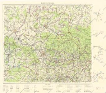
Jizerské hory

Reichenberg u. Friedland.
from Spezialkarte der osterreichisch-ungarischen Monarchie.
Touristen-Karte vom Jeschken- u. Isergebirge
1 : 80000 Ještědský hřbet (Česko) Straube, Julius Matouschek, Josef Paul Sollors Nachf.
Umgebung von Reichenberg
Liberec-oblast (Česko) Biller, Bernhardt Marco Berra
Generální mapa okresních hejtmanství

Mapa okresních hejtmanství Libereckého a Jabloneckého

Generální mapa okresních hejtmanství

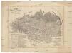
Regni Bohemiae Circulus Boleslaviensis
1 : 210000 Boleslav-oblast (Černousy, Česko) Müller, Johann Christoph ab Homannianis Heredibus
Regni Bohemiae Circulus Boleslaviensis
1 : 210000 Boleslav-oblast (Černousy, Česko) Müller, Johann Christoph in lucem editus ab Homannianis Heredibus
Regni Bohemiae circulus Boleslaviensis
1 : 210000 Boleslav-oblast (Černousy, Česko) Müller, Johann Christoph in lucem editus ab Homannianis Heredibus
Umgebungskarte zu Woerl's Führer
1 : 220000 Liberec-oblast (Česko) Woerl's Reisebücherverlag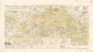
Wegkarte vom Jescken und Isergebirge mit... Teilen des Lausitzer und Riesengebirges

Die Umgegend von Reichenberg
1 : 115200 Liberec-oblast (Česko) Hickmann, Anton L. Verbeek
Karte der Bezirkshauptmannschaften Reichenberg und Gablonz
1 : 100000 Jablonec nad Nisou-oblast (Česko) Erben, Josef Karl Janský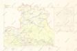
Mapy plánování ČSR

Liberec
1 : 75000 Liberec-oblast (Česko) Vojenský zeměpisný ústav
Liberec
1 : 75000 Liberec (Česko : oblast) Vojenský zeměpisný ústav
Liberec
1 : 75000 Liberec-oblast (Česko) Vojenský zeměpisný ústav
Karte des Bezirkes Reichenberg
Karte der Reichenberger Bezirkshauptmannschaft
1 : 70000 Liberec-oblast (Česko) Medau, Karel Vilém Lehrpersonale der Leitmeritzer k.k. Hauptschule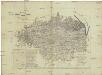
Karte der Reichenberger Bezirkshauptmannschaft
1 : 71000 Liberec-oblast (Česko) Lehrpersonale der Hauptschule
Liberec a okolí
1 : 75000 Liberec (Česko : oblast) Vojenský zeměpisný ústav
Vilímkovy místopisné mapy zemí Koruny české
1 : 100000 Frýdlant (Česko : oblast) Srp, Jan Jos. R. Vilímek
Liberec
1 : 75000 Frýdlant (Česko : oblast) Vojenský zeměpisný ústav
Reichenberg u. Friedland
1 : 75000 Frýdlant (Česko : oblast) Reichenauer K. u. k. Militärgeographisches Institut
Reichenberg u. Friedland
1 : 75000 Frýdlant (Česko : oblast) Reichenauer K. u. k. Militärgeographisches Institut
Reichenberg u[nd] Friedland
1 : 75000 Frýdlant (Česko : oblast) K. u. k. Militärgeographisches Institut
Karte der Bezirkshauptmannschaft Friedland
1 : 100000 Frýdlant-oblast (Česko) Erben, Josef Karl Janský
III. vojenské mapování 3654
1 : 75000