Maps of North Carolina

North Carolina, South Carolina, Georgia and Eastern Tennessee

North Carolina, South Carolina, Georgia.
1 : 1788000 Finley, Anthony
North Carolina, South Carolina, Georgia and Eastern Tenessee

Virginiae partis australis, et Floridae partis orientalis, interjacentiumq[ue] regionum, nova descriptio.
from John H. Levine Collection Meurs, Jacob van; Montanus, Arnoldus,
Virginiae partis australis, et Floridae partis orientalis, interjacentiumq[ue] regionum nova descriptio.
from Parts J. and C. Blaeu: [Amsterdam]; Blaeu, Joan; Blaeu, Willem Janszoon,
Virginiae partis australis et Floridae partis orientalis interjacentimq[ue] regionum, nova descriptio.
from Charts and maps Ioannem Ianssonium?: [Amstelodami?]; Jansson, Jan,
Virginiae partis australis, et Floridae partis orientalis, interjacentiumq[ue] regionum nova descriptio.
from Parts J. and C. Blaeu: [Amsterdam]; Blaeu, Joan; Blaeu, Willem Janszoon,
Virginiae partis australis, et Floridae partis orientalis, interjacentiumq[ue] regionum nova descriptio.
from John H. Levine Collection J. and C. Blaeu: [Amsterdam]; Blaeu, Joan; Blaeu, Willem Janszoon,
Virginiae partis australis, et Floridae partis orientalis, interjacentiumq[ue] regionum nova descriptio.
from Charts and maps J. and C. Blaeu: [Amsterdam]; Blaeu, Joan; Blaeu, Willem Janszoon,
Virginiae partis australis, et Floridae partis orientalis, interjacentiumq[ue] regionum nova descriptio.
from Parts J. and C. Blaeu: [Amsterdam]; Blaeu, Joan; Blaeu, Willem Janszoon,
Carte general de la Caroline: dresse sur les memoires le plus nouveaux
1 : 1300000 Published in N. Sanson's "Atlas Nouveau Contenant Toutes Les Parties du Monde", Paris, 1696, based on the 1685 Thornton-Morden-Lea map. Relief shown pictorially. Depths shown by soundings. Prime meridian: [Cadiz]. Includes inset [scale ca. 1:203,000] of the Ashley and Cooper Rivers, including Charles Town. Sanson, Nicolas, 1600-1667.;Mortier, Pierre. chez Pierre Mortier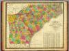
Map of North and South Carolina, and Georgia.
1 : 1800000 Mitchell, Samuel Augustus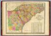
Map Of North and South Carolina And Georgia.
1 : 1750000 Finley, Anthony
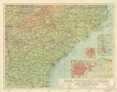
North Carolina, South Carolina, Georgia and eastern Tennessee
1 : 2000000 Charleston (Jižní Karolína) Bumstead, Albert H. National Geographic Society
N. & S. Carolina, Georgia &c.
1 : 2900000 Bowen, Emanuel
Nouvelle carte de la Caroline / par R. Morden.; L'Amerique angloise, ou Description des isles et terres du roi d'Angleterre, dans l'Amérique. Avec de nouvelles cartes de chaque isle & terres. Traduit de l'anglois.
from L'Amerique angloise, ou Description des isles et terres du roi d'Angleterre, dans l'Amérique. Avec de nouvelles cartes de chaque isle & terres. Traduit de l'anglois. Blome, Richard,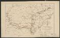
Map showing route of marches of the army of Genl. W.T. Sherman, from Atlanta, Ga. to Goldsboro, N.C. : to accompany the report of operations from Savannah, Ga. to Goldsboro, N.C
1 : 1950000 United States. Army. Corps of Engineers Lith. of P.S. Duval & Son
Virginiae partis australis, et Floridae partis orientalis, interjacentiumque regionum Nova Descriptio. [Karte], in: Theatrum orbis terrarum, sive, Atlas novus, Bd. 2, S. 330.
1 Karte aus Atlas Blaeu, Joan Blaeu, Willem Janszoon
County map of North Carolina, Map of South Carolina, County map of Florida ; Map of Charleston Harbor [inset].
from New general atlas.
VIRGINIÆ | partis australis, | et FLORIDÆ partis | orientalis, interjacentiumque regionum | NOVA DESCRIPTIO.
[Amsterdam : Joan Blaeu]
Virginiae partis australis, et Floridae partis orientalis, interiacentiumque regionum Nova Descriptio. [Karte], in: Le théâtre du monde, ou, Nouvel atlas contenant les chartes et descriptions de tous les païs de la terre, Bd. 2, S. 321.
1 Karte aus Atlas Blaeu, Willem Janszoon und Blaeu, Joan Blaeu, Willem Janszoon
Virginiae item et Floridae Americae Provinciarum, nova descriptio.
The map portrays an area extending from Chesapeake Bay in Virginia to St. Augustine, Florida. Small illustrations of American Indians, local wildlife, ships and sea creatures appear on the map. There is a large rectangular cartouche in the upper left corner with an oval on each side that show differences in the buildings and fortifications between settlements in Florida and Virginia. Captions in lower left and throughout. Mercator, Gerhard, 1512-1594.; Hondius, Hendrik, 1597-1651.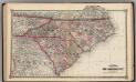
Schonberg's Map of North Carolina and South Carolina.
1 : 1900000 Schonberg & Co.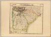
Partie des Etats Unis. Amer. Sep. 57.
1 : 1641836 Vandermaelen, Philippe, 1795-1869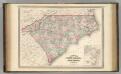
North Carolina and South Carolina.
1 : 1550000 Johnson, A.J.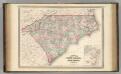
North Carolina and South Carolina.
1 : 1550000 Johnson, A.J.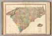
North & South Carolina.
1 : 1100000 Tanner, Henry S.
Virginiae partis australis, et Floridae partis orientalis, interjacentiumque regionum Nova Descriptio. [Karte], in: Novus atlas absolutissimus, Bd. 6, S. 210.
1 Karte aus Atlas Janssonius Offizin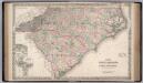
North Carolina and South Carolina.
1 : 1267000 Colton, G.W.