Maps of North Rhine-Westphalia

Übersichtskarte von Mittel - Europa

Übersichtskarte von Mittel - Europa

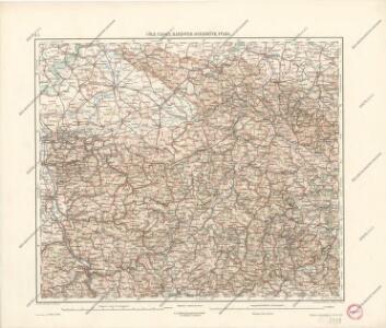
Cöln, Cassel, Hannover, Osnabrück, Fulda
1 : 750000 Fulda (Německo) Lorenz, K. K. u. k. Militärgeographisches Institut
Cöln, Cassel, Hannover, Osnabrück, Fulda
1 : 750000 Fulda (Německo) K. k. militär-geographisches Institut
Operationen der alliirten und französischen Armee 1759
Operations-Karte für die Bewegung der alliirten und der ihr gegenüberstehenden Französischen Armee vom 7ten Februar bis 8ten März.
1 : 600000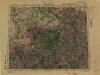
1:500,000 Europe (Air) G.S.G.S. No. 4072, Frankfurt
Sheet NE50-6 from the map series: 1:500,000 Europe (Air) G.S.G.S. No. 4072.
Die Preussische Provinz Sachsen
1 : 600000 Geographisches Institut (Weimar, Germany)
[Vestfálsko]
Vestfálsko (Německo)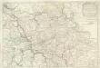
Estats De la Succeßion de Cleves et Iuliers
1 : 860000 Mollova mapová sbírka Sanson, Nicolas Cordier, Robert Sanson, Nicolas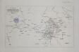
Zur Übersicht der Operationen der alliirten und französischen Armee vom Übergange des Marschall von Broglio über die Weser 24ten Aug. bis zum Ubergange der allirten Armee über diesen Fluss 4ten November 1761
1 : 600000
La Basse Partie Du Cercle Du Haut Rhein divisé en tous ses Estats et Souverainetés [Karte], in: Atlas nouveau, contenant toutes les parties du monde [...], Bd. 1, S. 285.
1 Karte aus Atlas Sanson, Nicolas Jaillot, Alexis Hubert und Mortier, Pieter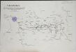
Übersichts-Karte der Operationen der allirten und französischen Armee von Eröffnung des Sommerfeldzuges bis zur Schlacht bei Vellinghausen oder vom Anfang Juni bis 15t Juli 1761
1 : 600000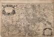
La Basse Partie Du Cercle Du Haut Rhein

Operationen der Alliirten und Französischen Armee 1759

Carte de la Westphalie et de la Hesse
Brémy (Německo : spolková země)
Die preussischen Provinzen Westphalen und Rheinprovinz, das Kurfürstenthum Hessen, das Grossherzogthum Hessen und das Herzogthum Nassau, das Fürstenthum Waldeck, die Landgrafschaft Hessen Homburg und die freie Stadt Frankfurt
1 : 540000 Frankfurt nad Mohanem (Německo) Gräf, A. Luther. Th. Geographisches Institut
Hassiae Desciptio [Karte], in: Theatrum orbis terrarum, S. 134.
1 Karte aus Atlas Ortelius, Abraham
Ducatvs Westphaliae
1 : 270000 Vestfálsko (Německo) Zittart, D. studio Hommanianorum Heredum
Ducatvs Westphaliae
1 : 270000 Vestfálsko (Německo) Zittart, D. studio Hommanianorum Heredum
Deutsch - Französischen Kriegsschauplatzes

Charte von den Kurfürstlich, Grossherzoglich und Landgraeflich Hessischen Ländern, von dem Herzogthume Nassau, den Fürstenthume Waldeck, und dem Gebiethe der freien Stadt Frankfurt
1 : 1625000 entworfen und gezeichnet von F. W. Streit Nürnberg : Campe
Westphalen.
1 : 720000 Flemming, Carl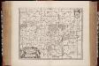
Nova et accurata Moguntini archiepiscopatus delineatio / [Jan Jansson]
1 : 620000 Annotatie: Origineel is Blad 106 in atlas factice; Annotatie geografische gegevens: Schaalstok op de kaart: Milliaria Germanica communia; Oosten boven; Rechtsboven naast wapen: XXXVI Jan Jansson -1655 [Amstelodami] : [Joanni Janssonii haeredes]
Geologische Übersichtskarte der Rheinprovinz und der Provinz Westfalen / bearb. von H. von Dechen
1 : 500000 Heinrich von Dechen Berlin : Schropp
Superior et inferior Hassiae landgraviatus in suos ducatus, comitatus abbatias praefectur accuratissime distinctus
1 : 539000 Hesensko (Německo) Seutter, Matthäus Lotter, Tobias Conrad cura et impensis Mathaei Seutteri
Superior et inferior Hassiae landgraviatus in suos ducatus, comitatus abbatias praefectur accuratissime distinctus
1 : 539000 Hesensko (Německo) Seutter, Matthäus Lotter, Tobias Conrad cura et impensis Mathaei Seutteri
Mappa Circuli Rhenani Superioris
1 : 460000 Mollova mapová sbírka Seutter, Matthäus Seutter, Matthäus
S. R. I. Circulus Rhenanus Superior
1 : 470000 Mollova mapová sbírka Homann, Johann Baptist Homann, Johann Baptista - dědici
S. R. I. Pars Septentrionalior Superioris Circuli Rhenani
1 : 460000 Mollova mapová sbírka Wit, Frederik de Covens, Johannes I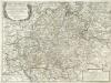
Parte Inferiore Del Circolo Dell' Alto Reno
Mollova mapová sbírka Cantelli, Giacomo Messis, Francesco Donia De Rossi, Giovanni Giacomo