Maps of Czech Republic

Bez titulu: Soubor statistických map Čech
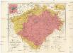
Uibersichtskarte des Königreiches Böhmen
1 : 576000 Jablonec nad Nisou (Česko : oblast) Wagner, Jan Eduard F. Kytka
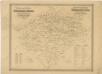
Archäologische Karte des Königreiches Böhmen
Čechy (Česko) Schmitt, Anton Wagner, Jan Eduard Anton Schmitt
Archäologische Karte des Königreiches Böhmen
Čechy (Česko) Schmitt, Anton Wagner, Jan Eduard Anton Schmitt
Archäologische Karte des Königreiches Böhmen
Čechy (Česko) Schmitt, Anton Wagner, Jan Eduard Anton Schmitt
Historisch-geographisch-statistisch-gefaellsaemtliche KARTE vom Königreiche Böhmen
1 : 1040000 Česko Bastien, Joseph Mayregg, Cajetan von Cajetan von Mayregg
Historisch-geographisch-statistisch-gefaellsaemtliche Karte vom Königreiche Böhmen
1 : 1040000 Česko Bastien, Joseph Mayregg, Cajetan von Cajetan von Mayregg
Historisch-geographisch-statistisch-gefaellsaemtliche Karte vom Königreich Böhmen
1 : 1040000 Čechy (Česko) Bastien, Joseph Mayregg, Cajetan von Cajetan von Mayregg
Generální mapa Království českého
1 : 220000 Čechy (Česko) Wagner, Jan Eduard F. Kytka
Přehlední mappa [sic] silnic v Čechách
1 : 680000 Čechy (Česko)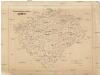
Strassen-Uebersichtskarte von Böhmen
1 : 680000 Čechy (Česko)
Strassenkarte von Böhmen
1 : 441000 Čechy (Česko)
Strassenkarte von Böhmen
1 : 441000 Čechy (Česko)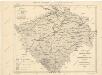
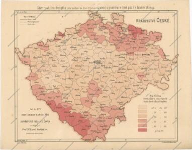
Bez titulu: Soubor statistických map Čech

Sněhová pokrývka v Čechách v zimě 1906-1907
Čechy (Česko) Augustin, František Lhota, J. nákladem České společnosti zeměvědné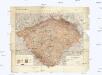
Hydrographische Übersichtskarte des Elbe-Gebietes und des in Böhmen gelegenen Oder-Gebietes
1 : 750000 Labe (Česko a Německo : řeka : povodí) k.k. hydrographisches Central-Bureau
Hydrographische Übersichtskarte des Elbe-Gebietes und des in Böhmen gelegenen Oder-Gebietes
1 : 750000 Labe-povodí (Česko a Německo) k.k. hydrographisches Central-Bureau
Přehledná geologická mapa Království českého
Čechy (Česko) Počta, Filip Lhota, J. nákladem J. Otty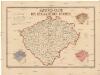
Sanitäts-Carte des Königreiches Böhmen
1 : 606000 Čechy (Česko) Antony, Karl Karl Antony
Entwurf einer statistischen Karte der Maulbeerbaumpflanzungen in Böhmen nach Daten der Bezirksvertrettungen
Čechy (Česko) Patzak, Julius Čeněk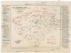
Karte der Wahlkreiseinteilung in Böhmen.
Čechy (Česko) Urban, Karl Lhota, J.
Böhmen
Čechy (Česko)
Böhmen
Čechy (Česko)
Böhmen
1 : 930000 Čechy (Česko) v. C. Flemming
Böhmen
Čechy (Česko) Trampler, Richard Filipovský, Karel v. C. Flemming
Handkarte des königreiches Böhmen
Archeologická mapa království Českého

Sprachenkarte von Böhmen
1 : 500000 Nová Bystřice-oblast (Česko) Rauchberg, Heinrich R. Lechner (Wilh. Müller)
Přírodnická, průmyslnická a zemězpytecká mappa Čech
1 : 864000 Čechy (Česko) Amerling, Karel Porady učitelské v Budči
Přírodní, průmyslnická a zemězpytecká mappa Čech
1 : 864000 Čechy (Česko) Amerling, Karel Porady učitelské v Budči
Přírodnická, průmyslnická a zemězpytecká mappa Čech
1 : 864000 Čechy (Česko) Amerling, Karel Porady učitelské v Budči