Maps of Balkan Pen.

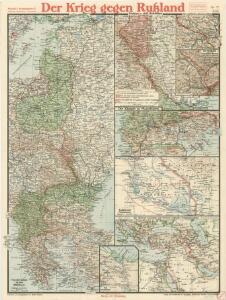
Paasche's Frontenkarte, Nr.17. Der Krieg gegen Russland

Paasche's Frontenkarte, Nr.16. Der Krieg gegen Russland

Paasche's Frontenkarte, Nr.14. Der Krieg gegen Russland

Paasche's Frontenkarte, Nr.15. Der Krieg gegen Russland

Paasche's Frontenkarte, Nr.16. Der Krieg gegen Russland

Paasche's Frontenkarte, Nr.20. Der Krieg gegen Russland

Carte des Etats de la Covronne de Pologne
1 : 3000000 Mollova mapová sbírka Mayer, Tobias Homann, Johann Baptista - dědici
Die Länder des Grössten Völkergemisches
1 : 20000000 Ostmitteleuropa, Südosteuropa
16 bis. Europa etnografica.
1 : 6000000 Touring club italiano
Russie occidentale, Pologne.
1 : 4060000 Brue, Adrien Hubert, 1786-1832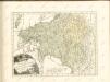
Polonia Et Ungaria, XV. Nova Tabula. [Karte], in: Claud. Ptolemaeus. Geographia lat. cum mappis [...], S. 398.
1 Karte aus Atlas Münster, Sebastian [und Ptolemaeus, Claudius]
Oostelijk operatietooneel
1 : 2250000 Annotatie geografische gegevens: Legenda Den Haag : J. Smulders & Co.
Landtafel des Ungerlands, Polands, Reüssen, Littaw, Walachei und Bulgarei
1 : 4800000 1 Karte : Holzschnitt ; 26 x 34 cm Münster, Sebastian [Bey den Henricpetrinischen]
Landtafel des Ungerlands, Polands, Reüssen, Littaw, Walachei und Bulgarei
1 : 4800000 1 Karte : Holzschnitt ; 26 x 34 cm Münster, Sebastian [Bey den Henricpetrinischen]
Der Balkan
1 : 2000000 Velhagen & Klasing. Firm Bielefeld : Velhagen & Klafing
[Osteuropa]
Evropa východní
Polonia Et Ungaria XX. Nova Tabula. [Karte], in: Claud. Ptolemaeus. Geographia lat. cum mappis [...], S. 422.
1 Karte aus Atlas Münster, Sebastian [und Ptolemaeus, Claudius]
Regni Poloniae magnique ducatusq. Lithuaniae nova et exacta tabula
1 : 3130000 Bělorusko Homann, Johann Baptist Starowolski, Szymon Homannovi dědicové
REGNI POLONIAE MAGNIQUE DUCATUS LITHUANIAE Nova et exacta tabula
1 : 3200000 Bělorusko Homann, Johann Baptist Starowolski, Szymon Homannovi dědicové
Regni Poloniae magnique ducatusq. Lithuaniae nova et exacta tabula
1 : 3130000 Bělorusko Homann, Johann Baptist Starowolski, Szymon Homann Erben
Regni Poloniae magnique ducat[us] Lithuaniae nova et exacta tabula
1 : 3041000 Bělorusko Homann, Johann Baptist Starowolski, Szymon â Iohanne Bapt. Homanno
Russia Occidentale, Pologne Ancien.
1 : 4200000 Levasseur, E.
Polonia Et Ungaria, XV. Nova Tabula. [Karte], in: Geographia universalis vetus et nova complectens Claudii Ptolemaei Alexandrini enarrationis libros VIII, S. 338.
1 Karte aus Atlas Münster, Sebastian [und Ptolemaeus, Claudius]
[Central and southeast Europe]
Evropa jihovýchodní

G. Freytags Karte der westrussischen Kriegsschauplätze
1 : 2000000 Evropa východní Freytag, Gustav G. Freytag & Berndt
Polen vom Anfange des XVIII Jahrhunderts bis zum Untergange der Republik 1795
1 : 5000000 Polen-Litauen, Teilungen Polens
Regni Hungariae, Graeciae, et Moreae, ac regionum, quae ei quondam fuêre christiani, ut Transilvaniae, Valachiae, Moldaviae, Bessarabiae, Bosniae, Sclavoniae, Serviae, Bulgariae, Croatiae, Romaniae, Dalmatiae, Morlachiae, Ragusanae republicae, maximaeq partis Danubii fluminis novissima delineatio
1 : 4000000 1 Karte : Kupferdruck ; 49 x 57 cm Danckerts, Johannes [Danckerts]
Regnum Poloniae eiusque confinia
1 : 11100000 1 Karte : Kupferdruck ; 13 x 17 cm Weigel, Johann Christoph [Johann Christoph Weigel]