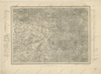
Maps of Novohrad-Volynskyi Raion
g. Volynskoj (Rjad XXII., list 6)

Bez titulu: Šest listů speciálních map Ukrajiny

Generalkarte von Zentraleuropa

Generalkarte von Zentraleuropa

Gouv. 25. Kiew, 27. Pultawa
1 : 2200000 1 Karte : Lithographie ; 19 x 27 cm Schlieben, W.E.A. von [Georg Joachim Göschen]
Speciální mapa západního Ruska

Moscovia
1 : 4500000 1 Karte : Kupferdruck ; 12 x 17 cm Mercator, Gerhard printed by William Stansby for Henrie Fetherstone

Théatre de la guerre actuelle, en Allemagne, en Pologne et en Turquie. n5, Brody
1 : 900000 Chanlaire, Pierre Grégoire 1758-1817 Paris : chez l'auteur P. G. Chanlaire
Gipsometričeskaja karta Polěs'ja s oboznačenijem kanalizacii
1 : 1250000 Polesí
Geologičeskaja karta Polěs'ja
1 : 1250000 Polesí
Li palatinati della Russia rossa Podolia e Wolhynia
1 Karte : Kupferdruck ; 31 x 40 cm Zatta; Zuliani; Pitteri; Rizzi-Zannoni presso Antonio Zatta
Li palatinati della Russia rossa Podolia e Wolhynia / tratta dall'atlante polac[c]o del Sig[no]r Riz
1 : 1500000 1 Karte : Kupferdruck ; 31 x 40 cm Zuliani, Giuliano presso Antonio Zatta
Basse Volhynie, ou palatinat de Kiow / tiré entierement de la gra[n]de Ukraine, du Sieur le Vasseur
1 : 875000 1 Karte : Kupferdruck ; 41 x 56 cm Sanson, Nicolas chez P. Mariette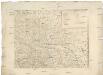
[Západní Ukrajina]
Ukrajina západní Benedicti, Hieronymus
[Střední Ukrajina]
Ukrajina

Österreich-Ungarische Monarchie
1 : 1000000 Evropa jihovýchodní R. Lechner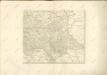

IV, uit: General-Karte von Mittel-Europa in 12 Blättern, im Masse 1:1.200.000 / entworfen, bearb. und hrsg. von Josef Schlacher
1 : 1200000 Annotatie: Blad 6 ontbreekt; Annotatie geografische gegevens: 21 maatstokken op blad 9; Legenda op blad 9 Wien : K.K. Militär Geografisches Institut
VIII, uit: General-Karte von Mittel-Europa in 12 Blättern, im Masse 1:1.200.000 / entworfen, bearb. und hrsg. von Josef Schlacher
1 : 1200000 Annotatie: Blad 6 ontbreekt; Annotatie geografische gegevens: 21 maatstokken op blad 9; Legenda op blad 9 Wien : K.K. Militär Geografisches Institut
Reliefkarte von Galizien und Süd-Polen

Partie, Russie d'Europe. Europe 15.
1 : 1641836 Vandermaelen, Philippe, 1795-1869
Europe Centrale (Partie Orientale).
1 : 1750000 Jouvet et Cie.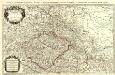
Estats de la Couronne de Boheme
1 : 900000 Mollova mapová sbírka Sanson, Guillaume Jaillot, Alexis Hubert
Danvbivs, Fluvius Europae Maximus
Mollova mapová sbírka Danckertsz, Cornelis Danckerts, Cornelis I. - dědici
Russia in Europe Part V.
1 : 2100000 Society for the Diffusion of Useful Knowledge (Great Britain)
[Sarmatia]
1 : 6630000 1 Karte : Holzschnitt ; 8 x 14 cm Münster, Sebastian [Henricpetri]
Magni dvcatus Lithvaniae ceterarumq[ue] regionum illi adiacentium exacta descrip illss.mi ac excell.mi principis ac dni D. Nicolai Christophori Radziwil D. G. Olycae ac in Nieswies ducis, S. Rom. Imp. principis in Szylowiec ac Mir comitis, et S. Sepulchri Hirosolimitani militis etc
1 : 2000000 Litva Schenk, Pieter P. Schenk et G. Valk