Maps of Alps

Der südwesten der Österreichis - ungarischen Monarchie mit den angrenzenden Gebieten
Bez titulu: Slepá hydrografická mapa jihovýchodní Evropy

[Süd-Östliches Deutschland nebst einem Theile des nördlichen Italien]
Hand-Atlas über alle Theile der Erde und über das Weltgebäude Stieler, Adolf Justus Perthes
Oesterreich, Süd Westlicher Theil
Handatlas über alle Theile der Erde und über das Weltgebäude Stieler, Adolf Justus Perthes
Nejnovější cestovní mapa zemí aplských

Übersichtskarte des südwestlichen Kriegsschauplatzes
1 : 750000 Evropa jihovýchodní k. u. k. Hof- und Universitätsbuchhandlung R. Lechner (W. Müller)
Ost-Alpenländer
Neuer Handatlas über alle Theile der Erde Kiepert, Heinrich Verlag von Dietrich Reimer
[Süd-Östliches Deutschland]
Hand-Atlas über alle Theile der Erde nach dem neuesten Zustande und über das Weltgebäude Stieler, Adolf bei Justus Perthes
Permanente Befestigungen
Győr (Maďarsko) K.k. Generalstabes
Kärnten, Krain, Steiermark, Tirol und Vorarberg
1 : 1750000 Korutansko (Rakousko) F.A. Brockhaus' geogr.-artist. Anstalt
[Süd-Östliches Deutschland, Erzherzogth. Oesterreich, Tirol, Illyrien, Steyermark]
Hand-Atlas über alle Theile der Erde nach dem neuesten Zustande und über das Weltgebäude Stieler, Adolf bei Justus Perthes
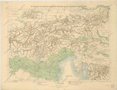
Hypsometrische Uebersichtskarte der Alpen
1 : 1744000 Alpy (pohoří) Steinhauser, Anton Papen, August Artaria
Hypsometrische Uebersichtskarte der Alpen
1 : 1744000 Alpy (pohoří) Steinhauser, Anton Papen, August Artaria
Süd-Östliches Deutschland
Stieler's Hand-Atlas Stieler, Adolf bei Justus Perthes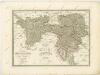
Korutany, Krajina, Salcbursko, Štýrsko, Tyrolsko a Vorarlbersko
Korutansko (Rakousko) Köb, Kajetano Luther, Th. nákladem J. Otty

Géographie. croquis n4, Entre Pô et Danube
1 : 1000000 Molard, Jules, Commandant [Paris] : Service Géographique de l'Armée
Generalcharte von Oesterreich, Tyrol, Steyermark und Illyrien
1 : 1600000 Horní Rakousko (Rakousko) Schönberg, Johann bey Johann Schönberg
Austrian Alps.
1 : 1125000 Andree, Richard; Times (London, England)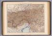
Oesterreich. Alpenlander.
1 : 1125000 Andree, Richard
Die Ostalpenländer
1 : 2750000 Alpenländer Skizzenbuch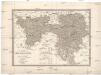
Karte von Tirol, Steyermark und Illyrien
1 : 1174000 Ilýrie Fried, Franz Rothenburg, Friedrich Rudolf von Artaria et Comp.
Der Oesterreichische Kreis
1 : 1380000 Evropa střední Güssefeld, Franz L. Liesganig, Joseph bey den Homannischen Erben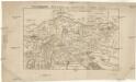
Vindelicien Rhetien und Noricvm
Noricum Baumgarten, Siegmund Jakob Johann Justinus Gebauer
Severovýchodní Italie a alpské země rakouské s Přímořím, Istrii [sic] a Chorvatskem
1 : 1000000 Alpy rakouské-oblast Emil Šolc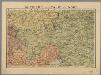
Autriche, Italie du Nord / P. Bineteau del.
1 : 900000 Bineteau, P. Paris : Taride
Der Oesterreichische Kreis
1 : 1340000 Rakousko (1526-1804) Güssefeld, Franz L. Liesganig, Joseph bey Homannischen Erben