Maps of Brandenburg

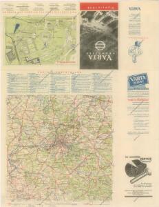
Berlin Varta Wegweiser

Brandenburg.
1 : 1900000 Flemming, Carl
Preussische Provinz Brandenburg
1 : 540000 Berlín-oblast (Německo) Gräf, Adolf Biedermann, E. Geographisches Institut
Provinz Brandenburg
Grosser Hand-Atlas über alle Theile der Erde in 170 Karten Meyer, J. Verlag des Bibliographischen Instituts
Kreise der Provinz Brandenburg 1864
Preußen, Provinz Brandenburg, Verwaltungsgliederung Kunz, Andreas ; Moeschl, Joachim Robert
Die Königl. Preussische Provinz Brandenburg
1 : 625000 Berlín (Německo) Weiland, Karl Ferdinand Verlage des geogr. Instituts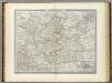
Brandenburg.
1 : 640000 Weiland, C. F. (Carl Ferdinand), d. 1847
Electoratus sive marchia Brandenburgensis
1 : 1500000 accuratae aeri incisa opera et sumptibus Matthaei Seutteri Albrecht Carl Seutter delin. et sculps. August. Vind : [M. Seutter]
Marchia Media; Vulgo Mittel Marck in March: Brandenb: [Karte], in: Novus atlas absolutissimus, Bd. 2, S. 60.
1 Karte aus Atlas Janssonius Offizin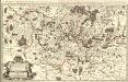
Le Marquisat et Eslectorat de Brandebourg, qui fait partie du Cercle de la Haute Saxe divisé en ses Principales Parties
1 : 490000 Mollova mapová sbírka Sanson, Guillaume Jaillot, Alexis Hubert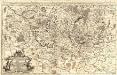
Das Marggraf- und Churfürstenthum Brandenburg
1 : 500000 Mollova mapová sbírka Sanson, Guillaume Hipschmann, Sigmund Gabriel Hoffmann, Johann
Brandenburg.
1 : 920000 Radefeld, Carl Christian Franz, 1788-1874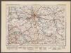
Berlin
1 : 600000 Opitz, Carl Solbrig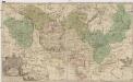
Land-Charte des Chvrfürstenthums Brandenburg
1 : 500000 Braniborsko (Německo) Gundling, Jakob Paul von Busch, Georg Paul G.P. Busch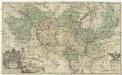
Land-Charte des Chvrfürstenthums Brandenburg
1 : 396000 Braniborsko (Německo) Gundling, Jakob Paul von Busch, G. P. G. P. Busch
Electoratus sive Marchia Brandenburgensis, juxta novissimam Delineationem in mappa Geographica accuratae aeri incisa opera et Sumptibus
1 : 500000 Mollova mapová sbírka Seutter, Matthäus Seutter, Matthäus
Electoratus sive marchia Brandenburgensis juxta novissimam delineationem in mappa geographica, accurate aeri incisa
1 : 548000 Braniborsko (Německo) Seutter, Matthäus sumptibus Mathaei Seutteri
Electoratus sive marchia Brandenburgensis juxta novissimam delineationem in mappa geographica accurate aeri incisa
1 : 548000 Braniborsko (Německo) Seutter, Matthäus Mathaei Seutteri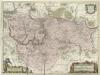
March. Brandenburgici Pars, quae Marchia Media Vulgo Mittesmarck audit
1 : 400000 Mollova mapová sbírka Wit, Frederik de Covens, Johannes I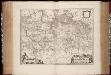
March. Brandenburgici pars, quae Marchia Media vulgo Mittelmarck audit
1 : 400000 Annotatie: Origineel is Blad 91 in atlas factice; Annotatie geografische gegevens: Met schaalstok: Milliaria Germanica Joan Blaeu 1597/98-1673 Amstelaedami : excud. Joannes Blaeu
Marchia Media Vulgo Mittel Marck in March: Brandenb:
1 : 500000 Mollova mapová sbírka Valk, Gerhard Schenk, Peter I
Marchia Media Vulgo Mittel Marck in March: Brandenb:
1 : 510000 Mollova mapová sbírka Janssonius, Johannes Janssonius, Johannes I
Berlin - Leipzig - Wittenberge

[Berlin und Umgebung; Die Donau von Paussau bis Wien mit Umgebung]
Stieler's Hand-Atlas Stieler, Adolf bei Justus Perthes
MARCH. BRANDENBURGICI | PARS, quæ | MARCHIA MEDIA | Vulgo MITTELMARCK audit.
Amstelædami, | Excud. Joannes Blaeu.
Sect. 14: Berlin, uit: Geologische Karte des Deutschen Reichs in 27 Blaettern / [von] Richard Lepsius ; Red. von C. Vogel
1 : 500000 Annotatie: Blad 18 ontbreekt; Een aantal bladen op linnen; Een aantal bladen gereviseerd 1913-1914; Annotatie geografische gegevens: Met schaalstokken o.a. in kilometers; Legenda Carl Vogel 1828-1897 Gotha : Justus Perthes
SAXONIA | SVPERIOR, & | HALL EPISCOPATVS.
Amstelædami J. Blaeu excudebat
Regiae Celsitvdini Sereniss. Principi ac Dno. Frider. Christiano Leopoldo Princ. Pol. et Lith. Reg. Princ. Elect. ac Dvci Sax. Dno. Svo Longe Clementiss. Consistorii Wittebergensis Tabvlam Hanc Geographicam Svmma Mentis Pietate Consecravit Svbiectissimvs
1 : 250000 Mollova mapová sbírka Vierenklee, Johann Ehrenfried Homann, Johann Baptista - dědici
Saxonia Svperior.
1 : 350000 Mollova mapová sbírka Janssonius van Waesberge, Johannes Pitt, Moses