Maps of Tuscany

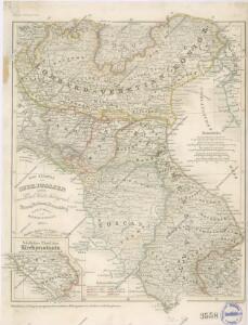
Die Staaten von Oberitalien

Die Staaten von Ober Italien
Itálie severní Stanich, Eugen Rothenburg, R. von Verlag der geographischen Anstalt des Bibliographischen Instituts
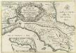
Tableau l'historie des Duches de Toscane, Parma, Modene, Lucques, et du Royme. Lombard-Venetien.
1 : 3100000 Duval, Henri
Uibersichts-Carte der Staaten Toscana, Modena u. Parma mit ihrer neuen Gränzbestim[m]ung
Modena (Itálie)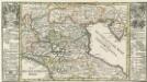
Die Niedere oder Oostliche Lombardia.
1 : 2900000 Mollova mapová sbírka Bodenehr, Gabriel Bodenehr, Gabriel
Composite XI, XII, XVI, XVII: Karte Des Oesterreichischen Kaiserstaates.
1 : 576000 Scheda, Josef
Italy. North Part.
1 : 2450000 Tanner, Henry S.
Italy North Part.
1 : 2450000 Tanner, Henry S.
X, uit: General-Karte von Mittel-Europa in 12 Blättern, im Masse 1:1.200.000 / entworfen, bearb. und hrsg. von Josef Schlacher
1 : 1200000 Annotatie: Blad 6 ontbreekt; Annotatie geografische gegevens: 21 maatstokken op blad 9; Legenda op blad 9 Wien : K.K. Militär Geografisches Institut
Florenz
1 : 1500000 Itálie severní K. u. k. Militärgeograph. Institute
Northern Italy.
1 : 1270000 Mitchell, Samuel Augustus
Northern Italy.
1 : 1270000 Mitchell, Samuel Augustus
Italien. Nördliche Hälfte

Le royaume de France, 6
1 Blatt : 48 x 46 cm Jaillot

Karte des Kriegschauplatzes in Italien
1 : 1800000 Itálie Dittmarsch, C. Trpog.-liter.-artist. Anstalt
Status Ecclesiae et Magni Ducatus Hetruriae
Reyse-Cart von Italien :
1 : 3000000 Mollova mapová sbírka Bodenehr, Gabriel Bodenehr, Gabriel
Specielle Reise-Karte vom Bayerischen Hochland, Nord-Tyrol, Salzburg, und Salzkammergut : mit einer Vergleichenden Höhendarstellung nach den neuesten amtlichen Vermessungen
1 : 500000 Mayr, [Johann] Georg Mayr
Stato Della Chiesa, Con La Toscana. [Karte], in: Theatrum orbis terrarum, sive, Atlas novus, Bd. 3, S. 137.
1 Karte aus Atlas Blaeu, Joan Blaeu, Willem Janszoon
Etat de l'Eglise.
1 : 1500000 Clouet, J. B. L. (Jean-Baptiste Louis), b. 1730
Stato Della Chiesa, Con La Toscana. [Karte], in: Novus Atlas, das ist, Weltbeschreibung, Bd. 3, S. 157.
1 Karte aus Atlas Blaeu, Joan Blaeu, Willem Janszoon
Stato Della Chiesa Con La Toscana [Karte], in: Novus atlas absolutissimus, Bd. 5, S. 142.
1 Karte aus Atlas Janssonius Offizin
Stato Della Chiesa. Dominium Ecclesiasticum In Italia. [Karte], in: Gerardi Mercatoris et I. Hondii Newer Atlas, oder, Grosses Weltbuch, Bd. 2, S. 299.
1 Karte aus Atlas Mercator, Gerhard und Hondius, Jodocus Jansson, Jan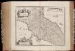
Stato della Chiesa con la Toscana
1 : 1035000 Annotatie: Met opdracht van Henricus Hondius; Origineel is Blad 162 in atlas factice; Annotatie geografische gegevens: Schaalstokken op de kaart: 60 Milliaria Italica communia (=10 cm), en: 12 Milliaria Germanica communia (=8,6 cm) Amstelodami : Sumptibus Ioannis Ianssonii
Stato Della Chiesa, Con La Toscana. [Karte], in: Le théâtre du monde, ou, Nouvel atlas contenant les chartes et descriptions de tous les païs de la terre, Bd. 3, S. 165.
1 Karte aus Atlas Blaeu, Willem Janszoon und Blaeu, Joan Blaeu, Willem Janszoon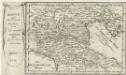
Kleine und Versicherte Karten von der gantzen Lombardia gegen Osten anzusehen
1 : 3000000 Mollova mapová sbírka
Status Ecclesiasticus et magnus ducatus Thoscanae
1 : 800000 per Fredericum de Wit [Amsterdam] : [Frederick de Wit]
STATO DELLA | CHIESA | CON LA TOSCANA
Guiljelmus Blaeu | excudit