Maps of okres Liberec

Bez titulu: Okolí Liberce a Turnova

131. Zittau, uit: Topographische Uebersichtskarte des Deutschen Reiches / herausgegeben v. d. Kartogr. Abt. d. Königl. Preuß. Landesaufnahme
1 : 200000 titelvariant: Topogr. Übersichtskarte des Deutschen Reiches; Annotatie: Titel boven bladen ook: Topogr. Übersichtskarte des Deutschen Reiches; Annotatie geografische gegevens: Op elk blad twee maatstokken: 10 Kilometer = 5,5 cm; 1 geogr. Meile = 3,6 cm; Legenda onder op elk blad Königlich Preußische Landesaufnahme. Kartographische Abtheilung [S.l : Königlich Preußische Landesaufnahme, Kartographische Abtheilung]
Die Umgegend von Reichenberg
1 : 115200 Liberec-oblast (Česko) Hickmann, Anton L. Verbeek
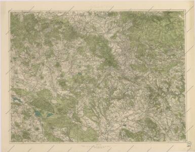
Generalkarte der Bezirkshauptmannschaft Reichenberg
1 : 220000 Liberec-oblast (Česko) Wagner, Jan Eduard F. Kytka
Generalkarte der Bezirkshauptmannschaft Reichenberg
1 : 220000 Liberec-oblast (Česko) Wagner, Jan Eduard F. Kytka
[Umgebung von Reichenberg]
1 : 115200 Liberec-oblast (Česko)
Regni Bohemiae Circulus Boleslaviensis
1 : 210000 Boleslav-oblast (Černousy, Česko) Müller, Johann Christoph ab Homannianis Heredibus
Regni Bohemiae Circulus Boleslaviensis
1 : 210000 Boleslav-oblast (Černousy, Česko) Müller, Johann Christoph in lucem editus ab Homannianis Heredibus
Regni Bohemiae circulus Boleslaviensis
1 : 210000 Boleslav-oblast (Černousy, Česko) Müller, Johann Christoph in lucem editus ab Homannianis Heredibus
Generální mapa okresních hejtmanství

Podrobná mapa Království českého, Markrabství moravského a Vévodství slezského
1 : 100000 Jablonec nad Nisou (Česko : oblast) Srp, Jan Jos. R. Vilímek
Generální mapa okresních hejtmanství

Touristen-Karte vom Jeschken- u. Isergebirge
1 : 80000 Ještědský hřbet (Česko) Straube, Julius Matouschek, Josef Paul Sollors Nachf.
Umgebungskarte zu Woerl's Führer
1 : 220000 Liberec-oblast (Česko) Woerl's Reisebücherverlag
Generální mapa okresních hejtmanství

Generální mapa okresního hejtmanství Turnovského
1 : 220000 Turnov-oblast (Česko) Wagner, Jan Eduard F. Kytka
Mapa okresních hejtmanství Libereckého a Jabloneckého

Turnau.
from Spezialkarte der osterreichisch-ungarischen Monarchie.
[Umgebung von Gabel]
1 : 78000 Jablonné v Podještědí-oblast (Česko) Kreibich, František Jakub Jindřich
Karte des Bezirkes Reichenberg

III. vojenské mapování 3754
1 : 75000
Turnov
1 : 75000 Turnov (Česko : oblast) Vojenský zeměpisný ústav
Umgebung von Jičin
1 : 75000 Jičín (Česko : oblast) K. u. k. militär-geographisches Institut
II. vojenské mapování 3
1 : 144000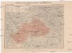
Generální mapa okresního hejtmanství Mnich. Hradištského
1 : 220000 Mnichovo Hradiště-oblast (Česko) Wagner, Jan Eduard F. Kytka
Umgebung von Jičín I.

Liberec a okolí
1 : 75000 Liberec (Česko : oblast) Vojenský zeměpisný ústav
II. vojenské mapování 3
1 : 144000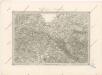
Special - Karte des Koenigreiches Boehmen