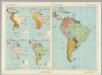
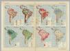
Maps of South America

Charte von Süd - America

Atlas für Industrie- und Handelsgeographie: Für commercielle und technische Lehranstalten, für Kaufleute und Industrielle

Süd America
1 : 16000000 entworfen und gezeichnet von C. F. Weiland gest. v. C. Jungmann Weimar : Verlag des Geograph. Instituts
Süd America
1 : 16000000 entworfen und gezeichnet von C. F. Weiland gest. v. C. Jungmann '29 Weimar : Verlag des Geograph. Instituts
Süd-Amerika
1 : 13000000 Bahamy (souostroví) Handtke, Friedrich Carl Flemming
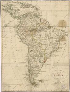
A map of South America with all the European settlements & whatever else is remarkable, from the latest & best observations
1 : 1
Süd America

CHARTE von SÜD-AMERICA
1 : 23900000 Jižní Amerika
Charte von Süd-America
1 : 23900000 Jižní Amerika
Amerique de Sud Politique.
1 : 20000000 Vivien St Martin, L.
Sud-Amerika.
1 : 30000000 Steinmann, G.
Florenkarte von Amerika
Atlas der Pflanzenverbreitung Drude, Oscar Justus Perthes
Amerique de Sud Physique.
1 : 20000000 Vivien St Martin, L.
Composite: Sud-America in zwei Blattern.
1 : 14000000 Stulpnagel, F.v.
South America - political.
1 : 17000000 John Bartholomew and Son
Amerique Meridionale.
1 : 40000000 Levasseur, Victor.
[Süd-Amerika]
Geographischer Atlas über alle Theile der Erde Ziegler, Jakob Melchior Verlag von Joh. Wurster um Comp.
South America.
1 : 22809600 Johnson, A.J.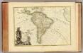
L'Amerique Meridionale.
1 : 31000000 Janvier, Jean
[Neuer Atlas der ganzen Erde nach den neuesten Bestimmungen ... : VI.] Südamerika
Entworfen und gezeichnet von F.W. Streit H. Leutemann sc. Leipzig : J.C. Hinrichs'sche Buchhandlung
Amerique Meridionale
Nicolas de Fer (1646-1720) fue uno de los principales exponentes del desarrollo de la cartografía francesa de principios del siglo XVIII, caracterizada por una orientación estética más sobria y un énfasis en los criterios científicos de la producción cartográfica. Por ello llama la atención que en este mapa del continente suramericano de Fer parece aferrarse a nociones cartográficas desactualizadas a finales del siglo XVIII, como la existencia de un vasto continente en cercanías de la Tierra del Fuego. Fer, Nicolas de (1646-1720) Robbe, Jacques (1643-1721); Guérard, Nicolas, (ca. 1648-1719) Dezallier, Antoine, (1642?-1716)
South America. Pergamon World Atlas.
1 : 60000000 Polish Army Topography Service
Jižní Amerika

221-222. South America, Political. The World Atlas.
1 : 20000000 USSR (Union of Soviet Socialist Republics).
Süd America
Stieler's Hand-Atlas Stieler, Adolf bei Justus Perthes
South America With Improvements To 1823.
1 : 11088000 Tanner, Henry S.
South America : with improvements to 1825
1 : 11000000 Tanner, Henry Schenck, 1786-1858 H.S. Tanner
America Meridionalis [Karte], in: Gerardi Mercatoris Atlas, sive, Cosmographicae meditationes de fabrica mundi et fabricati figura, S. 559.
1 Karte aus Atlas Mercator, Gerhard Montanus, Petrus