Maps of Czech Republic

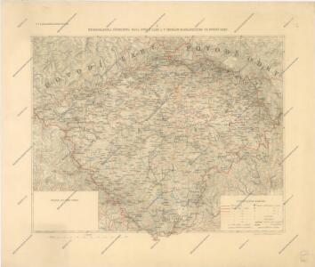
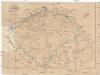
Hydrografická přehledná mapa povodí Labe a v Čechách nacházejícího se povodí Odry

Specielle Telegrafen und Eisenbahnkarte von Böhmen
Strassenkarte des Koenigreiches Boehmen

Hydrographische Karte des Königreiches Böhmen
Železničná [sic] mapa Čech
Čechy (Česko) Kareis, Karel nákladem F. Kytky
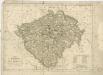
Theatre de la guerre en Boheme...
Eisenbahnkarte von Böhmen
Čechy (Česko) Kareis, Karel von F. Kytka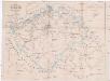
Eisenbahnkarte von Böhmen
Praha (Česko : oblast) Kareis, Karel F. Kytka
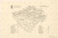
Království česke [sic]
1 : 1500000 Čechy (Česko) Trampler, Richard Filipovský, Karel
Bez titulu: Soubor statistických map Čech

Hydrographische Übersichtskarte des Elbe-Gebietes und des in Böhmen gelegenen Oder-Gebietes

Das Königreich Boehmen
1 : 670000 Česko Weiland, Karl Ferdinand Metzeroth, Carl im Verlage des Geograph. Instituts
Das Königreich Boehmen
1 : 670000 Česko Weiland, Karl Ferdinand Jungmann, J. im Verlage des Geograph. Instituts
Bez titulu: Statistické mapky Čech

Das Königreich Böhmen : nach der neuesten politischen Eintheilungen berichtigt / entw. und gez. von C.F. Weiland
1 : 600000 Weiland, C. F. Weimar : Geograph. Institut
Charte des Königreiches Böhmen...
II. vojenské mapování Klad mapových listů
Eisenbahn-Uebersichtskarte des Königreiches Böhmen

Hydrografická přehledná mapa Čech
Königreich Böhmen

Mappa chorographica novissima et completissima totius regni Bohemiae in duodecim circulos divisae cum comitatu Glacensi et districtu Egerano adiunctis circumiacentium regionum partibus conterminis ex accurata totius regni perlustratione et geometrica dimensione mandato caesareo instituta in hanc formam redacta et ad usum commodum nec non omnia singula distinctius cognoscenda XXV. sectionibus exhibita
1 : 230000 Česko Müller, Johann Christoph Herz, Johann Daniel Michael Kauffer
Mappa Geographica Regni Bohemiae In Duodecim Circulos Divisae
1 : 276000 Česko Müller, Johann Christoph Herz, Johann Daniel Michael Kauffer
Železniční a silniční mapa království Českého

Mappa Geographica totius Regni Bohemiae in XII. Circulos divisae annexis Comitatu Glacensi et Districtu Egerano nec non aliis Principatib; finitimis Noviter et exactissime elaborata
1 : 740000 Mollova mapová sbírka Lotter, Tobias Conrad Lotter, Tobias Conrad
Království české
Česko Fr. Stephan Lotter, Tobias Conrad
Přehledná hydrografická mapa povodí Labe, Odry a Dunaje v Čechách
1 : 750000 Dunaj (řeka : povodí) Vojenský zeměpisný ústav
Přehledná hydrografická mapa povodí Labe, Odry a Dunaje v Čechách
1 : 750000 Dunaj (řeka : povodí) Vojenský zeměpisný ústav
Přehledná hydrografická mapa povodí Labe, Odry a Dunaje v Čechách
1 : 750000 Dunaj-povodí Vojenský zeměpisný ústav
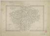
Čechy v VIII. a IX. věku
Čechy (Česko) Vocel, Jan Erazim nákladem král. české společnosti nauk