Maps of Pecka

Stabilní katastr - Procovní otisk Markt Petzka

Petzka (Pecka) - c5677-1-004 - Kaiserpflichtexemplar der Landkarten des stabilen Katasters
1 : 2880
Petzka (Pecka) - c5677-1-003 - Kaiserpflichtexemplar der Landkarten des stabilen Katasters
1 : 2880
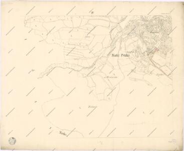
Petzka (Pecka) - c5677-1-001 - Kaiserpflichtexemplar der Landkarten des stabilen Katasters
1 : 2880
Petzka (Pecka) - c5677-1-002 - Kaiserpflichtexemplar der Landkarten des stabilen Katasters
1 : 2880
Bilai (Běla) - c0187-1-001 - Kaiserpflichtexemplar der Landkarten des stabilen Katasters
1 : 2880
Bilai (Běla) - c0187-1-002 - Kaiserpflichtexemplar der Landkarten des stabilen Katasters
1 : 2880
Nieder Jaworz (Dolenj Jawoř) - c1302-1-001 - Kaiserpflichtexemplar der Landkarten des stabilen Katasters
1 : 2880
Nieder Jaworz (Dolenj Jawoř) - c1302-1-002 - Kaiserpflichtexemplar der Landkarten des stabilen Katasters
1 : 2880
Bestandeskarte der Forste Bělohrad
1 : 10000 Lázně Bělohrad (Česko : oblast)
Bestandeskarte der Forste Bjelohrad
1 : 10000 Lázně Bělohrad (Česko : oblast)
Bestandeskarte der Forste Bjelohrad
1 : 10000 Lázně Bělohrad (Česko : oblast)
Bestandeskarte der Forste Bělohrad
1 : 10000 Lázně Bělohrad (Česko : oblast)
Bestandeskarte der Forste Bělohrad
1 : 10000 Lázně Bělohrad (Česko : oblast)
III. vojenské mapování 3855/2
1 : 25000

III. vojenské mapování 3855
1 : 75000
Jičín
1 : 75000 Dvůr Králové nad Labem (Česko : oblast) Vojenský zeměpisný ústav
Hořitz und Jičin
1 : 75000 Dvůr Králové nad Labem (Česko : oblast) Richter K. u. k. militär-geographisches Institut
Hořitz und Jičin
1 : 75000 Dvůr Králové nad Labem (Česko : oblast) Richter K. u. k. Militärgeographisches Institut
Hořitz und Jičin
1 : 75000 Hořice (Jičín, Česko : oblast) K. u. k. Militärgeographisches Institut
Umgebung von Jičín II.

Podrobná mapa Království českého
1 : 100000 Dvůr Králové nad Labem (Česko : oblast) Srp, Jan Jaroslav Bursík
Vilímkovy místopisné mapy zemí Koruny české
1 : 100000 Dvůr Králové nad Labem (Česko : oblast) Srp, Jan Jos. R. Vilímek
[Český ráj]
1 : 75000 Český ráj (Česko) nákladem odboru KČST
Mapa okresního hejtmanství Královéhradeckého
1 : 100000 Hradec Králové-oblast (Česko) Erben, Josef Flemming, C. nákladem Karla Janského
[Trautenau, Königinhof und Umgebung]
1 : 243000 Králův Dvůr (Česko)
Vilímkovy podrobné mapy politických okresů

Karte der Bezirkshauptmannschaften Hohenelbe und Starkenbach
Jilemnice-oblast (Česko) Erben, Josef Flemming, C. Karl Janský