Maps of Lázně Bělohrad

Stabilní katastr - Procovní otisk Mittel Neudorf (Prostřednj - djl - Nowe Wsy)...

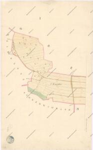
Mittel Neudorf (Prostřednj-Dlj-Nowe Wsy) - c6133-1-001 - Kaiserpflichtexemplar der Landkarten des stabilen Katasters
1 : 2880
Mittel Neudorf (Prostřednj-Dlj-Nowe Wsy) - c6133-1-002 - Kaiserpflichtexemplar der Landkarten des stabilen Katasters
1 : 2880
Mittel Neudorf (Prostřednj-Dlj-Nowe Wsy) - c6133-1-003 - Kaiserpflichtexemplar der Landkarten des stabilen Katasters
1 : 2880
Rzidelec (Řidelec) - c2395-1-002 - Kaiserpflichtexemplar der Landkarten des stabilen Katasters
1 : 2880
Rzidelec (Řidelec) - c2395-1-001 - Kaiserpflichtexemplar der Landkarten des stabilen Katasters
1 : 2880
Rzidelec (Řidelec) - c2395-1-003 - Kaiserpflichtexemplar der Landkarten des stabilen Katasters
1 : 2880
Augezd St.Johann (Augezd Swatojansky) - c7593-1-004 - Kaiserpflichtexemplar der Landkarten des stabilen Katasters
1 : 2880
Augezd St.Johann (Augezd Swatojansky) - c7593-1-001 - Kaiserpflichtexemplar der Landkarten des stabilen Katasters
1 : 2880
Augezd St.Johann (Augezd Swatojansky) - c7593-1-003 - Kaiserpflichtexemplar der Landkarten des stabilen Katasters
1 : 2880
Augezd St.Johann (Augezd Swatojansky) - c7593-1-002 - Kaiserpflichtexemplar der Landkarten des stabilen Katasters
1 : 2880
Ober Neudorf (Horni dil Nowe Wsy) - c2108-1-004 - Kaiserpflichtexemplar der Landkarten des stabilen Katasters
1 : 2880
Ober Neudorf (Horni dil Nowe Wsy) - c2108-1-001 - Kaiserpflichtexemplar der Landkarten des stabilen Katasters
1 : 2880
Ober Neudorf (Horni dil Nowe Wsy) - c2108-1-002 - Kaiserpflichtexemplar der Landkarten des stabilen Katasters
1 : 2880
Ober Neudorf (Horni dil Nowe Wsy) - c2108-1-003 - Kaiserpflichtexemplar der Landkarten des stabilen Katasters
1 : 2880
Ober Neudorf (Horni dil Nowe Wsy) - c2108-1-005 - Kaiserpflichtexemplar der Landkarten des stabilen Katasters
1 : 2880
Bestandeskarte der Forste Bělohrad
1 : 10000 Lázně Bělohrad (Česko : oblast)
Bestandeskarte der Forste Bjelohrad
1 : 10000 Lázně Bělohrad (Česko : oblast)
Bestandeskarte der Forste Bjelohrad
1 : 10000 Lázně Bělohrad (Česko : oblast)
Bestandeskarte der Forste Bělohrad
1 : 10000 Lázně Bělohrad (Česko : oblast)
Bestandeskarte der Forste Bělohrad
1 : 10000 Lázně Bělohrad (Česko : oblast)
[Kartenblatt]
1 : 25000 Jičín (Česko : oblast) Reichsamt für Landesaufnahme
Gradkartenblatt
1 : 25000 Jičín-oblast (Česko) Bellschan, Anton
III. vojenské mapování 3855/1
1 : 25000
Mapa politického a školního okresu Hradce Králové


Jičín a okolí
1 : 75000 Jičín (Česko : oblast) Vojenský zeměpisný ústav
III. vojenské mapování 3855
1 : 75000