Maps of Šárovcova Lhota

Stabilní katastr - Procovní otisk Lhotta - Scharowes...

Lhotta Scharowes - c7702-1-004 - Kaiserpflichtexemplar der Landkarten des stabilen Katasters
1 : 2880
Lhotta Scharowes - c7702-1-003 - Kaiserpflichtexemplar der Landkarten des stabilen Katasters
1 : 2880
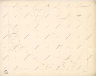
Lhotta Scharowes - c7702-1-001 - Kaiserpflichtexemplar der Landkarten des stabilen Katasters
1 : 2880
Lhotta Scharowes - c7702-1-002 - Kaiserpflichtexemplar der Landkarten des stabilen Katasters
1 : 2880
Hollowaus - c1973-1-004 - Kaiserpflichtexemplar der Landkarten des stabilen Katasters
1 : 2880
Hollowaus - c1973-1-005 - Kaiserpflichtexemplar der Landkarten des stabilen Katasters
1 : 2880
Hollowaus - c1973-1-002 - Kaiserpflichtexemplar der Landkarten des stabilen Katasters
1 : 2880
Hollowaus - c1973-1-003 - Kaiserpflichtexemplar der Landkarten des stabilen Katasters
1 : 2880
Hollowaus - c1973-1-001 - Kaiserpflichtexemplar der Landkarten des stabilen Katasters
1 : 2880
Stabilní katastr - Procovní otisk Lhotta - Scharowes...


[Kartenblatt]
1 : 25000 Jičín (Česko : oblast) Reichsamt für Landesaufnahme
Gradkartenblatt
1 : 25000 Jičín-oblast (Česko) Bellschan, Anton
III. vojenské mapování 3855/1
1 : 25000
Mapa politického a školního okresu Hradce Králové


Jičín a okolí
1 : 75000 Jičín (Česko : oblast) Vojenský zeměpisný ústav
III. vojenské mapování 3855
1 : 75000
Karte des Schlachtfeldes von Königgrätz
1 : 50000 Gerold
Jičín
1 : 75000 Dvůr Králové nad Labem (Česko : oblast) Vojenský zeměpisný ústav
Operations-Karte für die Schlacht bei Königgrätz
1 : 100000 Hradec Králové-oblast (Česko)
Hořitz und Jičin
1 : 75000 Dvůr Králové nad Labem (Česko : oblast) Richter K. u. k. militär-geographisches Institut
Hořitz und Jičin
1 : 75000 Dvůr Králové nad Labem (Česko : oblast) Richter K. u. k. Militärgeographisches Institut
Hořitz und Jičin
1 : 75000 Hořice (Jičín, Česko : oblast) K. u. k. Militärgeographisches Institut
Podrobná mapa Království českého
1 : 100000 Dvůr Králové nad Labem (Česko : oblast) Srp, Jan Jaroslav Bursík
Vilímkovy místopisné mapy zemí Koruny české
1 : 100000 Dvůr Králové nad Labem (Česko : oblast) Srp, Jan Jos. R. Vilímek
Mapa okresního hejtmanství Královéhradeckého
1 : 100000 Hradec Králové-oblast (Česko) Erben, Josef Flemming, C. nákladem Karla Janského