Maps of Southwest

Südlicher Theil von Boehmen...

Karte der Holzartenverbreitung in Protektorat Böhmen und Mähren
Svoboda, Pravdomil
Generální mapa Protektorátu Čechy a Morava

Bez titulu – Wielandova mapa Čech, Moravy a Slezska
Církevní mapa biskupství Budějovického
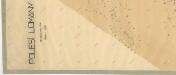
Mapa polesí Lomany
1 : 5000
Uebersichtskarte der k.k. priv. böhmischen Westbahn
1 : 320000 Čechy západní (Česko)
Nejstarší hroby v Čechách
Čechy (Česko)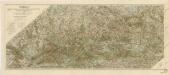
Šumava generální mapa značených cest turistických

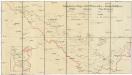
Carte geographique de la nouvelle communication entre le Danube & la Moldau
1 : 700000 Dunaj Sterndahl, Albert de Winkler, Johann Christoph
Carte Geographique de la nouvelle Communication entre le Danube &. la Moldau
Mollova mapová sbírka Sterndahl, Albert von Winkler, Johann Christoph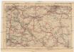
Deutsches Reich, Tschecho-Slowakei
1 : 600000 Německo Koch, Wilhelm Opitz, Carl Arnd
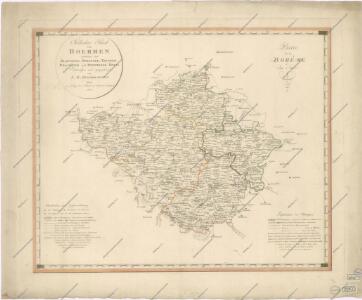
Südlicher Theil von Boehmen enthaltend den Klatttauer, Berauner, Taborer, Prachiner und Budweiser Kreis
Čechy jižní (Česko) Kindermann, Joseph Karl Kunst= und Industrie Comptoir
Südlicher Theil von Boehmen enthaltend den Klattauer, Berauner, Taborer, Prachiner und Budweiser Kreis
Čechy jižní (Česko) Kindermann, Joseph Karl im Verlage des Kunst- und Industrie Comptoirs
Generalkarte von Zentraleuropa

Jihočeský kraj
Allgemeiner Übersichtsplan der böhmischen Kohlenbahn
1 : 347000 Čechy (Česko)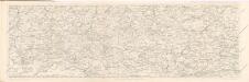
Reisehandbuch für das Königreich Böhmen

Karte des Taborer und Budweiser Kreises im österreichischen Kronlande Böhmen
1 : 285000 Tábor-oblast (Česko) Obentraut, Maxmilian Friedrich Kretzschmar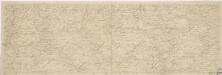
Šumava
Schutzvereins-Ortsgruppen des Böhmerwaldes und Deutsch-Südböhmens
1 : 200000 Čechy jižní (Česko)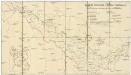
Deutsche Gemeinden u. Pfarren Südböhmens
1 : 200000 Čechy jižní (Česko) Blechinger, L.
Kraj Českobudějovický

[Čechy]
1 : 390000 Čechy (Česko)
Jihočeský kraj

Regni Bohemiae Circuli Taborensis et Budweisensis...

Regni Bohemiae Circulus Bechinensis
1 : 264000 Bechyně-oblast (Česko) Müller, Johann Christoph ab Homannianis Heredibus
Regni Bohemiae Circulus Bechinensis
1 : 264000 Bechyně-oblast (Česko) Müller, Johann Christoph ab Homannianis Heredibus
Industrie-Karte des Pilsner und Piseker Kreises beziehungsweise Pilsner Kammerbezirkes
Plzeň-oblast (Česko)
Industrie-Karte des Pilsner und Piseker Kreises beziehungsweise Pilsner Kammerbezirkes
Plzeň-oblast (Česko)
Industrie-Karte des Pilsner und Piseker Kreises beziehungsweise Pilsner Kammerbezirkes
Plzeň-oblast (Česko)