Maps of Carpathian Mountains
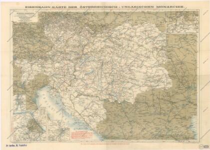
Eisenbahnkarte der österreichisch-ungarischen Monarchie

Eisenbahnkarte von Mittel Europa
1 : 3375000 Berlín (Německo) Broditzky, Joseph R. v. Waldheim
Composite: Austro-Hungarian Monarchy.
1 : 1642000 Johnston, W. & A.K.
Karta Avstro-Vengrii
1 : 520000 Rakousko-Uhersko Il'jin, A.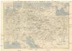
Eisenbahn-Routen-Karte von Mittel-Europa
Budapešť (Maďarsko) Ritter, Julius Broditzky, Joseph R. v. Waldheim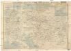
Eisenbahn-Routen-Karte von Mittel-Europa
Budapešť (Maďarsko) Ritter, Julius Broditzky, Joseph R. v. Waldheim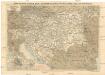
Eisenbahn-Routen-Karte von Mittel-Europa
Budapešť (Maďarsko) Ritter, Julius Broditzky, Joseph R. v. Waldheim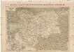
Eisenbahn-Karte der Österreichisch-Ungarischen Monarchie
Rakousko-Uhersko Broditzky, Joseph R. v. Waldheim
Dichtigkeit der deutschen Bevölkerung
Rakousko-Uhersko Doležal, A.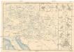
Eisenbahn-Routen-Karte für Österreich-Ungarn
Bratislava (Slovensko) Ritter, J. R. v. Waldheim
Eisenbahn-Routen-Karte für Österreich-Ungarn
Rakousko-Uhersko Ritter, J. R. v. Waldheim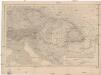
Kaiserthum Oesterreich
1 : 2500000 Rakousko-Uhersko Gräf, Carl Geographisches Institut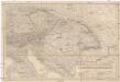
Kaiserthum Oesterreich
1 : 2500000 Rakousko-Uhersko Gräf, Carl Geographisches Institut
Kaiserthum Oesterreich
1 : 2500000 Evropa jihovýchodní Gräf, C. Geographisches Institut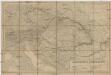
Kaiserthum Oesterreich
1 : 2500000 Evropa jihovýchodní Gräf, C. Geographisches Institut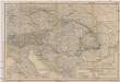
Oesterreichisch-ungarische Monarchie
1 : 2500000 Rakousko-Uhersko Geographisches Institut
Artaria's Eisenbahn- u. Postkarte von Oesterreich-Ungarn
1 : 1500000 Budapešť (Maďarsko) Artaria
Artaria's Eisenbahn- u. Post- Communications-Karte v. Oesterreich-Ungarn
1 : 1700000 Rakousko-Uhersko Skrzeszewski, F. von Artaria & Comp.
Artaria's Eisenbahn- u. Post- Communications-Karte v. Oesterreich-Ungarn
1 : 1700000 Rakousko-Uhersko Skrzeszewski, F. R. Artaria
Artaria's Eisenbahn- u. Post-Communications-Karte v. Oesterreich-Ungarn
1 : 1700000 Budapešť-oblast (Maďarsko) Artaria
Artaria's Eisenbahn- u. Post-Communications-Karte v. Oesterreich-Ungarn
1 : 1700000 Budapešť (Maďarsko) Artaria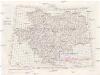
[Jugoslávie 1:200 000]
1 : 25000 Jugoslávie K. u. k Militärgeographisches Institut
Der Österreichische Kaiserstaat
Hand-Atlas über alle Theile der Erde und über das Weltgebäude Stieler, Adolf Justus Perthes
Strassen- und Eisenbahnkarte des oesterreichischen Kaiserthumes
1 : 864000 Rakousko (1804-1867) Schaller, Georg k.k. militärisch-geographisches Institut
Osterreichisch. Ungarische Monarchie.
1 : 3700000 Vogel, C.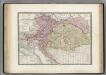
Autriche, Hongrie.
1 : 2800000 Levasseur, E.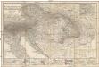
Das Österreichisch-Ungarische Reich
1 : 1850000 Rakousko-Uhersko Berghaus, Hermann Eulenstein, F. Justus Perthes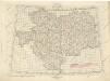
Übersichtblatt der Spezialkarte 1:75 000

Rakousko-Uhersko, mapa národopisná
1 : 2750000 Banát Machát, František J. Otto