Maps of Switzerland
Soubor map

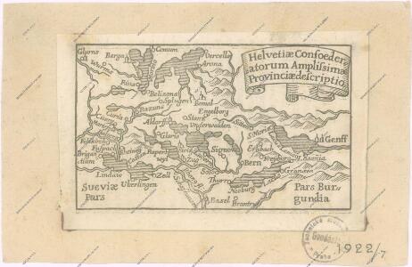
Helvetia
1 : 1900000 1 Karte [Verlag nicht ermittelbar], [Erscheinungsort nicht ermittelbar]
<<Les>> cantons des Suisses et leurs alliéz et leurs sujets
1 : 1400000 1 Karte [Chamereau], [Amsterdam]
[Physische Karte der Schweiz]
1 : 1075000 1 Karte [Verlag nicht ermittelbar], [Erscheinungsort nicht ermittelbar]
<<Die>> gantz Eydgnoschafft
1 : 850000 1 Karte [Johannes Stumpf] [Froschauer], [Zürich]
<<La>> Suisse
1 : 800000 1 Karte nach H.K. [i.e. Heinrich Keller] Hch. Keller's geogr. Verlag, untere Zäune 23, Zürich
<<Die>> XIII Cantons u. Bunds Verwanten der freyen Schweitzer-Republic
1 : 1700000 1 Karte accurat entworffen Elias Bäck à. H. fc. et exc. [Verlag nicht ermittelbar], Augusta Vindelic.
Uebersichts-Karte der Schweiz
1 : 1050000 1 Karte für den Schulgebrauch bearbeitet von Rudolph Gross ; gestochen von Rixinger u. Graf Ch. Beyel, Frauenfeld
<<Die>> Schweiz
1 : 1470000 1 Karte G. Heck dirt. ; R. Schmidt et J. Maedel III sculp. [F.A. Brockhaus], [Leipzig]
Nova totius Helvetiae cum suis subditis ac sociis tab. geogr
1 : 790000 1 Karte studio manu ac sumtibus Matth. Seut. Seutter, [Augsburg]
Carte de Suisse avec ses alliéz et ses sujets et des trois ligues des Grisons et de leurs sujets &c
1 : 1500000 1 Karte par. M. [i.e. David-François de Merveilleux] [chez Samuel Harding], [Londres]
<<Die>> dreyzehend Tafel haltet inn ein Verzeichnung der loblichen Eydgnoschafft und irer Zuogewandten sampt dem Alpgebirg und nächsten Anstössen
1 : 850000 1 Karte [Johannes Stumpf] [Wieland], [Gattikon]
Schweiz und Liechtenstein
1 : 1150000 1 Karte entworfen und gezeichnet von F.W. Streit ; A. Heimburger sc. Natorff, Berlin
Novissima foederatorum Helvetiorum tabula
1 : 2000000 1 Karte [Weigel], [Nürnberg]
Umriss von der Schweiz nach der neuen Eintheilung von 1798
1 : 750000 1 Karte [Verlag nicht ermittelbar], [Erscheinungsort nicht ermittelbar]
Petite carte de la Suisse pour les écoles
1 : 800000 1 Karte gezeichnet und hrsg. von Heinrich Keller Keller, Zürich
<<Die>> gantz Eydgnoschafft
1 : 850000 1 Karte [Johannes Stumpf] [Froschauer], [Zürich]
Nova totius Helvetiae cum suis subditis ac sociis tab. geogr
1 : 1400000 1 Karte studio manu ac sumtibus Matth. Seutter ; Tob. Conr. Lotter sc. Seutter, Aug. Vindel.
<<Die>> Schweiz
1 : 930000 1 Karte entw. u. gez. v. A. St. 1820 ; Situation gest. v. L. Thiel ; die Schrift von I.B. [Perthes], [Gotha]
<<La>> Suisse
1 : 2000000 1 Karte [Verlag nicht ermittelbar], [Paris?]
<<Die>> Eydtgnoschafft, Pünten und Wallis
1 : 1000000 1 Karte Hans Conrd [i.e. Conrad] Geiger fecit [Merian], [Frankfurt]
<<Die>> Schweiz auch Fürstenthum Liechtenstein
1 : 1480000 1 Karte Perthes, Gotha
Karte der Schweiz
1 : 1000000 1 Karte von C.G. Wenng Verlag von Caesar Schmidt, Zürich
<<Les>> Suisses, leurs alliez, avec les sujets des Suisses et des alliéz
1 Karte selon les mémoires de Sjmler, de Gyger, et de plusieurs autres autheurs, par le Sr. Tillemon chez I.B. Nolin sur le Quay de l'Horloge du palais proche la Rue de Harlay à l'enseigne de la Place des Victoires, Paris
XI, 253 S.
von Torsten Kirstges
Oldenbourg, München

<<Die>> Schweiz oder helvetische Eidgenossenschaft
1 : 600000 1 Karte entworfen und gezeichnet von C.F. Weiland im Verlage des Geograph. Instituts, Weimar
<<[Die>> gantz Eydgnoschafft]
1 : 850000 1 Karte [Johannes Stumpf] [Verlag nicht ermittelbar], [Erscheinungsort nicht ermittelbar]
<<La>> Suisse
1 : 1450000 1 Karte Emanuel Tournejsen ; M.B. Wachsmut sculpsit Emanuel Tournejsen, Basle
<<La>> Suisse
1 : 800000 1 Karte Hch. Keller's geogr. Verlag, Zürich