Maps of England

Soubor map
Anglia Regnum [Karte], in: Le théâtre du monde, ou, Nouvel atlas contenant les chartes et descriptions de tous les païs de la terre, Bd. 4, S. 84.
1 Karte aus Atlas Blaeu, Willem Janszoon und Blaeu, Joan Blaeu, Willem Janszoon
Anglia Regnum [Karte], in: Theatrum orbis terrarum, sive, Atlas novus, Bd. 4, S. 106.
1 Karte aus Atlas Blaeu, Joan Blaeu, Willem Janszoon
ANGLIA | REGNVM.
[Amsterdam : Joan Blaeu]
Anglia Regnum [Karte], in: Novus atlas absolutissimus, Bd. 7, S. 103.
1 Karte aus Atlas Janssonius Offizin
Anglia Regnum [Karte], in: Theatrum orbis terrarum, sive, Atlas novus, Bd. 4, S. 106.
1 Karte aus Atlas Blaeu, Joan Blaeu, Willem Janszoon
Anglia Regnum [Karte], in: Gerardi Mercatoris et I. Hondii Newer Atlas, oder, Grosses Weltbuch, Bd. 1, S. 75.
1 Karte aus Atlas Mercator, Gerhard und Hondius, Jodocus Jansson, Jan
Anglia Regnum [Karte], in: Novus Atlas, das ist, Weltbeschreibung, Bd. 3, S. 361.
1 Karte aus Atlas Blaeu, Joan Blaeu, Willem Janszoon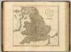
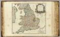
England.
1 : 1600000 Cary, John, ca. 1754-1835
Anglia Regnum
1 : 1700000 Annotatie: Oorspr. verschenen in: Gerardi Mercatoris et I. Hondii Newer Atlas oder Grosses Weltbuch ... - Amsterdam : bey Johan Jansson, 1636 Amstelodami : apud Ioannem Ianssonium

Isles Britanniques
1 Karte : Kupferdruck ; 31 x 41 cm Mentelle; Tardieu; André Mentelle

Le royaume d'Angleterre
1 Karte : Kupferdruck ; 39 x 49 cm Sanson; Fortin chéz Fortin ing.r mécanicien du roy pour les globes rue de la Harpe près la rue du Foin
A new and very accurate map of South Britain or England and Wales
1 Karte : Kupferdruck ; 33 x 40 cm Bowen; Kitchin s.n.
Le royaume d'Angleterre
1 Karte : Kupferdruck ; 38 x 49 cm Sanson chez l'autheur
Anglia, Regnum si quod aliud in toto Oceano ditissimum et florentißimum. [Karte], in: Theatrum orbis terrarum, S. 83.
1 Karte aus Atlas Ortelius, Abraham Vrients, Jan Baptista
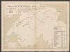
Palaeontological Map
The physical atlas Johnston, Alexander Keith William Blackwood & Sons
Regni Angliæ et Walliæ principatus tabula
1 Karte : Kupferdruck ; 49 x 58 cm Gouwen; Tideman I. Covens et C. Mortier
Anglia regnvm
1 Karte : Kupferdruck ; 37 x 48 cm Janssonius apud Ioannem Ianssonium
Anglia regnvm
1 Karte : Kupferdruck ; 37 x 48 cm Blaeu Joan Blaeu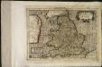
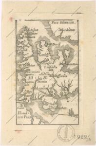
Angliæ regnum
1 Karte : Kupferdruck ; 17 x 24 cm Mercator Joannes van Cloppenburgh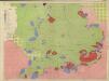
Restricted Flying Areas and Balloon Areas, Air Ministry, GSGS Misc 501
Great Britain War Office General Staff Geographical Section Great Britain Ministry of Defence Survey Production Centre
Grossbritannien im maassstabe von 1:1.500.000 : sudliches Blatt : England (ohne die nordl. Grafschaften) u. Wales
1 : 1500000 Petermann, August Heinrich 1822-1878 Gotha : Justus Perthes
A map of ye south part of Great Britain, called England and Wales, containing all ye cities, market towns, post towns, boroughs: and whatever places have ye election of members of Parliament &c. All the great or post-roads, and principal cross-roads &c. with ye computed miles from town to town
1 : 2200000 by Herman Moll [London], Herman Moll
Le royavme d'Angleterre
1 Karte : Kupferdruck ; 43 x 50 cm, Bildgrösse 43 x 58 cm Nolin; Guérard; Coronelli; Du Tralage; Jean; Mondhare chez Mondhare et Jean rue St. Jean de Beauvais
Le royaume d'Angleterre
1 Karte : Kupferdruck ; 47 x 50 cm Robert de Vaugondy; Santini; Remondini chez Mr. Remondini
Le royaume d'Angleterre
1 Karte : Kupferdruck ; 47 x 50 cm Robert de Vaugondy; Haussard G. et D. Robert de Vaugondy
Le royavme d'Angleterre
1 Karte : Kupferdruck ; 43 x 50 cm, Bildgrösse 43 x 58 cm Nolin; Guérard; Coronelli chez I. B. Nolin sur le quay de l'Horloge du Palais proche la rue de Harlay a l'enseigne de la place des Victoires