Maps of North Rhine-Westphalia

Deutsch - Französischen Kriegsschauplatzes
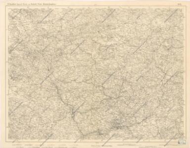
1:500,000 Europe (Air) G.S.G.S. No. 4072, Frankfurt
Sheet NE50-6 from the map series: 1:500,000 Europe (Air) G.S.G.S. No. 4072.
Tractvs Rhenanvs Inferior excusus cura
1 : 810000 Mollova mapová sbírka Weigel, Magdalena Esther Weigel, Johann Christoph - vdova
Operationen der Alliirten und Französischen Armee 1759

[Vestfálsko]
Vestfálsko (Německo)
Die Preussische Provinz Sachsen
1 : 600000 Geographisches Institut (Weimar, Germany)
Rhein Provinz.
1 : 825000 Flemming, Carl

Die preussischen Provinzen Westphalen und Rheinprovinz, das Kurfürstenthum Hessen, das Grossherzogthum Hessen und das Herzogthum Nassau, das Fürstenthum Waldeck, die Landgrafschaft Hessen Homburg und die freie Stadt Frankfurt
1 : 540000 Frankfurt nad Mohanem (Německo) Gräf, A. Luther. Th. Geographisches Institut
Geographisch-statistische Post- und Resekarte zu den besuchtesten Rhein- und Main-Gegenden
1 : 831500 Mohan (Německo) Bauerkeller, Georg J.P. Streng
Charte von den Königlich Preusischen Provinzen Westphalen, Cleve-Berg und Niederrhein dem Kurfürstenthume Hessen, Grosherzogthume Hessen, dem Herzogth. Nassau, Fürstenth. Waldeck und dem Gebiete der freien Stadt Frankfurt
1 : 1080000 Dolní Porýní (Německo) Weiland, Karl Ferdinand im Verlage des Geograph. Instituts
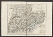
Upper, Lower Rhine circles.
1 : 700000 Cary, John, ca. 1754-1835
Geologische Übersichtskarte der Rheinprovinz und der Provinz Westfalen / bearb. von H. von Dechen
1 : 500000 Annotatie: Oorspr. uitg.: 1866 Heinrich von Dechen Berlin : Schropp
Dioecesis Coloniensis
1 : 650000 Kolín nad Rýnem-oblast (Německo)
Der Chur Rheinsiche- oder Nieder Rheinische Kreis
1 : 620000 Porýní-Falc (Německo) Güssefeld, Franz L. bey den Homännischen Erben
Der Chur Rheinsiche- oder Nieder Rheinische Kreis
1 : 620000 Porýní-Falc (Německo) Güssefeld, Franz L. bey den Homännischen Erben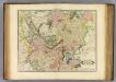
Upper, Lower Rhine.
1 : 720000 Lizars, Daniel
Geologische Übersichtskarte der Rheinprovinz und der Provinz Westfalen / bearb. von H. von Dechen
1 : 500000 Heinrich von Dechen Berlin : Schropp
Berghe Ducatus Marck Comitatus et Coloniensis Dioecesis [Karte], in: Gerardi Mercatoris Atlas, sive, Cosmographicae meditationes de fabrica mundi et fabricati figura, S. 346.
1 Karte aus Atlas Mercator, Gerhard Montanus, Petrus
Berghe Ducatus Marck Comitatus et Coloniensis Dioecesis [Karte], in: Gerardi Mercatoris et I. Hondii Newer Atlas, oder, Grosses Weltbuch, Bd. 1, S. 176.
1 Karte aus Atlas Mercator, Gerhard und Hondius, Jodocus Jansson, Jan
Synopsis circuli Rhenani inferioris sive electorum Rheni
1 : 620000 Porýní-Falc (Německo) Lotter, Tobias Conrad Tobias Conrad Lotter
Synopsis circuli Rhenani inferioris sive electorum Rheni
1 : 620000 Porýní-Falc (Německo) Lotter, Tobias Conrad T. C. Lotter
Synopsis circuli Rhenani inferioris sive electorum Rheni
1 : 620000 Porýní-Falc (Německo) Lotter, Tobias Conrad Tobias Conrad Lotter
SYNOPSIS CIRCULI RHENANI INFERIORIS sive ELECTORUM RHENI
1 : 640000 Porýní-Falc (Německo) Seutter, Matthäus a Matth. Seutter
Synopsis circuli Rhenani inferioris sive electorum Rheni
1 : 620000 Porýní-Falc (Německo) Seutter, Matthäus Matthäus Seutter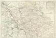
Estats De la Succeßion de Cleves et Iuliers
1 : 860000 Mollova mapová sbírka Sanson, Nicolas Cordier, Robert Sanson, Nicolas
Teutschlands Nieder Rheinischer Creiss mit seinen abgetheilten Provintzen
1 : 2600000 Mollova mapová sbírka Weigel, Christoph Weigel, Christoph I.
La Basse Partie Du Cercle Du Haut Rhein divisé en tous ses Estats et Souverainetés [Karte], in: Atlas nouveau, contenant toutes les parties du monde [...], Bd. 1, S. 285.
1 Karte aus Atlas Sanson, Nicolas Jaillot, Alexis Hubert und Mortier, Pieter