Maps of Bayern
Strassen und Eisenbahnkarte des oesterreichischen Kaiserthumes

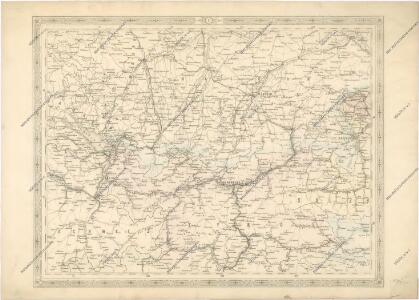
Neueste Karte von Bayern, Tirol mit dem grösten Theil von Schwaben und angränzenden österreichischen Provinzen
1 : 790000 Bavorsko (Německo) Sotzmann, Daniel Friedrich Artaria
Karte von Baiern und Schwaben mit einem grossen Theil von Böhmen, Österreich, Salzburg, Steyermark, Kärnten und Krein
Bavorsko (Německo) Artaria
Königreich Baiern nach der neuesten Begrenzung
1 : 700000 Bavorsko (Německo) Mollo, Tranquillo T. Mollo
Königreich Baiern nach der neuesten Begrenzung
1 : 700000 Bavorsko (Německo) Mollo, Tranquillo T. Mollo
Geologische karte der Republik Österreich und der Nachbargebiete: Die Ostalpen, ihre Ausläufer und Vorlande nebst den angrenzenden Teilen der fränkisch-schwäbischen Alb und des böhmischen Massivs
Vetters, Hermann.
Karte vom Koenigreich Baiern in Kreise eingetheilt
Bavorsko (Německo) Klipstein, A. Walch, Johann bei Joh. Walch
Karte von Deutschland in IV Blättern
1 : 825000 Südwest-Blatt Sotzmann, Daniel Friedrich im Verlage der A. G. Schneider und Weigels
Das Königreich Baiern
1 : 780000 Bavorsko (Německo) Dirwald, Joseph Mannert, Conrad T. Mollo
Charte vom Königreiche Bayern
1 : 1040000 Bavorsko (Německo) Güssefeld, Franz L. Ehnlich, I. F. C. im Verlag des Geograph. Instituts
CHARTE vom KÖNIGREICHE BAYERN
Bavorsko (Německo)
Charte vom Königreiche Bayern
Bavorsko (Německo)
Charte vom Königreiche Bayern
Bavorsko (Německo) Streit, Friedrich Wilhelm
[Atlas zur Geschichte von Bayern] : VII. Das Königreich Bayern nach seinen gegenwärtigen Bestandtheilen mit allen Gebiets-Veränderungen von 1801 bis 1816
K. v. Spruner W. Hase sc. Weimar [Gotha : Perthes]
Das Königreich Baiern nach Mannert und andern vorzüglichen Hülfsmitteln
1 : 690000 Bavorsko (Německo) Dirwald, Joseph Mannert, Conrad T. Mollo
[Atlas zur Geschichte von Bayern] : II. Die Gauen von Bojoaria, Franconia, und eines Theils von Alemannia vom VIIIten bis in’s XIte Jahrhundert
K. v. Spruner [Gotha : Perthes]
[Atlas zur Geschichte von Bayern] : IV. Die Herzogthümer Baiern, Franken, und ein Theil von Alemannien im XII & XIII Jahrhundert nach erblichen Grafschaften & Gebieten getheilt
K. v. Spruner [Gotha : Perthes]
Comitatus Principalis Tirolis in quo Episc. Tridentinus et Brixensis, Comitatus Brigantinus, Feldkirchiae Sonnebergae et Pludentii accurate exhibentur
1 : 570000 Mollova mapová sbírka Homann, Johann Baptist Homann, Johann Baptista
Comitatus Principalis Tirolis in quo Episc. Tridentinus et Brixensis, Comitatus Brigantinus, Feldkirchiae Sonnebergae et Pludentii accurate exhibentur
1 : 570000 Mollova mapová sbírka Homann, Johann Baptist Homann, Johann Baptista
Principali Dignitate Gaudens Comitat Tirolis Episcopat. Tridentinum et Brixiensem ut et Comitut. Brigantinum Feldkirch Sonneberg et Pludeninum continens quo ad omnes Urbes oppida arces coenobia pagos exactissime designata cura et manu
1 : 575000 Mollova mapová sbírka Seutter, Matthäus Seutter, Matthäus
Comitatus principalis Tirolis in quo episc. Tridentinus et Brixensis, comitatus Brigantinus, Feldkirchiae Sonnebergae et Pludentii accurate exhibentur
1 : 570000 Itálie severní Homann, Johann Baptist Ioh. Baptist Homann
[COMITATUS PRINCIPALIS TIROLIS in quo EPISC. TRIDENTIN[US] ET BRIXENSIS, Comitatus Brigantinus, Feldkirchiae Sonnebergae et Pludentii accurate exhibentur]
1 : 600000 Itálie severní Homann, Johann Baptist Ioh. Baptist Homann
Comitatus principalis Tirolis in quo episc. Tridentin[us] et Brixensis, comitatus Brigantinus, Feldkirchiae Sonnebergae et Pludentii accurate exhibentur
1 : 570000 Bludenz-oblast (Rakousko) Homann, Johann Baptist Ioh. Baptista Homanno
Comitatus principalis Tirolis in quo episc. Tridentin[us] et Brixensis, comitatus Brigantinus, Feldkirchiae Sonnebergae et Pludentii accurate exhibentur
1 : 570000 Bludenz-oblast (Rakousko) Homann, Johann Baptist Ioh. Baptista Homanno
Comitatus principalis Tirolis in quo episc. Tridentin[us] et Brixensis, comitatus Brigantinus, Feldkirchiae Sonnebergae et Pludentii accurate exhibentur
1 : 570000 Bludenz-oblast (Rakousko) Homann, Johann Baptist Ioh. Baptista Homanno
Comitatus principalis Tirolis in quo episc. Tridentinus et Brixensis, comitatus Brigantinus, Feldkirchiae Sonnebergae et Pludentii accurate exhibentur
1 : 570000 Itálie severní Homann, Johann Baptist Ioh. Baptist Homann
La Souabe
1 Karte : Kupferdruck ; 39 x 40 cm Sanson chez l'autheur
Die Fürstliche Graffschaft Tyrol : mitt Inliegenden Beyden Fürstlichen Stiftern Trient und Brixen als auch zugehoerigen Graff und Herschafften Bregenz, Feldkirch, Pludenz, Sonnenberg, Hoheneck und den Angraentzenden Teütschen und Welschen Laendern und ...
Stridbeck, Johann
Rhetiae alpestris descriptio, in qua hodie Tirolis Comitatvs
1 : 100000 Mollova mapová sbírka Ortelius, Abraham