Maps of Brescia

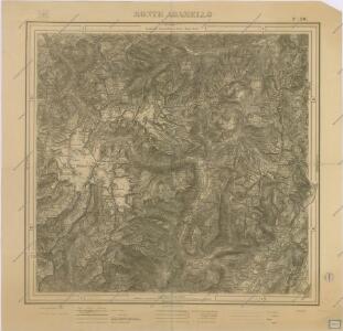
Monte Adamello

Tione und M.Adamello.
from Spezialkarte der osterreichisch-ungarischen Monarchie.
Karte der Adamello- und Presanella-Gruppe
1 : 50000 Alpy italské (pohoří) Deutscher u. Oesterreichischer Alpen Verein
Bormio und Passo Del Tonale.
from Spezialkarte der osterreichisch-ungarischen Monarchie.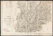
Carte du Tyrol
1 : 150000 Südwest-Blatt Anich, Peter par le Dépôt Général de la Guerre
Carta geologica delle provinicie Lombarde
1 : 172800 Ostblatt Curioni, G. Hoepli
Carte particulière du Bressan faisant partie des états de la république de Venise : levée par ordre exprès à l'usage des armées en Italie &c
1 : 220000 par le Sr Sanson, Geograph. du Roy A Amsterdam : chez Pierre Mortier
Carte Particuliere Du Bressan Faisant Partie des Etats dela Republique De Venise Leveé Par Ordre Exprès á L'Usage des Armées En Italie &c. [Karte], in: Atlas nouveau, contenant toutes les parties du monde [...], Bd. 2, S. 166.
1 Karte aus Atlas Sanson, Nicolas Jaillot, Alexis Hubert und Mortier, Pieter
Distanzenkarte von der Schweiz
1 : 200000 1 Karte in 8 Teilen nach den besten Hülfsquellen bearb. von R. Huber Wagner, Bern
Wandkarte der Schweiz
1 : 200000 1 Karte auf 8 Blättern J.M. Ziegler Wurster, Winterthur
TERRITORIO | di | BRESCIA | et di | CREMA
Apud Guiljelmum | et Joannem Blaeu
Trient
1 : 200000 1 Karte entworfen und bearbeitet von Woerl ; in Stein gestochen unter seiner Leitung ; Lithographie von B. Herder Herder, Freiburg im Breisgau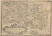
Bresciano Brixiani Agri Typus. Brixia, Cygnea supposita in specula. [Karte], in: Theatrum orbis terrarum, S. 299.
1 Karte aus Atlas Ortelius, Abraham Vrients, Jan Baptista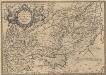
Veronae Urbis Territorium [Karte], in: Theatrum orbis terrarum, S. 290.
1 Karte aus Atlas Ortelius, Abraham Vrients, Jan Baptista
Touristen-Karte der ostrhätischen Kurorte
1 : 200000 1 Karte Topogr. Anstalt v. Wurster, Randegger & Co. In Commission bei Wurster, Randegger & Co., Winterthur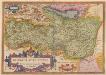
Bresciano Brixiani Agri Typus. Brixia, Cygnea supposita in specula. [Karte], in: Theatrum orbis terrarum, S. 204.
1 Karte aus Atlas Ortelius, Abraham
Territorio di Brescia et di Crema [Karte], in: Novus Atlas, das ist, Weltbeschreibung, Bd. 3, S. 112.
1 Karte aus Atlas Blaeu, Joan Blaeu, Willem Janszoon
Territorio di Brescia et di Crema [Karte], in: Le théâtre du monde, ou, Nouvel atlas contenant les chartes et descriptions de tous les païs de la terre, Bd. 3, S. 108.
1 Karte aus Atlas Blaeu, Willem Janszoon und Blaeu, Joan Blaeu, Willem Janszoon
Territorio di Brecia et di Crema [Karte], in: Theatrum orbis terrarum, sive, Atlas novus, Bd. 3, S. 94.
1 Karte aus Atlas Blaeu, Joan Blaeu, Willem Janszoon
Carte de la Suisse avec les plans des cheflieux des 22 cantons
1 : 200000 1 Karte auf 8 Bl. dessinée et publié par Henri Keller ; Lithogr. von J. Schweizer = Charte der Schweiz mit den Grundrissen der Hauptorte der 22 Cantone Keller, Zürich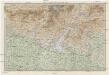
Karte der Lombardischen und Süd-Tiroler-Alpen
1 : 250000 Ravenstein, Ludwig Ludwig Ravenstein
Tyrolis pars meridionalis
1 : 218000 Trident (Itálie : provincie) Spergs, Ioseph de Homannianis Hered.
Karte der West-Tiroler und Engadiner Alpen
1 : 250000 Ravenstein, Ludwig Geographische Anstalt von L. Ravenstein
Territorio di Brescia et di Crema [Karte], in: Novus atlas absolutissimus, Bd. 5, S. 29.
1 Karte aus Atlas Janssonius Offizin

Das Hertzogthum Mantova und Mirandola Sampt Angraentzenden Venedischen Laendern
1 : 500000 Mollova mapová sbírka Bodenehr, Gabriel Bodenehr, Gabriel
Territorio Di Brescia Et Di Crema [Karte], in: Gerardi Mercatoris et I. Hondii Newer Atlas, oder, Grosses Weltbuch, Bd. 2, S. 243.
1 Karte aus Atlas Mercator, Gerhard und Hondius, Jodocus Jansson, Jan
[Keller's Reisekarte der Schweiz]
1 : 500000 1 Karte auf 6 Bl. gezeichnet v. H. Keller ; gest. v. J.J. Scheurmann [Keller], Zürich
Territorio Di Trento [Karte], in: Novus Atlas, das ist, Weltbeschreibung, Bd. 3, S. 154.
1 Karte aus Atlas Blaeu, Joan Blaeu, Willem Janszoon