Maps of Slovakia

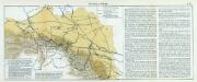
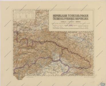
Republique Tchecoslovaque

Sbírka map a diagramů použitých na mírových konferencích v Paříži v letech 1919 - 1920

Politické rozdělení Československé republiky
Vojenský zeměpisný ústav
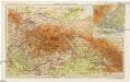
Galizien und Nordost-Ungarn
1 : 600000 Halič (Polsko a Ukrajina) Herrich, Alwin Carl Flemming
Galizien und Nordost-Ungarn
1 : 600000 Evropa východní Herrich, Alwin Carl Flemming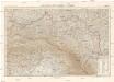
Galizien und Nordostungarn
1 : 600000 Halič (Polsko a Ukrajina) Herrich, Alwin Carl Flemming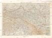
Galizien und Nordost-Ungarn
1 : 600000 Evropa východní Herrich, Alwin Carl Flemming
Lubomeriae et Galliciae regni tabula geographica
1 : 1088000 Halič (Polsko a Ukrajina) Güssefeld, Franz L. impensis Homannianorum Haeredum
Náčrt Československé republiky

General- Post- und Strassen Karte des Königreich Galizien
1 : 871000 Halič (Polsko a Ukrajina) Schulz, R. A. Artaria
Mapa powierzchni szczytowej Karpat i ich przedmurza = Carte de la surface des faîtes des Karpates et de leur avant pays
1 : 1000000 Teisseyre, Henryk Lwow ; Warszawa : Ksiaznica-Atlas
Das Königreich Galizien und das Herzogthum Bukowina
1 : 2000000 Halič (Polsko a Ukrajina) Kocen, Blaž Ed. Hölzel
Das Koenigreich Galizien
1 : 1090000 Halič (Polsko a Ukrajina) Weiland, Karl Ferdinand im Verlage des Geograph. Instituts
Das Koenigreich Galizien
1 : 1090000 Halič (Polsko a Ukrajina) Weiland, Karl Ferdinand im Verlage des Geograph. Instituts
Das Koenigreich Galizien
1 : 1090000 Halič (Polsko a Ukrajina) Weiland, Karl Ferdinand im Verlage des Geograph. Instituts
Das Koenigreich Galizien
1 : 1100000 Halič (Polsko a Ukrajina) Weiland, Karl Ferdinand im Verlage des Geograph. Instituts
Das Koenigreich Galizien
1 : 1090000 Halič (Polsko a Ukrajina) Weiland, Karl Ferdinand im Verlage des Geograph. Instituts
Das Koenigreich Galizien
1 : 1090000 Halič (Polsko a Ukrajina) Weiland, Karl Ferdinand Zap, Karel Vladislav im Verlage des Geograph. Instituts
Das Königreich Galizien
1 : 1630000 Halič (Polsko a Ukrajina) Weiland, Karl Ferdinand im Verlage des Geograph. Instituts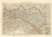
Galizien und Nordost - Ungarn
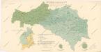
Mapa průměrných ročních srážek republiky Československé za období 1876 - 1902

Carte nouvelle des royaumes de Galizie et Lodomerie avec le district de Bukowine
1 : 2000000 A Augsbourg : ches Tobie Conrad Lotter
[Österreich-Ungarn, Blatt 2]
Adolf Stieler's Handatlas über alle Theile der Erde und über das Weltgebäude Stieler, Adolf Justus Perthes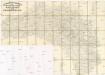
Strassen-Karte des Koenigreiches Galizien und Lodomerien
1 : 430000 Halič (Polsko a Ukrajina)
Strassen-Karte des Koenigreiches Galizien und Lodomerien
1 : 430000 Halič (Polsko a Ukrajina)
Galizien, Karpathen, Bukowina nebst anschließendem Ungarn, Russland u. s. w.
Ravenstein, Hans
Přehledná letecká mapa republiky Československé
Reichsratwahlkarte
Slovensko a Zakarpatská Ukrajina
1 : 1250000 Bratislava (Slovensko) Kuchař, Karel V. Neubert a synové