Maps of Pardubický
Mapa království Českého 8.
[Nová Mapa království Českého]
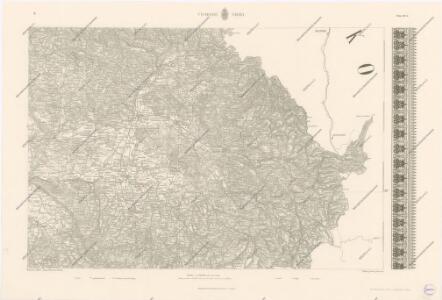
1 : 200000 Čechy východní (Česko) Kotyška, Václav Hanf, Norbert Bursík & Kohout
General Karte der Markgrafschaft Mähren und des Herzogthums Schlesien
Prozkoumání Čech, sekce VI.
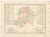
R. 1889 Českým sněmem navržený obvod obchodní komory pro východní Čechy
Čechy východní (Česko) Milbauer, Emanuel Vlastimil
Prozkoumání Čech, sekce VI.
Prozkoumání Čech, sekce VI.

Indikační skica mapy stabilního katastru pro obec Hoděšovice I.-V.
1 : 2880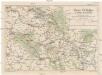
Hory Orlické a kraje sousední
Orlické hory-oblast (Česko a Polsko) Kašpar, Karel Slavoj Hofmeister, Stanislav Odbor Klubu československých turistů
Charte vom Königgrätzer Kreise ...

Lage der Hochweiden in den Ostsudeten
1 : 75000 Sudety (Česko)
Special-Karte des Chrudimer Kreis, resp. politischen Verwaltungsbezirkes in Böhmen
1 : 213000 Chrudim-oblast (Česko) Schmidt, Eduard Wend. Morauer
Special-Karte des Chrudimer Kreis - resp. politischen Verwaltungsbezirkes in Böhmen
1 : 213000 Chrudim-oblast (Česko) Schmidt, Eduard Wend. Morauer
Special-Karte des Chrudimer Kreis, resp. politischen Verwaltungsbezirkes in Böhmen
1 : 213000 Chrudim-oblast (Česko) Schmidt, Eduard Wend. Morauer
Strassen Charte des Chrudimer Kreises
1 : 48000 Chrudim (Česko : oblast) Werner, K.
Königgrätz 104, uit: Special-Karte von Mittel-Europa / nach amtlichen Quellen bearbeitet von W. Liebenow
1 : 300000 titelvariant: W. Liebenow's Mittel-Europa; Annotatie: Titel boven de bladen: W. Liebenow's Mittel-Europa Johannes Wilhelm Liebenow 1822-1897 Frankfurt a. M. : Ludwig Ravenstein
Charte vom Chrudimer Kreise des Königreiches Böheim
General-Karte der Markgrafschaft Maehrem...

Soustavná elektrisace území Východočeského elektrárenského svazu, spol. s r. o. (VČES) v Pardubicích
1 : 200000 Čechy východní (Česko) Wagner, Jan Eduard Štumper, Karel Vojenský zeměpisný ústav
Special-Karte des Königgrätzer Kreis, resp. politischen Verwaltungsbezirkes in Boehmen
1 : 231000 Hradec Králové-oblast (Česko) Schmidt, Eduard Steyrer, Fr. C. Wend. Morauer
Spezial-Karte des Königgrätzer Kreis...

Special-Karte des Königgrätzer Kreis - resp. politischen Verwaltungsbezirkes in Boehmen
1 : 230000 Hradec Králové-oblast (Česko) Schmidt, Eduard Wend. Morauer
Special-Karte des Königgrätzer Kreis - resp. politischen Verwaltungsbezirkes in Boehmen
1 : 231000 Hradec Králové-oblast (Česko) Schmidt, Eduard Wend. Morauer
Special-Karte des Königgrätzer Kreis - resp. politischen Verwaltungsbezirkes in Boehmen
1 : 230000 Hradec Králové-oblast (Česko) Schmidt, Eduard Wend. Morauer
Charte des Chrudimer Kreises im Koenigreiche Boehmen
Chrudim-oblast (Česko) Hollmann, Victor Josef Pluth, Franz Ad. Christoph & W. Kuhé
okres Chrudim
1 : 200000
Panorama se Zvičiny 671 m. u Dvora Králové n. L
Bílá Třemešná (Česko) Pacelt, Čeněk Klub českých turistů
Chrudimer Kreis

Chrudimer Kreis

Charte vom Chrudimer Kreise des Königreiches Böheim
1 : 260000 Chrudim-oblast (Česko) Kreibich, František Jakub Jindřich Pluth, Franz C. W. Enders
Charte vom Chrudimer Kreise des Königreiches Böheim
1 : 236000 Chrudim-oblast (Česko) Kreibich, František Jakub Jindřich Enders, C. W. C.W. Enders
Charte vom Chrudimer Kreise des Königreiches Böheim
1 : 236000 Chrudim-oblast (Česko) Kreibich, František Jakub Jindřich Enders, C. W. C.W. Enders
Charte vom Chrudimer Kreise des Königreiches Böheim
1 : 236000 Chrudim-oblast (Česko) Kreibich, František Jakub Jindřich Enders, C. W. C.W. Enders
Charte vom Chrudimer Kreise des Königreiches Böheim
1 : 236000 Chrudim-oblast (Česko) Kreibich, František Jakub Jindřich Enders, C. W. C.W. Enders