Maps of okres Mělník
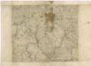
Mappa geographica regni Bohemiae in duodecim circuloc divisae ... Sectio. VIII.
Mappa geographica regni Bohemiae in duodecim circulos divisae ...

Monumenta Cartographica Bohemiae II.: Müllerova mapa
Müllerova mapa Čech
1 : 132000
Bunzlauer Kreis
Mladá Boleslav-oblast (Česko) Koch
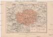
České středohoří
1 : 360000 České středohoří (Česko : oblast) Tocl, Karel Ed. Grégr
Übersichtsplan der projectirten Eisenbahn-Trace von Zittau über Böhmisch Leipa bis zum Anschlusse an die k.k. Staatseisenbahn bei Unter Beřkowitz
1 : 47000 Dolní Beřkovice (Česko)
Sect. 98 - Roudnice

Übersichtsplan der projectirten Eisenbahn Traçe von Zittau über Böhmisch Leipa bis zum Anschlusse an die k.k. Staats-Eisenbahn bei Unter Beřkowitz
1 : 220000 Dolní Beřkovice (Česko) Kozlik, Ignaz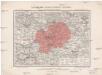
Generální mapa okresního hejtmanství Mělnického
1 : 220000 Mělník-oblast (Česko) Wagner, Jan Eduard F. Kytka
Melnik.
from Spezialkarte der osterreichisch-ungarischen Monarchie.
Vilímkovy podrobné mapy politických okresů

Theil von Böhmen

Übungs-Rayon
1 : 144000 Hradec Králové (Česko : oblast)
168 Jung Bunzlau, uit: Topographische Special-Karte von Deutschland (von Central-Europa) / begründet von D.G. Reymann ; [entworfen und gezeichn. von Heinrich Berghaus... [et al.]]
1 : 200000 Annotatie: Lit.: Daniel Gottlob Reymann und die "Topographische Special-Karte von Deutschland" / von Wolfgang Scharfe, in: Kartographische Nachrichten, 39 (1989), Heft I, p. 1-10; Handgeschreven titel: Reymann's Deutschland : 24 Sectionen: Jena, Penig, Dresden, Zittau, Hirschberg, Breslau, Brieg, Andernach, Coblenz, Giessen, Fulda, Schleusingen, Plauen, Zwickau, Teplitz, Jung Bunzlau, Hohenelbe, Glatz, Neisse, Simmern, Prag, Luxemburg, Birkenfeld; Aanwezig: 23 bladen Reymann, Daniel Gottlob; Berghaus, Heinrich [Berlin : 2. Departement des Kriegsministeriums, Bureau für Plan- und Kartenzeichnung]
Podrobná mapa Království českého
1 : 100000 Mělník (Česko : oblast) Srp, Jan Jaroslav Bursík
Podrobná mapa Království českého, Markrabství moravského a Vévodství slezského
1 : 100000 Moravské markrabství Srp, Jan Jos. R. Vilímek
Bhm. Leida und Dauba.
from Spezialkarte der osterreichisch-ungarischen Monarchie.
Verbindungs-Dreiecke der Grundlinie zwischen dem Lorenz- und Georgeberge mit der trigonometrischen Vermessung der Gegend um Neuschloss
1 : 230000 Středočeský kraj (Česko : 2000-)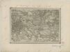
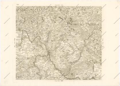
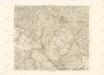
II. vojenské mapování 8
1 : 144000
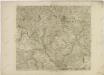
II. vojenské mapování 8
1 : 144000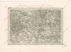
Special - Karte des Koenigreiches Boehmen

Kartenskizze zur Entwicklung des Moldau-Elbetales
1 : 100000 Labe (Česko a Německo : řeka : střední tok)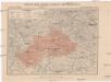
Generální mapa okresního hejtmanství Mnich. Hradištského
1 : 220000 Mnichovo Hradiště-oblast (Česko) Wagner, Jan Eduard F. Kytka
Prag
1 : 200000 Praha-oblast (Česko) Fils Brose, Heinrich
Mapa okresního hejtmanství Mlado-boleslavského
1 : 100000 Mladá Boleslav (Česko : okres : 1960-) Erben, Josef nákladem Karla Janského
Gegend bei Jungbunzlau, Lissa und Brandeis
1 : 250000 Brandýs nad Labem-Stará Boleslav-oblast (Česko)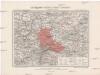
Generální mapa okresního hejtmanství Karlínského
1 : 220000 Karlín (Praha, Česko) Wagner, Jan Eduard Mareš, František F. Kytka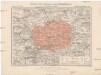
Generální mapa okresního hejtmanství Karlínského
1 : 220000 Karlín (Praha, Česko) Wagner, Jan Eduard F. Kytka