Maps of Southwest

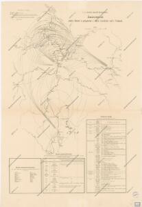
Znázornění hlásné služby a prognosní o stavu vysokých vod v Čechách
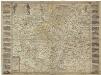
Bohemia in suas partes geograph. distinc
Česko Sandrart, Jakob von Jacob Sandrart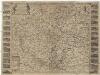
Bohemia in suas partes geograph. distinc
Česko Sandrart, Jakob von Jacob Sandrart
Bohemia in suas partes geograph. distinc
Česko Sandrart, Jakob von Jacob Sandrart
Theatre de la guerre en Boheme avec les principaux postes de ce roayume
1 : 890000 Česko Le Rouge, Georges-Louis Sr. le Rouge
Neueste general Post & Strassen Karte des Königreichs Boehmen
1 : 590000 Česko Schönfelder von Feuersfeld, Franz Berra, Marco Marco Berra
Neueste general Post & Strassen Karte des Königreichs Boehmen
1 : 575000 Česko Schönfelder z Feuersfeldu, František Berra, Marco Marco Berra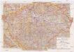
Mittelbach's neueste Specialkarte von Böhmen zum Hand- und Kontorgebrauch
1 : 300000 Česko Mittelbach Mittelbach's Verlag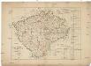
Das Kronland Böhmen
Čechy (Česko) Joseph Bermann
Mapa Království českého v 10 listech a v měřítku 1:200,000
1 : 200000 Čechy (Česko)
Land Böhmen
1 : 1000000 Most (Česko : oblast) Paul Sollors' Nachf.
Entwurf einer Uibersicht der neuen Entheilung der Kronlandes Böhmen
Čechy (Česko) Stifter, Johann Steyrer, Fr. C. Fr.C. Steyrer
Geognostische Uibersichts-Karte der Kohlenführenden Formationen von Böhmen
Čechy (Česko) Hennig Verlag der J.G. Calve'schen Buchhandlung
Geognostische Uibersichts-Karte von Böhmen
Čechy (Česko) Hennig Verlag der J.G. Calve'schen Buchhandlung
Národnostní mapa Království českého
Čechy (Česko) Waraus, E. Wagner, Jan Eduard F. Kytka
Mapa Království českého pro cestující, turisty, cyklisty a. t. d
1 : 500000 Praha-oblast (Česko) Wagner, Jan Eduard Mareš, František Alois Hynek
Čechy
1 : 1000000 Praha (Česko) Semík, Matěj nákladem Ústředního nakladatelství a knihkupectví učitelstva českoslovanského
Generální mappa [sic] Království českého
1 : 432000 Česko Kořistka, Karel František Edvard sklad Eduarda Hölzela
Mapa jednot České obce sokolské v září 1889
Čechy (Česko) Podlipný
Mapa jednot České obce sokolské v září 1889
Čechy (Česko) Podlipný
Čechy
Čechy (Česko)
Bouřkové stanice v Čechách v Čechách 1905-1915
1 : 750000 Česko
Králowství České
1 : 1350000 Čechy (Česko) sklad Karla André
Králowství České
Česko Schlieben Ausfeld, Johann Carl sklad Karla André
Oro-hydrografische Karte von Böhmen
Čechy (Česko) Jelínek, Karel Langweil, Antonín K. André
Oro-hydrografische Karte von Böhmen
Čechy (Česko) Jelínek, Karel Langweil, Antonín
[Orografická mapa Čech]
Čechy (Česko) bei Eduard Hölzel
Strassen- Uibersichts- und Militair-Routen-Karte des Königreichs Böhmen
1 : 580000 Česko Windisch-Graetz, Alfred Kandidus Marco Berra
Tabvla geographica inclyti Boemiae Regni
1 : 900000 Česko