Maps of Plzeňský
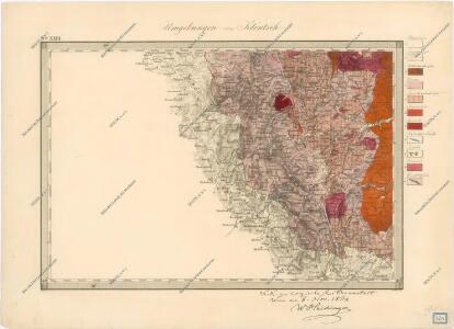
Umgebungen von Klentsch

Sacri imperii Romani circuli et electoratus Bavariæ, 2
1 Karte : mehrfarbig ; R. et J. Ottens
An den Pilsner und Klattauer und Prachiner Kr [sic] angrezende Baiern
Bavorsko (Německo) Kreibich, František Jakub Jindřich
Sacri Imperii Romani Circuli et Electoratus Bavariae cum Finitimis Geographica Descriptio. Cum Privilegio D.D. Ordinum Generalium ut et Hollandiae West Frisiaequae]
1 : 270000 Mollova mapová sbírka Valck, Leonardus
Pilsner Kreis
Plzeň (Česko : oblast) Berndt, Johann Christoph Anton Elsenwanger
Pilsner Kreis
Plzeň-oblast (Česko) Berndt, Johann Christoph Anton Elsenwanger
Pilsner Kreis
Plzeň-oblast (Česko) Berndt, Johann Christoph Anton Elsenwanger
Provincia Pilsnensis
Plzeň-oblast (Česko) Bernardi, Augustin Augustin Bernardi
Provincia Pilsnensis
Plzeň-oblast (Česko) Winkler, Johann Christoph
Provincia Pilsnensis
Plzeňský kraj (Česko) Müller, Johann Christoph
Provincia Pilsnensis
Plzeň-oblast (Česko) Müller, Johann Christoph JC. Winkler
Západočeské lázně

A. Pilsner und B. Klattauer Kreis

A. Pilsner und B. Klattauer Kreis...

Special-Karte des Egerer Kreis, resp. politischen Verwaltungsbezirkes Königreiche Böhmen
1 : 224000 Cheb-oblast (Česko) Schmidt, Eduard Wendelin Morauer
Special-Karte des Egerer Kreis, resp. politischen Verwaltungsbezirkes Königreiche Böhmen
1 : 224000 Cheb-oblast (Česko) Schmidt, Eduard Steyrer, Fr. C. Wendelin Morauer
Special-Karte des Egerer Kreis, resp. politischen Verwaltungsbezirkes Königreiche Böhmen
1 : 224000 Cheb-oblast (Česko) Schmidt, Eduard Wendelin Morauer
Special-Karte des Pilsner Kreis - resp. politischen Verwaltungsbezirkes im Boehmen
1 : 229000 Plzeňský kraj (Česko) Schmidt, Eduard Flemming, C.
Special-Karte des Pilsner Kreis, resp. politischen Verwaltungsbezirkes in Boehmen
1 : 229000 Plzeň-oblast (Česko) Schmidt, Eduard Wend. Morauer
Special-Karte des Pilsner Kreis, resp. politischen Verwaltungsbezirkes in Boehmen
1 : 229000 Plzeň-oblast (Česko) Schmidt, Eduard Wend. Morauer
A. Pilsner und B. Klattauer Kreis
Klatovy-oblast (Česko) A. Elsenwanger
A. Pilsner und B. Klattauer Kreis
Bavorsko (Německo) Elsenwanger, Antonín A. Elsenwanger
A. Pilsner und B. Klattauer Kreis
Bavorsko (Německo) Elsenwanger, Antonín A. Elsenwanger
A. Pilsner und B. Klattauer Kreis
Bavorsko (Německo) Elsenwanger, Antonín A. Elsenwanger
Sacri Romani imperii circuli et electoratus Bavariae tabula, 2
4 Blätter : s.n.
Circulus Pilsnensis
Plzeň-oblast (Česko) Glocksperger, Johannes
Charte ehermaliger Burgen & Vesten im Pilsner & Klattauer Kreise Böhmens
1 : 530000 Klatovy-oblast (Česko)
Turistická mapa značených cest v západních Čechách
Nová mapa Království Českého: Jihozápadní Čechy