Maps of Praha

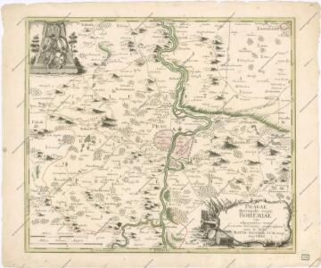
Pragae Metropolis regni Bohemiae
Plan der Battaille welche d. 6. Maj zwischen der kayserlich-königlich-ungarischen und königlich preussischen Armée bey Prag geliefert worden, 1757
Praha (Česko)
Nejnovější plán král. hlav. města Prahy a sousedních předměstí
1 : 12000
Plan der Battaille welche d. 6. Maj zwischen den Kayserl. Königl. Ungarische[n] u. Königlich Preusische[n] Armee bey Prag geliefert worden. 1757
1 : 90000
Bez titulu: Čechy – kolekce vedut
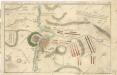
Accurate Vorstellung der zwischen den Oesterreichischen und Preussischen Armeen ... Bataille bey Prag...

Podrobné mapy zemí Koruny české v měřítku 1:75.000 a mapa vzdáleností všech míst při silnici ležících
1 : 75000 Brandýs nad Labem-Stará Boleslav (Česko : oblast) Bělohlav, Josef F. Topič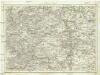
Umgebung von Prag
Praha-oblast (Česko) Biller, Bernhardt Marco Berra
Eisenbahn Karte Wien-Dresden, Ollmütz-Trübau
1 : 72000 Blatt 13 Minarzik, Anselm J. Rauh
Podrobné mapy zemí koruny české v měřítku 1:75 000 a průvodce statisticko-historický po všech místech na těchto mapách uvedených. - Praha-Brandýs n. L. List 55
1 : 75000
Výškopisný plán hlavního města Prahy s okolím
1 : 20000 Praha (Česko) obec Pražská
[Umgebungen der königl. Hauptstadt Prag]
1 : 45000 Praha-oblast (Česko) Basdar
Belagerung der königlicher Haupt-Stadt Prag...

Podrobné mapy zemí Koruny české v měřítku 1:75.000 - Smečno - Kladno - Unhošť. Průvodce statisticko-historický po všech místech na těchto mapách uvedených a rejstřík věcný názvů hor, potoků, řek, rybníků atd. a mapa vzdáleností všech míst při silnici ležících Sešit 4. List 41,
1 : 75000
Podrobné mapy zemí Koruny české v měřítku 1:75.000 - Praha - Brandýs n. L. Průvodce statisticko-historický po všech místech na těchto mapách uvedených a rejstřík věcný názvů hor, potoků, řek, rybníků atd. a mapa vzdáleností všech míst při silnici ležících Sešit 1. List 55,
1 : 75000
Belagerung der Königl. Haupt-Stadt Prag
1 : 57000 Berounka (Česko) Werner, Bedřich Bernard Strahowsky, B.
Praha a okolí
Praha (Česko : oblast) Kuchař, Karel
Situations-Plan der Fürst zu Fürstenberg'schen Herrschaft Pürglitz, Kruschowitz, dann des Gutes Nischburg, Wschetatt und Wolleschna etc
1 : 84000 Křivoklát-oblast (Česko) Bohutinský, Friedrich Fürstenberg, Karl Egon
Praha - městská hromadná doprava
1 : 40000
Regulační plán Velké Prahy s okolím
1 : 50000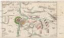
Accurate Vorstellung der zwischen den oesterreichischen und preussischen Armeen geschehenen Bataille bey Prag, den 6. May 1757
Praha (Česko)
Městské podniky Pražské


[Praha a okolí]
Praha-oblast (Česko)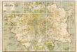
Orientační plán hlavního města Prahy
1 : 14000
Plán velké Prahy
1 : 19000 Praha (Česko) Grgurič, Václav Sádlo, Jiří A. Storch syn
Zu Bildner des Heeres Beilage 9
1 : 63000 Praha-oblast (Česko) K.k. Schulbücher-Verschleiss-Administration