Maps of South America
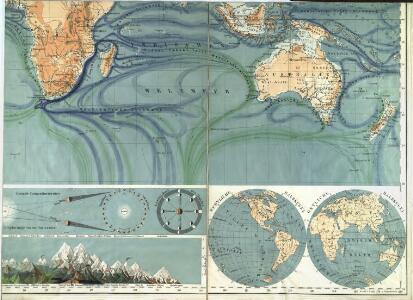
Physikalische Wandkarte der Erde in Merkartor's Projection

America Meridionalis
1 : 27500000 L'Isle, Guillaume de, 1675-1726 C. Weigelii Sen. Hæredum
Africa. Australia and New Zealand.
1 : 31000000 Schonberg & Co.
City of Sydney, Sections 56,57 & 58, 1888
New South Wales. Department of Lands
Světová těžba nerostných surovin
Vents (Amerique)
1 : 50000000 Vincent
Australien und der Hinterindische Archipel
Austrálie Biller, Franz
Atlas für Handel und Industrie: Für Kaufleute, Fabrikante u. Gewerbetreibende, Handlungs- u. Gewerbe-Schulen

America meridionalis
1 : 19000000 Jižní Amerika Delisle, Guillaume Lotter, Gustav Konrad T. C. Lotter
Australasia.
1 : 37000000 Arrowsmith, Aaron; Lewis, Samuel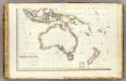
Oceanie 3.
1 : 15500000 Brue, Adrien Hubert, 1786-1832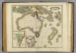
Australia &c.
1 : 19000000 Lizars, Daniel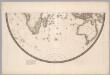
Southern Half, Eastern Hemisphere.
1 : 22500000 Brue, Adrien Hubert, 1786-1832
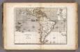
South America.
1 : 25344000 Carey, Mathew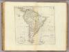
Map Of South America.
1 : 25344000 Carey, Mathew
South America.
1 : 26000000 Carey, Mathew
Map Of South America.
1 : 25344000 Carey, Mathew
South America and the Adjacent Islands.
1 : 3450000 Morse, Jedidiah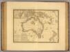
Australie.
1 : 16000000 Picquet, C.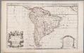
South America, divided into its principall parts viz. the Firm-Land, Peru, Chili, Brasil, Paraguay the Magellanick Land and Islands, in which are distinguished the severall countries as they are at present possessed by the Spanish, English, Portugals, French, and Dutch, etc. / described by Sanson ; corr. and amended by William Berry
1 : 16000000 titelvariant: South America, divided into its principall parts, where are distinguished the severall states which belong to the Spanish, English, Portugals, and French; Annotatie: Titel in cartouche linksonder: South America, divided into its principall parts, where are distinguished the severall states which belong to the Spanish, English, Portugals, and French; Met opdracht aan Charles II Sanson, Nicolas; Berry, William London : William Berry
South America
Este mapa, sin fecha y sin autor conocido, probablemente sea de mediados del siglo XVIII. La representación de Islas Malvinas a partir del Estrecho de Falkland, como era común en la primera mitad del siglo XVIII, es un indicio en ese sentido. En enero de 1690 el inglés John Strong navegó entre las dos islas principales y llamó al paso "Falkland Channel" en honor a su mecenas el Vizconde de Falkland que como había financiado la expedición. La cartografía británica adoptaría en el siglo XVIII el nombre del canal, para designar a todo el grupo de islas, que reclamaría para Inglaterra, en contra de España. En 1740 hubo un enfrentamiento naval entre las fuerzas británicas y españolas por las islas, sin un claro vencedor. Las tensiones entre los dos imperios continuaría a lo largo del siglo XVIII.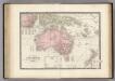
Australie, Nouvelle-Zelande.
1 : 15000000 Levasseur, E.
South America.
1 : 48000000 Seaman, James V.
Carte de l'Empire Espagnol dans les deux Ameriques.
1 : 24000000 Martin de Moussy, V. (Victor), 1810-1869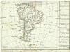
[Jižní Amerika]
1 : 50850000 Jižní Amerika
South America.
1 : 32000000 Smiley, Thomas T.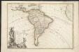
L'Amerique meridionale divisée en ses principaux etats
1 : 1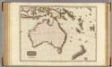
Australasia.
1 : 12000000 Pinkerton, John, 1758-1826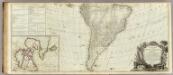
A new map of the whole continent of America (southern section)
1 : 12800000 Sayer, Robert