Maps of Frilford
Berkshire IX.NE - OS Six-Inch Map
1 : 10560 Topographic maps Ordnance Survey Ordnance Survey
Berkshire IX.NE - OS Six-Inch Map
1 : 10560 Topographic maps Ordnance Survey Ordnance Survey
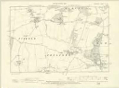
Berkshire IX.3 (includes: Appleton with Eaton; Frilford; Fyfield; Kingston Bagpuize; Tubney) - 25 Inch Map
1 : 2500 Topographic maps Ordnance Survey Ordnance Survey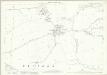
Berkshire IX.3 (includes: Appleton with Eaton; Frilford; Fyfield; Kingston Bagpuize; Tubney) - 25 Inch Map
1 : 2500 Topographic maps Ordnance Survey Ordnance Survey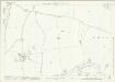
Berkshire IX.7 (includes: Frilford; Fyfield; Garford; Kingston Bagpuize; Tubney) - 25 Inch Map
1 : 2500 Topographic maps Ordnance Survey Ordnance Survey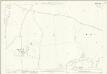
Berkshire IX.7 (includes: Frilford; Fyfield; Garford; Kingston Bagpuize; Tubney) - 25 Inch Map
1 : 2500 Topographic maps Ordnance Survey Ordnance Survey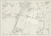
Berkshire IX.4 (includes: Abingdon St Helen Without; Frilford; Marcham; Tubney) - 25 Inch Map
1 : 2500 Topographic maps Ordnance Survey Ordnance Survey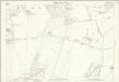
Berkshire IX.4 (includes: Abingdon St Helen Without; Frilford; Marcham; Tubney) - 25 Inch Map
1 : 2500 Topographic maps Ordnance Survey Ordnance Survey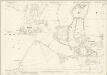
Berkshire IX.8 (includes: Frilford; Marcham; Tubney) - 25 Inch Map
1 : 2500 Topographic maps Ordnance Survey Ordnance Survey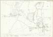
Berkshire IX.8 (includes: Frilford; Marcham; Tubney) - 25 Inch Map
1 : 2500 Topographic maps Ordnance Survey Ordnance Survey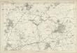
Berkshire IX - OS Six-Inch Map
1 : 10560 Topographic maps Ordnance Survey Ordnance Survey
SU49 - OS 1:25,000 Provisional Series Map
1 : 25000 Topographic maps Ordnance Survey Ordnance Survey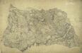
Bampton
1 : 31680 William Stanley was listed as a first class Military surveyor and draughtsman at the Drawing Room of the Tower of London. In 1821, he was asked to revise this plan by the Ordnance Survey's Superintendent, William Mudge. Stanley wrote to explain that he had "a great deal of trouble" in finding his field books and sketches "in consequence of its being so long since it was done, about 10 years." The dirty and torn condition of the drawing most likely results from constant travelling between the Tower and the surveyors in the field for amendments and corrections. Inns named include "Tumble Down Dick", "Rose and Crown", and "Kingstones Inn". Tollgates are also noted. Stanley, William
Abingdon (Hills) - OS One-Inch Revised New Series
1 : 63360 Topographic maps Ordnance Survey Ordnance Survey
Abingdon (Outline) - OS One-Inch Revised New Series
1 : 63360 Topographic maps Ordnance Survey Ordnance Survey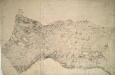
Wantage
1 : 31680 The bottom boundary of this map of White Horse Vale is formed by the Ridge Way, an ancient grass track. The Wiltshire and Berkshire Canal runs through the centre of the landmass. The elaborate hill-shading and the attention paid to communications routes conform to the military and cartographic standards employed by the Ordnance Survey. The manuscript is made up of three separate pieces of paper, joined together at a later date and attached to stiffer paper. Stanley, William
Oxford and Newbury - OS One-Inch Map
1 : 63360 Topographic maps Ordnance Survey Ordnance Survey
Hamp Shire ; Berk Shire ; Wilt Shire
1 : 330000 Berkshire (Anglie) Moll, Herman
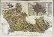
A map of the county of Berks
1 Karte : Kupferdruck ; 43 x 66 cm Rocque; Rocque published according to act of parliament by Mary Ann Rocque near old Round Court in the Strand
An accurate map of Berkshire
1 Karte : Kupferdruck ; 52 x 68 cm Bowen; Tinney; Bowles; Sayer; Bowles; Bowles sold by I. Bowles and son in Cornhill T. Bowles in St. Pauls church yard I. Tinney at the Golden Lion and R. Sayer at the Golden Buck in Fleet street
Bercheria vernacule Bark Shire
1 Karte : Kupferdruck ; 37 x 48 cm Blaeu Joan Blaeu
A new improved map of Oxfordshire
1 Karte : Kupferdruck ; 69 x 51 cm Kitchin; Hinton sold by J. Hinton at the Kings Arms in St. Pauls Church Yard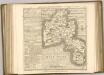
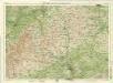
Oxford, Sheet 24 - Bartholomew's "Half Inch to the Mile Maps" of England & Wales
1 : 126720 Topographic maps Bartholomew, John George John Bartholomew & Co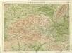
Berkshire, Sheet 29 - Bartholomew's "Half Inch to the Mile Maps" of England & Wales
1 : 126720 Topographic maps Bartholomew, John George John Bartholomew & Co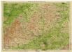
England & Wales [Bartholomew's "Half-inch to the mile" Map of]
J. Bartholomew
BERCHERIA | Vernacule | BARK SHIRE.
[Amsterdam : Joan Blaeu]
Oxonium comitatus vulgo Oxford Shire
1 Karte : Kupferdruck ; 36 x 47 cm Valck; Schenk apud Gerardum Valk et Petrum Schenk