Maps of Totland

SZ38 & Parts of SZ28 - OS 1:25,000 Provisional Series Map
1 : 25000 Topographic maps Ordnance Survey Ordnance Survey
Hampshire and Isle of Wight XCIII.14 & 13 (includes: Totland) - 25 Inch Map
1 : 2500 Topographic maps Ordnance Survey Ordnance Survey
Hampshire and Isle of Wight XCIII.13 (includes: Totland) - 25 Inch Map
1 : 2500 Topographic maps Ordnance Survey Ordnance Survey
Hampshire and Isle of Wight XCIII.13 (includes: Totland) - 25 Inch Map
1 : 2500 Topographic maps Ordnance Survey Ordnance Survey
Hampshire & Isle of Wight XCIII.NW - OS Six-Inch Map
1 : 10560 Topographic maps Ordnance Survey Ordnance Survey
Hampshire & Isle of Wight XCIII.NW - OS Six-Inch Map
1 : 10560 Topographic maps Ordnance Survey Ordnance Survey
Hampshire & Isle of Wight XCIII.NW - OS Six-Inch Map
1 : 10560 Topographic maps Ordnance Survey Ordnance Survey
Hampshire & Isle of Wight XCIII.NW - OS Six-Inch Map
1 : 10560 Topographic maps Ordnance Survey Ordnance Survey
Hampshire & Isle of Wight XCIII.SW - OS Six-Inch Map
1 : 10560 Topographic maps Ordnance Survey Ordnance Survey
Hampshire & Isle of Wight XCIII.SW - OS Six-Inch Map
1 : 10560 Topographic maps Ordnance Survey Ordnance Survey
Hampshire & Isle of Wight XCIII.SW - OS Six-Inch Map
1 : 10560 Topographic maps Ordnance Survey Ordnance Survey
Hampshire & Isle of Wight XCIII.SW - OS Six-Inch Map
1 : 10560 Topographic maps Ordnance Survey Ordnance Survey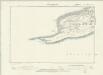
Hampshire & Isle of Wight XCIII.SW - OS Six-Inch Map
1 : 10560 Topographic maps Ordnance Survey Ordnance Survey
Lymington (Hills) - OS One-Inch Revised New Series
1 : 63360 Topographic maps Ordnance Survey Ordnance Survey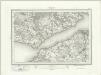
Lymington (Outline) - OS One-Inch Revised New Series
1 : 63360 Topographic maps Ordnance Survey Ordnance Survey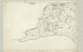
Hampshire & Isle of Wight XCIII - OS Six-Inch Map
1 : 10560 Topographic maps Ordnance Survey Ordnance Survey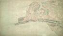
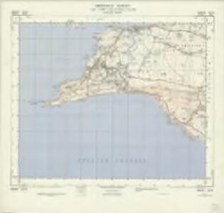
Yarmouth 27A
1 : 10560 A high chalk ridge dominates the coastline at the bottom of this plan of the Isle of Wight, ending in the sea at the far left, where the three pinnacles of the Needles rise to a height of about 30 metres. The drawing is made on rectangular sheet lines, enclosed by a black border. Stonework buildings or structures are drawn in red ink at major settlements like Yarmouth at the top of the map. Gardner, William
Hampshire and Isle of Wight LXXXVIII.13 (includes: Lymington) - 25 Inch Map
1 : 2500 Topographic maps Ordnance Survey Ordnance Survey
Hampshire and Isle of Wight LXXXVIII.13 (includes: Lymington) - 25 Inch Map
1 : 2500 Topographic maps Ordnance Survey Ordnance Survey
Hampshire and Isle of Wight LXXXVIII.13 (includes: Lymington) - 25 Inch Map
1 : 2500 Topographic maps Ordnance Survey Ordnance Survey
Hampshire and Isle of Wight LXXXVIII.13 (includes: Lymington) - 25 Inch Map
1 : 2500 Topographic maps Ordnance Survey Ordnance Survey
Vectis Insula. Anglice The Isle Of Wight. [Karte], in: Theatrum orbis terrarum, sive, Atlas novus, Bd. 4, S. 183.
1 Karte aus Atlas Blaeu, Joan Blaeu, Willem Janszoon
Vectis Insula. Anglice The Isle Of Wight. [Karte], in: Theatrum orbis terrarum, sive, Atlas novus, Bd. 4, S. 183.
1 Karte aus Atlas Blaeu, Joan Blaeu, Willem Janszoon
Vectis Insula. Anglice The Isle Of Wight. [Karte], in: Le théâtre du monde, ou, Nouvel atlas contenant les chartes et descriptions de tous les païs de la terre, Bd. 4, S. 161.
1 Karte aus Atlas Blaeu, Willem Janszoon und Blaeu, Joan Blaeu, Willem Janszoon
Map of Hampshire, including the Isle of Wight, 5
1 Blatt : 52 x 68 cm s.n.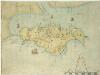
Description of the Isle of Wight
This map of the Isle of Wight dates from around 1600. It is titled on the reverse "Description of the Isle of Wight". A scale bar is included with the motif of dividers, stating ‘Scala Miliaria’, revealing that the map is drawn on a scale of half an inch to one mile. We can not be certain of the identity of the cartographer of this map but it may be one which is thought to have been produced by William White, which was then augmented and published by John Speed in his Theatre of the Empire of Great Britaine. Both this map and the Speed map exaggerate the width of waterways, the depth of bays and prominence of headlands, in a similar way. Such exaggerations suggest that this map was not the result of survey and was drawn by eye. The beacon network on the island is shown by pictorial representations of individual beacons. The Needles are represented by three squat triangles and labelled ‘The nedles’. The period during which this map was produced saw England at war with Spain. The emphasis on the beacon network suggests that the map is concerned with defence in this climate of unease. Since the accession of the Protestant Elizabeth I to the English throne in 1558 Anglo-Spanish relationship had deteriorated. The continued English raids on Spanish colonial interests and England’s support of the Protestant rebellion in the Spanish ruled Netherlands had induced the Catholic Philip II to plan an invasion of England. Although the Spanish were dramatically defeated by the English in 1588, England remained at war with Spain for many years and further attempts to invade were made by Philip of Spain with the dispersal of the ‘second Armada’ in October 1596 and the assembly of the ‘third Armada’ in the following spring. White, William
Wight Vectis olim [Karte], in: Atlas, sive, Cosmographicae meditationes de fabrica mundi et fabricati figura, S. 125.
1 Karte aus Atlas Mercator, Gerhard
Bournemouth - OS One-Inch Map
1 : 63360 Topographic maps Ordnance Survey Ordnance Survey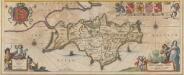
Vectis Insula Anglice The Isle of Wight. [Karte], in: Novus atlas absolutissimus, Bd. 8, S. 104.
1 Karte aus Atlas Janssonius Offizin