Maps of Wales

SR99 & Parts of SR89 - OS 1:25,000 Provisional Series Map
1 : 25000 Topographic maps Ordnance Survey Ordnance Survey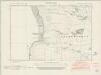
Pembrokeshire XLII.NW - OS Six-Inch Map
1 : 10560 Topographic maps Ordnance Survey Ordnance Survey
Pembrokeshire XLII.NW - OS Six-Inch Map
1 : 10560 Topographic maps Ordnance Survey Ordnance Survey
Pembrokeshire XLII.SW - OS Six-Inch Map
1 : 10560 Topographic maps Ordnance Survey Ordnance Survey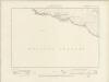
Pembrokeshire XLII.SW - OS Six-Inch Map
1 : 10560 Topographic maps Ordnance Survey Ordnance Survey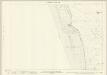
Pembrokeshire XLII.1 (includes: Castlemartin) - 25 Inch Map
1 : 2500 Topographic maps Ordnance Survey Ordnance Survey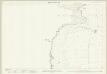
Pembrokeshire XLII.5 (includes: Castlemartin) - 25 Inch Map
1 : 2500 Topographic maps Ordnance Survey Ordnance Survey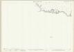
Pembrokeshire XLII.9 (includes: Castlemartin) - 25 Inch Map
1 : 2500 Topographic maps Ordnance Survey Ordnance Survey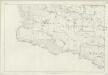
Pembrokeshire XLII - OS Six-Inch Map
1 : 10560 Topographic maps Ordnance Survey Ordnance Survey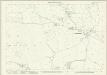
Pembrokeshire XLII.2 (includes: Castlemartin) - 25 Inch Map
1 : 2500 Topographic maps Ordnance Survey Ordnance Survey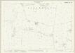
Pembrokeshire XLII.6 (includes: Castlemartin) - 25 Inch Map
1 : 2500 Topographic maps Ordnance Survey Ordnance Survey
Pembrokeshire XLII.10 & 14 (includes: Castlemartin) - 25 Inch Map
1 : 2500 Topographic maps Ordnance Survey Ordnance Survey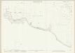
Pembrokeshire XLII.10 & 14 (includes: Castlemartin) - 25 Inch Map
1 : 2500 Topographic maps Ordnance Survey Ordnance Survey
Pembrokeshire XXXVIII.SE - OS Six-Inch Map
1 : 10560 Topographic maps Ordnance Survey Ordnance Survey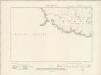
Pembrokeshire XXXVIII.SE - OS Six-Inch Map
1 : 10560 Topographic maps Ordnance Survey Ordnance Survey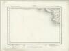
Linney Head (Outline) - OS One-Inch Revised New Series
1 : 63360 Topographic maps Ordnance Survey Ordnance Survey
Linney Head (Hills) - OS One-Inch Revised New Series
1 : 63360 Topographic maps Ordnance Survey Ordnance Survey
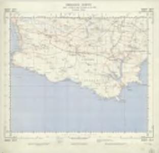
Milford Haven
1 : 31680 This plan of the Cleddau estuary shows the new towns and dockyards at Milford Haven and Pembroke Dock. In 1790, Parliament granted Sir William Hamilton permission to build a new port on the north bank of the Cleddau estuary. Quaker whalers from Nantucket settled in Milford Haven in 1793. Four years later, the Navy Board established a dockyard here to build warships. Near the right margin of the sheet, on the south bank of the Cleddau, the new town of Pembroke Dock is indicated by the letter ''F''. Founded in 1814, and reliant on industry generated by the dockyard, Pembroke Dock flourished as the original New Town of the 19th century. Budgen, Thomas
Ports & Harbours on the South-West Coast of England.
Fullarton, A. & Co.
Plan of Milford Haven
This is a plan of Milford Haven in Wales. It is perhaps associated with proposals in the mid 1590’s for using Milford Haven as a naval base against a Spanish invasion of the Bristol Channel and the Severn. The purpose of the plan seems to be to illustrate roads and anchorages in the Haven which are indicated by ships and a galley at anchor. The map betrays concern with invasion by sea as the coast line is shown in elevation whereas no inland detail is recorded. In August 1595 the Earl of Essex advised the Queen, against the enemy’s design upon Wales and the River of Severn. The Anglo- Spanish relationship had steadily deteriorated since the accession of the Protestant Elizabeth I. Raids on transatlantic shipping by English seamen such as Francis Drake and England’s support of the Protestant rebellion in the Spanish ruled Netherlands had brought tensions with Spain to a crescendo culminating in the events of the Spanish Armada. Although the Spanish Armada was defeated by the English in 1588 England remained at war with Spain for many years and further attempts to invade were made by Philip II with a second Armada’ dispersed in October 1596.
Pembrokeshire XXXIX.SW - OS Six-Inch Map
1 : 10560 Topographic maps Ordnance Survey Ordnance Survey
Pembrokeshire XXXIX.SW - OS Six-Inch Map
1 : 10560 Topographic maps Ordnance Survey Ordnance Survey
Pembrokeshire XXXVIII - OS Six-Inch Map
1 : 10560 Topographic maps Ordnance Survey Ordnance Survey
Pembrokeshire XXXIX.14 (includes: Castlemartin; Hundleton; Rhoscrowdder) - 25 Inch Map
1 : 2500 Topographic maps Ordnance Survey Ordnance Survey
Pembrokeshire XXXVIII.NW & SW - OS Six-Inch Map
1 : 10560 Topographic maps Ordnance Survey Ordnance Survey
Pembrokeshire XXXVIII.NW & SW - OS Six-Inch Map
1 : 10560 Topographic maps Ordnance Survey Ordnance Survey
Pembroke - OS One-Inch Map
1 : 63360 Topographic maps Ordnance Survey Ordnance Survey
PENBROK Comitat.
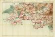
This is a map of Pembrokeshire by Christopher Saxton dating from 1578. It forms part of an atlas that belonged to William Cecil Lord Burghley, Elizabeth I’s Secretary of State. Burghley used this atlas to illustrate domestic matters. This map is actually a proof copy of one which forms part of Christopher Saxton’s Atlas of England and Wales. This atlas was first published as a whole in 1579. It consists of 35 coloured maps depicting the counties of England and Wales. The atlas is of great significance to British cartography as it set a standard of cartographic representation in Britain and the maps remained the basis for English county mapping, with few exceptions, until after 1750. During the reign of Elizabeth I, map use became more common, with many government matters referring to increasingly accurate maps with consistent scales and symbols, made possible by advances in surveying techniques. Illustrating the increasing use of maps in government matters, Lord Burghley, who had been determined to have England and Wales mapped in detail from the 1550s, selected the cartographer Christopher Saxton to produce a detailed and consistent survey of the country. The financier of the project was Thomas Seckford, Master of Requests at the Court of Elizabeth I, whose arms appear, along with the royal crest, on each map. Burghley has annotated this map, adding place names and a dotted line marking the route from Manernowen on the coast to Cardigan. At this time England was under threat of invasion from Catholic Spain, a threat which culminated in the events of the Spanish Armada. Defence of the realm depended on a good geographic and topographic knowledge, explaining Burghley's use of maps and his annotation of them, particularly at coastal locations. The map was engraved by one of a team of seven English and Flemish engravers employed to produce the copper plates for the atlas, although the individual engraver is not noted. Saxton, Christopher William Cecil, Lord Burghley
PENBROK comitat
This map of Penbrokeshire is from the 1583 edition of the Saxton atlas of England and Wales.This atlas was first published as a whole in 1579. It consists of 35 coloured maps depicting the counties of England and Wales. The atlas is of great significance to British cartography as it set a standard of cartographic representation in Britain and the maps remained the basis for English county mapping, with few exceptions, until after 1750. During the reign of Elizabeth I map use became more common, with many government matters referring to increasingly accurate maps with consistent scales and symbols, made possible by advances in surveying techniques. Illustrating the increasing used of maps in government matters, Lord Burghley, Elizabeth I’s Secretary of State, who had been determined to have England and Wales mapped in detail from the 1550s, selected the cartographer Christopher Saxton to produce a detailed and consistent survey of the country. The financier of the project was Thomas Seckford Master of Requests at the Court of Elizabeth I, whose arms appear, along with the royal crest, on each map. Saxton, Christopher Ryther, Augustine