Maps of Ceredigion

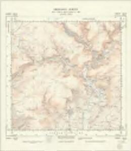
SN74 - OS 1:25,000 Provisional Series Map
1 : 25000 Topographic maps Ordnance Survey Ordnance Survey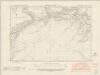
Carmarthenshire IX.NE - OS Six-Inch Map
1 : 10560 Topographic maps Ordnance Survey Ordnance Survey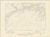
Carmarthenshire IX.NE - OS Six-Inch Map
1 : 10560 Topographic maps Ordnance Survey Ordnance Survey
Carmarthenshire IX.NE - OS Six-Inch Map
1 : 10560 Topographic maps Ordnance Survey Ordnance Survey
Carmarthenshire IX.SE - OS Six-Inch Map
1 : 10560 Topographic maps Ordnance Survey Ordnance Survey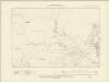
Carmarthenshire IX.SE - OS Six-Inch Map
1 : 10560 Topographic maps Ordnance Survey Ordnance Survey
Carmarthenshire IX.SE - OS Six-Inch Map
1 : 10560 Topographic maps Ordnance Survey Ordnance Survey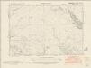
Cardiganshire XXXV.SE - OS Six-Inch Map
1 : 10560 Topographic maps Ordnance Survey Ordnance Survey
Cardiganshire XXXV.SE - OS Six-Inch Map
1 : 10560 Topographic maps Ordnance Survey Ordnance Survey
Carmarthenshire II.SE - OS Six-Inch Map
1 : 10560 Topographic maps Ordnance Survey Ordnance Survey
Cardiganshire XLIII.NW - OS Six-Inch Map
1 : 10560 Topographic maps Ordnance Survey Ordnance Survey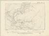
Cardiganshire XLIII.NW - OS Six-Inch Map
1 : 10560 Topographic maps Ordnance Survey Ordnance Survey
Carmarthenshire X.NW - OS Six-Inch Map
1 : 10560 Topographic maps Ordnance Survey Ordnance Survey
Carmarthenshire X.SW - OS Six-Inch Map
1 : 10560 Topographic maps Ordnance Survey Ordnance Survey
Carmarthenshire X.SW - OS Six-Inch Map
1 : 10560 Topographic maps Ordnance Survey Ordnance Survey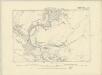
Carmarthenshire X.SW - OS Six-Inch Map
1 : 10560 Topographic maps Ordnance Survey Ordnance Survey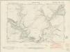
Brecknockshire IX.SW - OS Six-Inch Map
1 : 10560 Topographic maps Ordnance Survey Ordnance Survey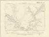
Brecknockshire IX.SW - OS Six-Inch Map
1 : 10560 Topographic maps Ordnance Survey Ordnance Survey
Brecknockshire IX.SW - OS Six-Inch Map
1 : 10560 Topographic maps Ordnance Survey Ordnance Survey
Carmarthenshire X.14 (includes: Llanfair Ar Bryn) - 25 Inch Map
1 : 2500 Topographic maps Ordnance Survey Ordnance Survey
Carmarthenshire XVIII.1 (includes: Cil Y Cwm; Llandingad Without; Llanfair Ar Bryn) - 25 Inch Map
1 : 2500 Topographic maps Ordnance Survey Ordnance Survey
Lampeter (Hills) - OS One-Inch Revised New Series
1 : 63360 Topographic maps Ordnance Survey Ordnance Survey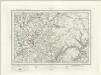
Lampeter (Outline) - OS One-Inch Revised New Series
1 : 63360 Topographic maps Ordnance Survey Ordnance Survey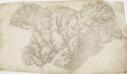
Cardiganshire
1 : 31680 This drawing is formally titled. Its scale is noted and the surveyed area recorded as 205.6742 square miles. Archaeological sites are named in gothic script. Colour washes depicting relief are combined with numerical annotations ('spot heights') in red and black ink giving the heights of the hills. Figures in red represent trigonometrically ascertained altitudes whereas those in black are estimates. On the top left margin a note, dated 1st April 1822, from draughtsman Robert Dawson reads: "Cws yr ychen Bannog, is an ancient Bank said to run from sea to sea. It could not be traced in this survey beyond Carn Cron. The Rev John Williams of Ystrad Meyric supposes it may be a British Road, or a Boundary between two tribes of the Britons". Dawson, Robert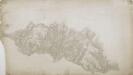
Llandovery(002OSD000000021U00147000)
1 : 31680 This plan of part of East Carmarthenshire and West Pembrokeshire shows the county border as a red line near the right margin of the sheet. A table above the plan gives trigonometrical data. Triangulation,lines in pencil are clearly visible outside the surveyed area. Colour washes are used to indicate relief, with numbers at the summit of inclines giving their altitude in feet. Dawson, Robert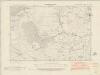
Carmarthenshire XVII.NE - OS Six-Inch Map
1 : 10560 Topographic maps Ordnance Survey Ordnance Survey
Carmarthenshire XVII.NE - OS Six-Inch Map
1 : 10560 Topographic maps Ordnance Survey Ordnance Survey
Carmarthenshire XVII.NE - OS Six-Inch Map
1 : 10560 Topographic maps Ordnance Survey Ordnance Survey
Carmarthenshire XVIII.NW - OS Six-Inch Map
1 : 10560 Topographic maps Ordnance Survey Ordnance Survey
Carmarthenshire XVIII.NW - OS Six-Inch Map
1 : 10560 Topographic maps Ordnance Survey Ordnance Survey