Maps of Ipswich

Ipswitch - OS One-Inch Map
1 : 63360 Topographic maps Ordnance Survey Ordnance Survey
Ipswich
1 : 31680 This drawing of parts of Essex and Suffolk is made up from four conjoined sheets mounted on stiff card. Verron's reputation as a surveyor suffered over the course of the survey. A letter from Survey Superintendent, William Mudge, dated 11 October 1820, reads: "Mr Stanley is going with me ...to Woodbridge to examine what is necessary to be done with Mr Verron's Plans...I apprehend they are much worse than... I expected." Verron
Orford(002OSD000000026U00278000)
1 : 31680 This is an original protraction of the Suffolk coastline, running inland,from Orford Ness,,on the right,,to Hasketon and Wickham., The various traverses (single lines surveyed from different points),are distinguished by colour: red, blue, yellow, light brown and dark brown. ,These skeleton protraction lines,form the first plottings from the field book of the area., At the bottom right, the plan is annotated in blue with the date of the traverse and the,corresponding page numbers in the field book. Metcalf, Edward B
A Coloured Chart of the Coast of Essex and Suffolk, from the Naze to Bawdsey
This is a chart showing Essex and Suffolk from the Naze to Bawdsey showing the course of the Stour, Orwell, and Deben. It is thought to date from between 1539 and 1544. It shows miniaturized views of towns such as Ipswich and Harwich against a generalized green landscape of fields and occasional trees. The coast line and waterways are the main preoccupation of the cartographer as he has carefully recorded areas of sand in pink with stippled markings, and at certain points the depths of the water at low tide in area is noted. The cartographer is Richard Cavendish, whose family home in Suffolk is indicated. Richard Cavendish was a master gunner who had supervised new defence works at Berwick and Wark in 1522-3. It is thought that this map was based on a survey that Cavendish was paid to undertake in 1523. The date exact date of the map is uncertain. It could date from around 1538-9, a period characterised by the threat of invasion after a peace treaty was signed by Francis I of France and Charles V, Holy Roman Emperor and King of Spain in 1538. England and France were ancient enemies and the catholic Charles V, nephew of Catherine of Aragon, was angered by Henry VIII’s decision to divorce her. However, the presence of a scale bar in the bottom right corner suggests a date of post 1540. In 1543 war with France resumed and England was threatened by invasion once again. This map may be related to a large map which is referred to in Henry VIII’s inventory of 1547-80 the description of parte of Suffolke, Essexe and London painted upon clothe’ Cavendish, Richard
Orford(002OSD000000026U00277000)
1 : 31680 This partly finished plan of the Suffolk coastline shows only roads and settlements to the left, but land use and relief detail have been added to the right. Original protraction lines remain in pencil: these represent the first plottings from the field book of the area. The handwritten note pasted at the bottom of the plan may have been trimmed from the margin. Metcalf, Edward B
Felixstowe (Hills) - OS One-Inch Revised New Series
1 : 63360 Topographic maps Ordnance Survey Ordnance Survey
Felixstowe (Outline) - OS One-Inch Revised New Series
1 : 63360 Topographic maps Ordnance Survey Ordnance Survey
Woodbridge (Hills) - OS One-Inch Revised New Series
1 : 63360 Topographic maps Ordnance Survey Ordnance Survey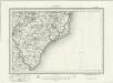
Woodbridge (Outline) - OS One-Inch Revised New Series
1 : 63360 Topographic maps Ordnance Survey Ordnance Survey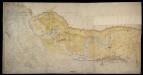
A Coloured Chart of the Coast of Suffolk, from Bawdseye to Thorpe, including Orford and Aldborough
This is a map of the Suffolk coast from Bawdseye to Thorpe. It includes detailed depictions of Orford and Aldeburgh. It is thought to date from between 1575-1600. Whimsically picturesque in style, topographical features are recorded pictorially. Individual architectural features such as Orford castle, village churches and windmills are carefully detailed and all manner of sailing vessels crowd the waterways. However, the purpose of the map is to provide a record of the layout and defensive capacity of the area. The inlets and tributaries of the waterways are recorded as are the sands and channels of the coast. Beacons are shown, with one atop the castle at Orford , built by Henry II in the 1160’s to guard what was then a busy port. The prominence of the windmills is probably due to the fact that they could also be used as vantage points due to their height. Aldeburgh (Albwrghe) is shown as a heavily fortified settlement with cannons occupying a pier and located at intervals along the adjacent sands. As well as two beacons, two windmills and a church are also shown at Aldeburgh all useful due to their height and therefore view of the sea. It is likely that the map was drawn in connection with the contemporary threat from Spain. Since the accession of the Protestant Elizabeth I to the English throne in 1558 Anglo-Spanish relationship had deteriorated. The continued English raids on Spanish colonial interests and England’s support of the Protestant rebellion in the Spanish ruled Netherlands had induced the Catholic Philip II to launch the 1588 Spanish Armada. Although the Spanish Armada was defeated by the English in 1588, England remained at war with Spain for many years and further attempts to invade were made by Philip of Spain with the dispersal of a second Armada’ in October 1596 and the assembly of the third Armada’ in the following spring. In this climate it was naturally coastal areas that were under the closest scrutiny.
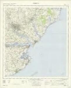
Ipswich (Outline) - OS One-Inch Revised New Series
1 : 63360 Topographic maps Ordnance Survey Ordnance Survey
Ipswich (Hills) - OS One-Inch Revised New Series
1 : 63360 Topographic maps Ordnance Survey Ordnance Survey
Colchester (Outline) - OS One-Inch Revised New Series
1 : 63360 Topographic maps Ordnance Survey Ordnance Survey
Colchester (Hills) - OS One-Inch Revised New Series
1 : 63360 Topographic maps Ordnance Survey Ordnance Survey
TM45 - OS 1:25,000 Provisional Series Map
1 : 25000 Topographic maps Ordnance Survey Ordnance Survey
TM44 - OS 1:25,000 Provisional Series Map
1 : 25000 Topographic maps Ordnance Survey Ordnance Survey
TM35 - OS 1:25,000 Provisional Series Map
1 : 25000 Topographic maps Ordnance Survey Ordnance Survey
TM34 - OS 1:25,000 Provisional Series Map
1 : 25000 Topographic maps Ordnance Survey Ordnance Survey
TM25 - OS 1:25,000 Provisional Series Map
1 : 25000 Topographic maps Ordnance Survey Ordnance Survey
TM33 - OS 1:25,000 Provisional Series Map
1 : 25000 Topographic maps Ordnance Survey Ordnance Survey
TM24 - OS 1:25,000 Provisional Series Map
1 : 25000 Topographic maps Ordnance Survey Ordnance Survey
TM15 - OS 1:25,000 Provisional Series Map
1 : 25000 Topographic maps Ordnance Survey Ordnance Survey
TM23 - OS 1:25,000 Provisional Series Map
1 : 25000 Topographic maps Ordnance Survey Ordnance Survey
TM14 - OS 1:25,000 Provisional Series Map
1 : 25000 Topographic maps Ordnance Survey Ordnance Survey
TM22 - OS 1:25,000 Provisional Series Map
1 : 25000 Topographic maps Ordnance Survey Ordnance Survey
TM13 - OS 1:25,000 Provisional Series Map
1 : 25000 Topographic maps Ordnance Survey Ordnance Survey
TM12 - OS 1:25,000 Provisional Series Map
1 : 25000 Topographic maps Ordnance Survey Ordnance Survey
TM11 & Parts of TM21 - OS 1:25,000 Provisional Series Map
1 : 25000 Topographic maps Ordnance Survey Ordnance Survey
Orwell Haven
This is a map of Orwell Haven, Essex. It is thought to date from1543. It shows proposed fortifications at the mouth of Harwich harbour which were not built. The forts are shown in plan form and have seem to be measured plans, recording details such as the splayed external opening of embrasures and the curved internal space for a man to stand. In this they contrast with the loose pictorial style of the rest of the map. The forts comprise a central fort with a curtain wall with bastions at each corner. The fort at Lagner Point has angular bastions in the Italian style perhaps revealing the influence of the Italian military engineers employed by Henry VIII in the 1540’s. The advantage of angle bastions is that they provide fire power outwards and flanking power along the walls so that no blind spots exist, enabling defenders to cover all the surrounding ground. The concern with the defensive capabilities of Orwell Haven and other coastal area at this date was due to the resumption of hostilities between England and France 1542. The map is the work of Richard Lee, a mason by trade was worked as a surveyor on fortification schemes in England and English territory in France. It is probable that this map was intended for personal explanation by Lee to Henry VIII. Lee, Richard